While these examples indicate that there has been interest in determining the visibility of, and view from, structures in the Rman urban environment, it has proven difficult to determine this with any degree of certainty. The most common method is for archaeologists or art historians to visit the site of a Roman city and, based on their particular knowledge of the site and their ability to envision what the site looked like at a given point in time, they draw conclusions about was or was not visible from any given point. Recently some scholars have experimented with line-of-sight analysis as a way to advance the study of visibility and set their conclusions on a sounder footing (i.e. Favro 1996). The disadvantage of this technique is that it only answers the question of whether point A could be seen from point B: it does not allow one to determine an entire viewshed.
The most important technological advance in the study of view and visibility has come with the development of GIS viewshed analysis. Although viewshed analyses are currently very popular in archaeology (cf. Alvarez-Sanch�s 1994; Wheatley 1995; 1996; Llobera 1996; Lock and Harris 1996; Gillings and Goodrick 1996; Madry and Rakosin 1996; Ruggles and Medyckyj-Scott 1996; van Leusen 1999; Symonds 1999), they have been used only a few times in a classical context (Smith 1995; Loots et al. 1999; Kaiser 2000). In order to conduct a viewshed analysis, a contour map of the area of interest is digitised and elevation values are assigned to each of the contour lines. With this data, the computer applies an algorithm of weighted averages so as to rastorise the vector data and calculate the elevation of every point on the map, whether that point is on or between the digitised contour lines. On the resulting plan, known as a Digital Elevation Model (DEM), one can select any point and determine what parts of the plan could be seen from that point and, therefore, from where in the landscape that point could have been seen. Natural and cultural factors can be taken into account by adding layers on top of the DEM. For instance, tree cover can be added if the evidence supports this in certain parts of the area of interest. Buildings can also be added to the landscape when their heights in antiquity are known or can be estimated. When enough archaeological evidence is available, it is possible to reconstruct the viewshed of any point within an ancient built landscape, namely a city.
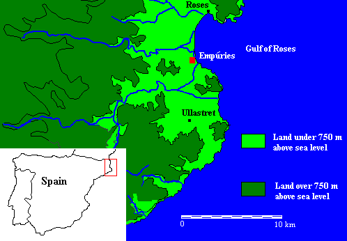
Figure 1: Location of Empúries on the Iberian Peninsula
The important constraint in conducting a viewshed analysis of an ancient cityscape is the amount of archaeological evidence available. Rarely has enough of a site been excavated to allow us to know the details of the appearance of the cityscape at a specific point in time. Without this contemporary evidence, it is impossible to conduct a proper viewshed analysis. One unusual ancient urban site with enough evidence available to conduct a viewshed analysis is the Greco-Roman colony at the site known in Catalan as Empúries and Castillian as Ampurias. Empúries is located about 100km north of Barcelona on the north-eastern coast of Spain (Fig. 1) and has been extensively excavated in nearly annual campaigns since 1908 (Mar and Ruiz 1993, 58 ff.). As a result, we have an unusually good understanding of this ancient urban landscape.
© Internet Archaeology
URL: http://intarch.ac.uk/journal/issue14/2/3.0.html
Last updated: Thu Jun 12 2003