The area around Buckley in Flintshire, north Wales, has been associated with the production of pottery for at least 600 years. To understand why Buckley developed as a potting centre, it is necessary to examine its location. As with other major production areas, its geological and geographical location was the prime reason why the pottery industry developed.
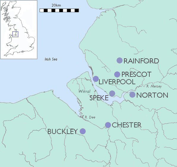
Figure 1: North Wales and Merseyside
Buckley is situated 12km west of the city of Chester and 4km north of Mold at a height of 140m above sea level on Buckley Mountain, about 5km south of Connah's Quay, on the Dee Estuary (Fig. 1).
The solid geology of the region is Carboniferous Limestone, which is overlain by Coal Measures (for local geology, view the online British Geological Survey map). The area around Buckley is composed of Middle Coal Measures, the upper layers constituting the Buckley Fireclay Group (Wedd and King 1924, 61). The Buckley Fireclay outcrops along the line of a major fault, the Great Fireclay Fault. Smaller faults in the coalfields gave rise to horst and graben structures. These are small uplifted fault-blocks separated by down-thrown segments (Smith and George 1961, 73). These exposed the clays and coal seams, which attracted the potters to Buckley. The faulting caused mineralisation to take place along the eastern Carboniferous outcrop on the limestone, producing lead sulphide (galena), the source of lead for glazing the pots (ibid, 73).
During the glacial period, boulder clay was deposited from two sources. The Northern Drift comprises bands of buff loam within red boulder clay. It is composed largely of Triassic material from the bed of the Irish Sea, south Lancashire and the Wirral peninsula, and in the north-east part of the district is identical in character with that of the Wirral drift (Wedd and King 1924, 145). The Welsh Drift appears as a stiff yellow clay and where the Welsh and Northern Drifts meet there is partial mingling (ibid, 146). The boulder clay of the Buckley region is generally red. In the vicinity of Buckley Mountain there is a tough grey till which was a basal deposit of the ice-sheet, and is composed almost entirely of Coal Measures shales. This grey till may be the yellowish-brown clay found in a weathered state on the Common at Buckley Mountain (ibid, 157). White clays were produced in pockets in the Carboniferous Limestone in the pre-glacial period (ibid, 174).
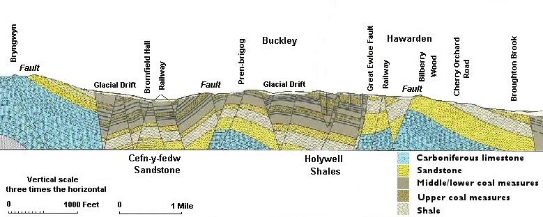
Figure 2: Cross-section to show faulting (after Geological Survey of Great Britain (England and Wales), Solid Sheet 108 (Flint) 1965)
The raw materials were immediately available. Transport was comparatively easy in that the pots were carted down the hill to the Dee Estuary and then exported by water either to Chester market or to ports around the Irish Sea.
© Internet Archaeology
URL: http://intarch.ac.uk/journal/issue16/1/ch2.1.html
Last updated: Wed Mar 24 2004