In 1877, the Nez Perce (a Plateau tribe from western Idaho/eastern Oregon) migrated through the newly created Yellowstone National Park while being pursued by the US Army. Without going into detail about the causes of the Nez Perce war, it is important to note that certain members of the tribe were knowledgeable about the Bannock Trail (the main east–west artery through the region at the time), while the majority had no experience in the area. A combined cost-distance and viewshed analysis of all areas immediately visible and within easy reach of the Bannock Trail was used as a proxy representation of aggregate community knowledge of an avenue of escape through very poorly known hostile terrain (Figure 4). In this figure, more detailed knowledge is represented by darker shades, while a lack of spatial knowledge is represented by white. The actual route taken by the Nez Perce was recorded historically, though, and does not conform to what we would expect given the level of regional spatial knowledge for the tribe. When seen in the absence of more detailed understanding of the conflict between the US Army and the Nez Perce, it is not easy to see why a group with limited experience in the region would choose to take an unknown route when migrating through the area.
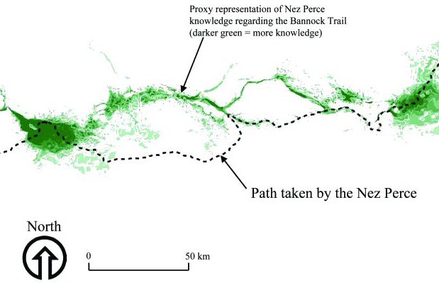
Figure 4: Knowledge of the Bannock trail
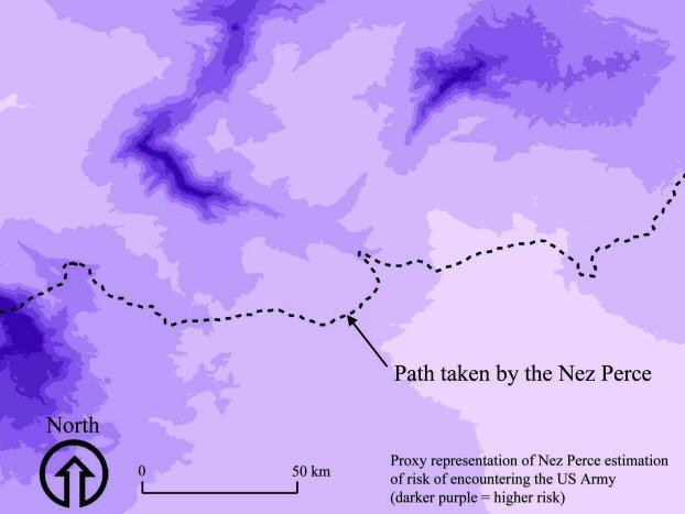
Figure 5: Risk of encountering the US Army
Several additional proxy variables were measured and combined with the Nez Perce spatial knowledge surface. The first was a cost-distance analysis from every point where it was known (by the tribe) that the US Army might be encountered (Figure 5). This was a proxy representation of the Nez Perce's estimation of the risk of encountering the enemy based on known contemporary Euro-American settlements and encampments. The second was a representation of the spatial knowledge acquired by John Shively, a white civilian who had previously traversed alternative trails in the region and was kidnapped by the Nez Perce shortly after they entered the area (Figure 6). Ultimately, a combined viewshed/cost-distance analysis of the path taken by Shively prior to being kidnapped coupled with the other spatial proxies was instrumental in understanding the decision to take the alternate route (Figure 7). The complete cost-benefit surface shown in Figure 7 illustrates the impetus for making the seemingly unusual trajectory decision presented in Figure 4.
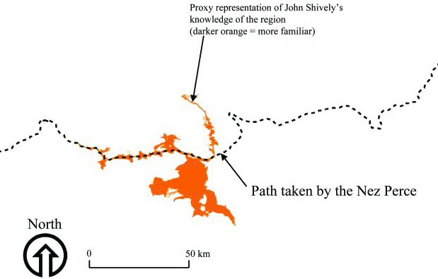
Figure 6: Shively's knowledge
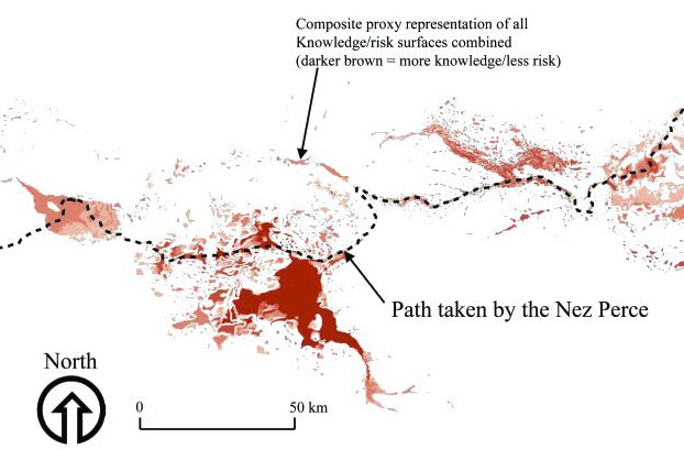
Figure 7: Composite of all knowledge and risk surfaces
Since we have detailed historical information regarding the conflict we can model how the Nez Perce cognitively assessed their surroundings using these spatial proxies. In terms of their nature, group aggregate spatial knowledge can be seen as being both directly and indirectly causally related to several different conceptions of visibility and cost-distances. The cognitive decision to make an alternative trajectory choice is predominantly an indirect causal effect of past conceptions of spatial criteria. Although that cognitive action reflects a communal decision (albeit directed by tribal leaders) it is largely built from an agent-based cognitive landscape (namely the cognitive landscapes of Shively and the few other members of the tribe familiar with routes in the area). The weighting and ranking of spatial proxy surfaces, in this case, is a simulation of the decision-making process itself, where Shively's information was evaluated for accuracy and weighed against that of alternate sources to arrive at a decision threshold.
© Internet Archaeology
URL: http://intarch.ac.uk/journal/issue16/3/4.1.html
Last updated: Thur Nov 11 2004