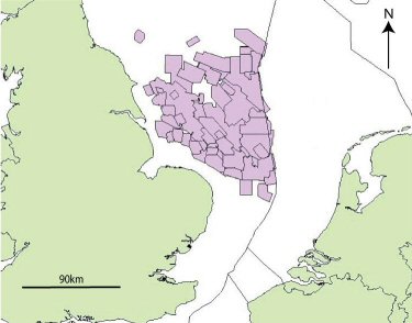
Figure 1: Location of the >22,000km2 of English 3D Seismic Surveys within the Southern North Sea
(data courtesy of http://www.ukdeal.co.uk and CDA Ltd.)
Figure 1: Location of the >22,000km2 of English 3D Seismic Surveys within the Southern North Sea
(data courtesy of http://www.ukdeal.co.uk and CDA Ltd.)
Archaeologists have long recognised the potential of the Southern North Sea as an area of Mesolithic occupation, and some have even considered the area as the heartland of Mesolithic North Western Europe (e.g. Clark 1936). Despite this little archaeological prospection has been conducted within the area, and it remains effectively terra incognita to mainstream archaeology. The elusive nature of the landscape has permitted few substantive commentaries on the region (e.g. Jacobi 1976), before Coles' (1998) formative paper on Doggerland. Yet whilst this speculative survey served to rally interest in marine prehistory in reality it presented little new evidence with respect to the prehistoric landscape of the region. Consequently, published maps, which largely reflect a lack of physical survey, have served to reinforce an archaeological perspective that this region was irrelevant (Coles 1999: 51). Attempts to rectify this absence of information have mainly been through the utilisation of isostatic rebound models. Whilst they provide outline representations of the former landscape (e.g. Lambeck 1995, Shennan 2000), the scales at which these coarse models operate make them unsuitable for the purposes of archaeological interpretation. Even when considering higher resolution local models, the utilised cell size (1.2km x 1.2km, Shennan 2002: 513) is still reasonably large for archaeological purposes. This factor combined with the lack of inclusion of important oceanographic and geological factors, such as burial and erosion, make these models still far from ideal (Bell et al. 2006, Box 1, 14). Given the issues associated with isostatic modelling and its use in archaeology, other methods therefore need to be found if we are to survey the marine prehistory of this region adequately .
It is also true that marine prehistory often suffers from being "out of sight" and therefore the mind of terrestrial archaeologists in research terms. To a certain extent this situation reflects the prohibitive cost of performing survey within an offshore marine environment in comparison to land based archaeology. The consequence of this lack of research is such that our understanding of the Mesolithic landscape constituting "Doggerland" has advanced little from studies of the 1930's (Coles 1998, 50). Despite having made these pessimistic observations it remains true that this region probably contains one of the most detailed and comprehensive records of the Late Quaternary and Holocene (Fitch et al. 2005, 187), and represents a mine of information for the Late Palaeolithic and Early Mesolithic studies as yet untapped by archaeologists. Consequently, if Mesolithic archaeology is to move into a position of understanding, the need for more detailed survey of this core area is pressing. Indeed Caroline Wickham-Jones (2005, 33) recognised this situation when she suggested that "archaeologists of the Mesolithic should now investigate the potential of the under-sea world".
The academic imperative for further work in the North Sea is matched by considerable heritage concerns. Commercial development is occurring at an increasing pace in the region and there is a pressing need for archaeological information on a spatially extensive scale to aid both research and heritage management. However, whilst the commercial development of this region represents a risk to the archaeology it may also be perceived as an opportunity. The vast 3D Seismic datasets acquired on the United Kingdom continental shelf for exploring deep geology, if utilised correctly, can be seen to represent an invaluable archaeo-geophysical data mine for the investigation of the Mesolithic landscape. These surveys cover more than >22,000km2 in the Southern North sea alone (Figure 1) and although the potential of this data to inform submerged archaeological prospection has been observed this opportunity has never been realised (Kraft et al. 1983). Most archaeological work has been focused on specialist 3D Seismic datasets utilising very high resolution systems (Bull et al. 2005), and on small sites (e.g. Mueller et al. 2006). Unfortunately the small areas involved and the high cost of deployment suggest that it is unviable to deploy these methods at a regional scale. The opposite is true for petroleum 3D Seismic data. Although it is inappropriate for use for small scale or site survey, its extensive nature makes it ideal for landscape studies. With a spatial resolution of petroleum industry datasets approaching 12.5m, an opportunity exists to map the Mesolithic landscape at a regional scale with unprecedented detail. This paper presents some of the results from PhD. research undertaken by Simon Fitch at Birmingham University, and the larger North Sea Palaeolandscapes Project, which demonstrates that recovery of archaeological landscape information through extensive 3D Seismic data is both possible and desirable. The information derived provides a unique opportunity to explore human activities within a spatially extensive prehistoric landscape and, more fundamentally, when considered within the framework of the larger Birmingham North Sea Palaeolandscape Project suggests that the landscape would have contained a significant Mesolithic population. An appreciation of the nature of Mesolithic occupation of this region will remove the constraints currently imposed by a limiting terrestrial perspective and allow Mesolithic archaeologists to ask fundamental and pertinent research questions about the region and its archaeology.
© Internet Archaeology
URL: http://intarch.ac.uk/journal/issue22/3/intro.html
Last updated: Tues Oct 2 2007