In this paper, a focus area of 20 x 35 km has been chosen to illustrate the work currently being undertaken within this region. The study covers both flanks of the main depression within this region: the Outer Silver Pit, some 120 km from the nearest landmass. The main source of data for this paper is a 3D MegaSurvey seismic dataset which has been kindly provided for the purposes of this research by PGS UK Ltd. (http:// www.pgs.com).
The initial visualisation of this data was achieved by time slicing a 3D Seismic data cube at 4ms intervals from 60ms, the first seabed multiple image, through to 200ms where clearly resolvable glacial features appeared. Where the sea bed was poorly resolved multiples were used in the time slicing to gain a full understanding of the features at or near the seabed (see Fitch et al. 2005 for more detailed information on the seismic analysis).
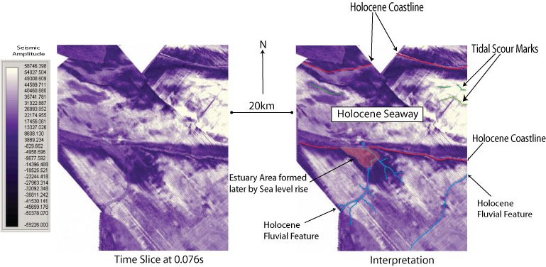
In addition to time slicing the data archaeologically relevant horizons were identified within the data and these surfaces exported into a GIS to facilitate the building of a terrain model associated with the Mesolithic land surface. The integration of seismic data in the form of GeoTIFF slices into a GIS permitted further opportunities for analysis and interpretation of the data. In conjunction with the terrain model it becomes possible to accurately position landscape features within the GIS. Additional benefits include correlation with other non-seismic data sets (e.g. core location databases or geological mapping). Cross correlation with these supported the interpretation of otherwise problematic features. This analysis permitted a range of Holocene landscape features to be identified and a sample is shown in Figure 4 where a time slice at 0.076s and its interpretation provides evidence for the contemporary coastline, estuaries and fluvial features including major river systems that were active during the Mesolithic period. The considerable detail provided by seismic studies is very significant and this provides the opportunity for detailed modelling of past communities and the potential to plan further fieldwork within the North Sea to support archaeological research and to aid management strategies for what must, at the very least, be one of the most extensive and best preserved prehistoric landscapes in Europe.
Figure 4: The structure of the Holocene landscape can clearly be seen in this Seismic timeslice taken at 0.076s. The quality of the seismic data allows the image to be interpreted in a manner similar to satellite imagery. Coastlines, Estuaries and large fluvial features in this image can all be seen to be integral parts of the Mesolithic landscape of this region.