Having demonstrated the significance of the submerged landscapes around the British Isles and the potential of 3D Seismic for mapping the region, it should be clear that the next step is to enlarge the scale of research from the mere six thousand square kilometres of the study area discussed here. This has, in fact, already begun. The North Sea Palaeolandscapes Project, staffed in part by the authors and others1, is a large scale marine landscape project funded by the Aggregates Levy Sustainability Fund and managed by English Heritage. It is currently seeking to explore the Holocene landscape of the Southern North Sea through the utilisation of some c.23,000km2 of 3D Seismic data provided for research at Birmingham by PGS UK (http://www.pgs.com). This area approximates an area the size of Wales and represents the largest continuous geophysical survey ever utilised for archaeological purposes. Following 18 months work the first phase of the project is now drawing to a close and the results of mapping this large area will be published shortly as an atlas of the region. It is hoped that further funding will be found to extend this work into other areas.
Another logical step is the utilisation of the extensive landscape information to facilitate archaeological predictive modelling. Given the expense of working in the marine environment almost all site scale work must be targeted. Whilst models, including the "Danish Fishing Model", do exist for prospection and are reported to be very successful; (Fischer 1995, 375), these have used localised bathymetry as a topographic proxy. This inevitably has led to them performing less successfully in waters deeper than 10m or in areas where burial of the landscape has occurred (Fisher 1995, 377). The utilisation of information from seismic data should help improve such modelling strategies by providing data which is not affected by these limitations.
The areas of coastline observed within the seismic data so far suggest that on landscape requirements alone the area may be amenable to the utilisation of this model. Further, the presence of large rivers that directly connect to a marine coastline fit admirably to the landscape characteristics required by the model (Fischer 1995, 374, fig 5.). However, caution must be considered with the utilisation of this model, especially in the North Sea, since the area represents a slightly earlier archaeological period and a slightly different marine environment. It is therefore possible that the settlement patterns in the North Sea may have been different to that predicted by this model, posing a potential risk. However this must be tempered by the fact that we have no knowledge of the utilisation of coastal resources from this area during the early Mesolithic due to sea level rise (Coles 1998, 74). Any attempt to test this model in a different area will not only provide valuable information about the validity and cross transference of this model in other environments, which is sorely required, but also provide new information upon the Mesolithic in this area which can be utilised to produce new more refined models (Kamermans & Wansleeben 1999). The generation of further predictive models using the North Sea seismic data for this area has formed a part of the postgraduate research to be carried out at Birmingham and now is beginning to generate interesting results (see Figure 7).
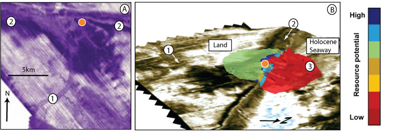
Figure 7: An illustration of some of the early results of site prediction. Figure 7 (A) shows a predicted site (orange dot) in relation to the seismic data within the study area. It can be observed to fall close to the shoreline and both the estuarine and fluvial environments. In 3D View of Figure 7 (B) the predicted resource distribution for this site is shown (scale bar is relative), which suggests that resource utilisation of the coastline may have been favoured by the inhabitants of the region.
The final area of research involves the development of novel technologies to examine and represent the challenging data from the North Sea (Fitch et al. 2005, Cameron et al. 1992). Given the inaccessibility of the region few archaeologist and fewer members of the public will ever be able to experience the actual marine environment or, given the scale of the data, even the results of analysis. It seems likely that the only way we will be able to perceive or, perhaps, "visit" this landscape will be through Virtual Reality technologies. (Figure 8) These will be vital not only to inform our academic studies, they will also provide the wider public with a sense of ownership of what must be one of the most alien of our cultural heritages. This level of public accessibility will be vital given the emerging threats to what is probably Europe's best preserved in-situ prehistoric landscape.
Figure 8: A visualisation of the marine inundation of the Mesolithic landscape of the study area.[File in AVI format]
This movie clearly illustrates the benefits of virtual reality technology when dealing with marine prehistory. The movie begins by moving from a recreation of the seabed in the area today. The movie then moves onto a visualisation of the marine inundation of the Mesolithic landscape of this area during 12,000BP to 9,000BP. Through this visualisation it becomes possible to begin to appreciate the vast temporal and spatial changes that are recorded and preserved in the submerged Mesolithic landscape of this region.
(Movie courtesy of Steve Wilkes of HP VISTA at the University of Birmingham)
Looking beyond that there are many marine areas with comparable histories and which have also been subject to mineral exploration. These could also benefit from similar research programmes and it is the desire of the authors to expand our interests into some of these other areas. In doing so we would hope to develop the methodologies presented here but also to encourage other archaeologists to consider the significance of submerged prehistoric landscapes to wider interpretative schemes.
1 Individuals involved in the projects aside from the authors are Kate Briggs, Simon Holford, Mark Bunch, Andy Howard, David Smith, Ben Gearey, Eugene Ch'ng, Bob Stone.