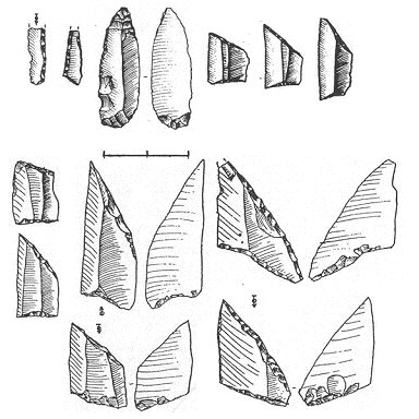
Figure 3: Paardsdrank (above; from Weelde-'Paardsdrank' - Huyge and Vermeersch 1982) and Ruiterskuil (below; from Opglabbeek-'Ruiterskuil' - from Vermeersch et al. 1974) assemblage types
Figure 3: Paardsdrank (above; from Weelde-'Paardsdrank' - Huyge and Vermeersch 1982) and Ruiterskuil (below; from Opglabbeek-'Ruiterskuil' - from Vermeersch et al. 1974) assemblage types
The available evidence for later Mesolithic cultural landscapes in the Scheldt basin comprises mostly (>90%) surface scatter accumulations of palimpsests that hinder the chronological representativity of lithic assemblages. While there is significant overlap between different assemblage types in the Preboreal (Neerharen, Ourlaine, Verrebroek) and Boreal periods (Ourlaine, Chinru) (Crombé 1999; 2002), the Atlantic period suggests a lack of regional variability in assemblage types. The two assemblage types from the Late Mesolithic are the Groupe de Paardsdrank and Groupe de Ruiterskuil (Figure 3): Paardsdrank assemblage types are comprised of base décalée, rectangular, and asymmetric trapezes (45-65%) as well as numerous types of older armatures (backed bladelets, points with invasive retouch, non-retouched points, scalene triangles); whereas Ruiterskuil assemblages contain nearly all trapezes (80-90%), and are signified by an important number of points with flat ventral retouch (25-50%) (Crombé 1999, 193-94). For the Late Mesolithic the only secured absolute (AMS) dates are for the Groupe de Paardsdrank, which ranges roughly from 6200-5700/5600 BC (ibid.). Most scholars agree that the points with flat ventral retouch found in the Ruiterskuil group suggest an 'evolved' state later than those of the Paardsdrank group (cf. Crombé in press; Ducrocq 2001; Van Assche 2005). The key reference for the Ruiterskuil assemblage type (specifically, the armatures evoluée) comes from the date of 6090 ± 95 (Gif 10419) at Castel in the Somme valley (Ducrocq 2001, 124). Despite the problems with chronological precision, the different assemblage types and guide artefacts/attributes (e.g. rhombic trapezes, flèche de Belloy, flat ventral retouch), and their relative distributions throughout the landscape, do yield fairly rough accuracy as to the general habitation period of a particular scatter, even if that scatter indicates occupations from the Preboreal-Atlantic. The coarse chronological base does, however, yield significant insight into the general paleoecological contexts of later Mesolithic settlement systems.
Recent studies in Hainaut and Sandy Flanders have allowed for a preliminary comparative assessment of Late and Final Mesolithic cultural landscapes between the middle and lower Scheldt basin. These studies reveal particular patterns in later Mesolithic settlements with regard to specific natural features within the landscape. The Hainaut evidence indicates a preference for sandy soils on tertiary outcrops, but also suggests important clusters on sandy-loamy soils, as well as sporadic habitations on the edge of loess plateaus (Van Assche 2005). These data suggest a higher degree of diversity in Late-Final Mesolithic settlement systems in the loess region in relation to local pedology and topography. The most significant general pattern of Late-Final Mesolithic settlements in the middle Scheldt is their proximity to bodies of water, whether river valleys, streams, or marshy wetland areas. Unfortunately, this conclusion also reinforces the idea that many Late and Final Mesolithic sites may be unidentifiable during archaeological surveys as a result of their depths beneath colluvium and alluvium, as well as because of probable post-depositional erosion (cf. Crombé et al. in press; Van Assche 2005) that took place as the floodplain widened through the Atlantic.
Research in the Sandy Flanders region of the lower Scheldt basin has indicated dramatic changes in site abundance and settlement location through the course of the Mesolithic. Crombé et al. (in press) note that during the late Boreal/Middle Mesolithic period (c. 7500/7200 BC) land use systems shift from relatively high numbers of evenly dispersed inland sites and riverside camps to fewer, concentrated, riverside settlements. Some researchers have argued that the inland forested areas that surrounded the riverside settlements were entirely 'depopulated' during the Late and Final Mesolithic (Crombé and Cauwe 2001). This is coupled with the observation of decreased mobility during the Atlantic period (Crombé et al. in press). The palaeoecological evidence provided above suggests that the rising sea levels of the lower Scheldt through the course of the Atlantic created substantial widening of the alluvial plain, which established wetland fen locales. These fen locales were most likely attractive for hunting-fishing-gathering populations due to their relatively high rate of resource abundance and predictability in comparison with the wider landscape. Wetland environments such as these tend to establish greater territoriality and complexity of social organisation between the groups of people that inhabit them (cf. Nicholas 1998).
The only secure Late-Final Mesolithic subsistence evidence from the Scheldt basin comes from the Final Mesolithic site of Doel-'Deurganckdok' Sector B (Crombé 2005). Evidence of hunting (red deer and wild boar), fishing (freshwater species such as roach, rudd, and bream), and gathering (hazelnuts, wild apples, sloe plums, acorns, berries and hawthorn) activities have been attested (Van Neer et al. 2005 and Bastiaens et al. 2005 cited in Sergant et al. 2006, 56). This economy corresponds with the subsistence evidence from other Late Mesolithic sites in the Meuse valley such as L'Abri du Pape (Léotard et al. 1999), Namur-'Grognon' (Mees and Plumier 1994), and Liège-'Place Saint-Lambert' (van der Sloot et al. 2003), as well as sites further north in the Dutch lowlands (Hardinxveld-'Polderweg' - Louwe Kooijmans 2001; Hoge Vaart-'A-27' - Peeters 2007). Despite the limited nature of the data, it is evident that Late-Final Mesolithic populations of the Scheldt basin maintained a broad-spectrum economy where key subsistence resources - due to the changing vegetation cited above - would have been increasingly dispersed yet predictable throughout the landscape, and scheduled by seasonally specific exploitation. Furthermore, fen growth through the course of the Atlantic established a mosaic landscape where wetland areas would have contained concentrated amounts of key ecological resources for later Mesolithic populations.
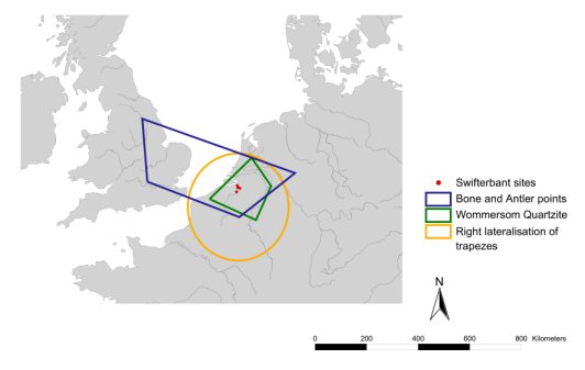
Figure 4: Material culture indications of social territories encompassing the Scheldt basin, as indicated by bone and antler points 11000-8500 BP (from Verhart 1990), Wommersom Quartzite (from Gendel 1984; Perdaen et al. in press), right lateralisation of trapezes (from Gendel 1987), and Swifterbant sites.
Over the past two decades, a key aim of research has been the demarcation of possible Mesolithic social territories within the broader areas encompassing the Scheldt basin. Studies range from raw material distributions (Crombé 2002; Crombé et al. in press; Gendel 1982; Perdaen et al. in press) to the relative regional frequencies of particular artefact 'styles' (Gendel 1984; 1987; Verhart 1990). Strikingly, none of these different studies are complementary across raw material and lithic 'style' distributions (Figure 4). For instance, Gendel's (1987) assessment of trapeze lateralisation demarcates a very large social territory between the Paris Basin, the Ardennes, and the North Sea; whereas Perdaen et al. (in press) note that Wommersom quartzite distributions in the later Mesolithic comprise a much smaller area of around 40,000 km². These differences underline the barriers to understanding the demarcations of social territories in prehistory, because not enough work has been carried out on the ethnoarchaeological significances and cultural meanings of raw material and material culture distributions. The ethnoarchaeological evidence cited above indicates the multiple scales of a 'social territory', and how systems of territoriality actually fall within the broader, more generalised cracks of social territories defined by material culture and raw material distributions. The only way to resolve this issue is a better understanding of the relationship between social interaction and cultural transmission in hunter-fisher-gatherer societies.
At the moment, the only clearly identifiable social territory in the Scheldt basin during the Mesolithic period is the Final Mesolithic Swifterbant culture (4600/4500-4100/4000 cal. BC), which arises after the arrival of the first agriculturalists. This period corresponds with complementary changes in the lithic industry alongside the introduction of pottery (Crombé et al. 2002; 2005; Sergant et al. 2006). Only four sites are attributed to this culture, which is located specifically in the marshy wetland areas of the lower Scheldt basin. It has, however, recently been suggested that the distribution of antler mattocks throughout both paleoecological regions of the Scheldt basin could have indicated the movements of Swifterbant people across the landscape and their exchange with agricultural populations (Crombé et al. 1999; 2005). The Swifterbant presence in the Scheldt basin indicates that hunter-fisher-gatherers were practising traditional Mesolithic ways of life for over a millennium after the arrival of the earliest agriculture (Crombé et al. 2002). What social and ecological processes caused this long delay in the transition to agriculture? Why are prehistorians not able to identify hunter-fisher-gatherer social territories during the first arrivals of agriculture to the Scheldt basin? These questions will form the focus of discussion.
© Internet Archaeology URL: http://intarch.ac.uk/journal/issue22/4/3_2.html
Last updated: Wed Oct 3 2007