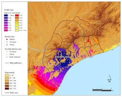
Figure 13: Fuzzy viewshed from a single viewer point (from Turó d'en Boscà hillfort)
Binary viewsheds fail to accommodate the fact that features visible from a particular location are seen less clearly as distance increases (Fisher 1994, 164; Wheatley and Gillings 2000, 11). In an attempt to characterise and quantify this phenomenon, the idea of dividing viewsheds into visual ranges has been put forward. However such approaches have rarely been applied within archaeological studies.
In seeking to address the question of falling visual clarity with distance, Fisher (1994, 165) suggested the fuzzy viewshed where values are graded from 1 near the viewer point to 0 at infinity (Figure 13).
Figure 13: Fuzzy viewshed from a single viewer point (from Turó d'en Boscà hillfort)
On the other hand, Wheatley and Gillings (2000, 15-17) presented the Higuchi viewshed, which has been implemented in one published archaeological study (Trick 2004). This method classifies a visible area into three bands, making use of visual indexes proposed by Higuchi. The first band, or short distance, should equal 60 times the size of the dominant tree species in the landscape, whereas the last band, or long distance, should start at a point equivalent to 1100 times the size of the tree. These bands are given meaning in terms of perception (for detailed discussion see Wheatley and Gillings 2000).
The potential of combining the probable and fuzzy viewsheds has been highlighted (Fisher 1994, 172-72; Wheatley and Gillings 2000, 11) and that possibility was considered within this study. However, the alternative of integrating probable and Higuchi viewsheds has been deemed more suitable to address the research questions of the project. Wide bands representing well-defined distances and established according to relevant criteria can be given meaning in terms of effectiveness of visual control. Consequently, they seem more appropriate than arbitrary graded distance bands for dealing with questions of visual control of the landscape.
Higuchi viewsheds have been created taking the most probable viewshed as input and then following the procedure described by Wheatley and Gillings (2000, 16-17). (Figure 14. See also the Higuchi viewsheds for every individual hillfort: Figures 19, 23, 27, 31, 35, 39, 43 and 47).
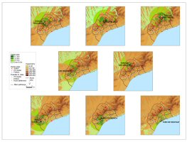
Figure 14: Higuchi viewsheds from the hillforts of the study area
The criteria for determining the Higuchi visual ranges have been adapted to the research needs. In particular the first Higuchi band, which would have resulted in roughly 180m (3m height of a tree x60), would not have served to address visual control or social identity issues, since there are not well-known Iberian sites that close to the hillforts. There are no precise rules for assessing radii of human visibility and different criteria can be found in GIS and archaeological literature (García Sanjuán et al. 2006, 185). Rather than relying on the formula proposed by Higuchi (and developed after all in the forested landscapes of rural Japan), I have followed some of the alternative suggestions. In practice, four visual ranges have been delineated:
© Internet Archaeology/Author(s) URL: http://intarch.ac.uk/journal/issue23/4/3.3.html
Last updated: Tues Mar 04 2008