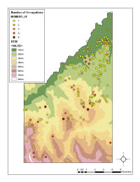
Figure 7: Distribution of Biferno valley survey findspots by number of occupations in the Larinum case study area.
A key issue in the use of legacy (survey) data is the degree to which data collected for one purpose can be used in the service of different research questions. In many cases, the original aims and methods mean that the data cannot be used in this way (see Chippendale 2000). For example, most pre-1980 surveys used the 'site' as the basic unit of record; it is therefore impossible to redeploy these data in order to address off-site activities such as manuring. None the less, there are still opportunities to explore recent theoretical concerns using legacy data, for example, visibility and viewshed studies have been particularly popular (e.g. Belcher et al. 1999).
Memory has formed a focus for much contemporary research within (landscape) archaeology. Individuals and groups within societies derive cultural memories from, or attach them to, elements within the landscape in order to negotiate identity and power (Alcock and van Dyke 2003). Older surveys often overlooked or dismissed the significance of such cross-temporal connections; maps of Roman settlement, for example, rarely include pre-Roman monuments which still stood in the landscape (Witcher 2006, 55). While much work on memory has concentrated on monuments, the archaeological landscapes of the Mediterranean are dominated by scatters of pottery derived from domestic and agricultural sites. However, these sites also serve to convey the historical depth and continuity of landscapes and people's relationships with them.
Table 5: Average number of occupations by findspot interpretation (Biferno valley survey)
| Interpretation | Number of findspots | Total number of occupations | Average number of occupations |
|---|---|---|---|
| Sporadic | 465 | 551 | 1.18 |
| Sporadic/Domestic | 8 | 14 | 1.75 |
| Domestic | 181 | 310 | 1.71 |
| Farmstead | 83 | 173 | 2.08 |
| Villa | 15 | 54 | 3.60 |
| Villa/Village | 5 | 22 | 4.40 |
| Village | 4 | 12 | 3.00 |
| Town | 3 | 13 | 4.33 |
Figure 7: Distribution of Biferno valley survey findspots by number of occupations in the Larinum case study area.
Again, simple visualisation techniques, such as plotting sites by the number of periods of occupation, can reveal informative alternative geographies. For example, in the lower Biferno valley, a series of well-dispersed, long-term settlement sites are surrounded by clusters of short-lived, single-phase, sites (Figure 7). This might suggest that the underlying social and economic structure of this landscape was more stable than the radical changes implied by settlement figures alone (Figure 8). These long-lived sites might be considered as stores of social memory and power, actively maintained by groups and individuals, perhaps even when other more suitable locations could be found. Further, the longest-lived sites tend to be higher up the settlement hierarchy (Table 5). This need not be the case; for example, villas might have been considered to be culturally intrusive and therefore vulnerable to wider economic and political shifts. Instead, the longevity of these sites suggests that they emerged from, and made cultural reference to, an existing system rather than being imposed upon it.
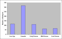
Figure 8: Graph of Biferno valley survey findspots by period in the Biferno valley.
Another approach to the cultural depth of landscapes is to explore issues of embodiment and experience (Witcher 1998). Across ancient Italy, a close relationship between topography and communication routes was common; frequently, tracks tended to follow ridges and watersheds (e.g. in South Etruria, Kahane et al. 1968). Around Larinum, a close relationship can also be observed between sites and elevated topographical locations (Figure 9). How was the experience of moving through this landscape structured by the relationship between topography, communication routes and the distribution of sites? In order to journey through this landscape, the DEM was processed to show the convexity (e.g. ridges) or concavity (e.g. valleys) of the landscape. The main ridge from the plain up to Larinum was then considered in terms of the sequence of findspots along its route (Figure 10). During the Roman period, travellers moving south from the plain up the ridge to the town would have moved through a landscape occupied by isolated rural settlements, before passing Monte Arcano, the focus of an extensive Iron Age and Samnite cemetery (Coarelli and La Regina 1993, 301; Di Niro 1991, 131). A series of low stone mounds (Barker and Suano 1995, 172) advertised the past function of the site, while its overgrown character indicated its antiquity. Continuing along the ridge, travellers passed through further areas devoted to agricultural activity, before passing another archaic necropolis of tumuli at Colle San Pietro. Not far beyond, immediately outside the town, were cemeteries of the 2nd/1st centuries BC. This area formed an extensive funerary zone throughout the late Samnite and Roman periods. Having passed the disused ancient cemeteries further down the ridge, this centralisation of contemporary funerary activity immediately outside the town's boundary (the agger), and its new monumental forms, were impressed upon the traveller. Old foci of veneration and political order were left physically and socially peripheral as formerly distinct activities (habitation, burial, ritual and monumentalisation) were centralised at Larinum. If the emergence of the town during the early Samnite period was associated with the dispersal of landscape activity (see Understanding Presence), the early Roman transformation of Larinum involved a concentration of social power reinforced through a re-centralisation of people and activities.
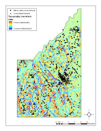
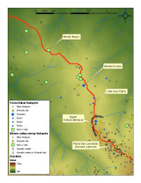
Figure 9: Distribution of findspots and topography (DEM curvature) in the Larinum case study area.
Figure 10: Movement along the main ridge from the plain to Larinum from north to south.
© Internet Archaeology/Author(s)
URL: http://intarch.ac.uk/journal/issue24/2/3.4.html
Last updated: Mon Jun 30 2008