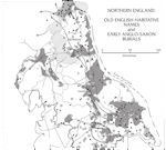
Figure 66: Old English habitation names and Early Anglo-Saxon burials (from Roberts 2008)
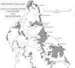
Figure 67: Anglo-Saxon stone sculpture and monasteries (from Roberts 2008)
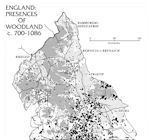
Figure 68: Presence of woodland AD 700-1086 (from Roberts 2008)
Far more is known regarding early medieval settlement patterns east of the Pennines than to the west, although as the above section illustrates, this may reflect the density of settlement as much as any underlying research priorities.
Figure 66: Old English habitation names and Early Anglo-Saxon burials (from Roberts 2008)
Figure 67: Anglo-Saxon stone sculpture and monasteries (from Roberts 2008)
Figure 68: Presence of woodland AD 700-1086 (from Roberts 2008)
The mapping of undated crop marks in both the Vale of York and parts of the Yorkshire Wolds has shown varying but extensive settlement, much of which is of possible early medieval date (Richards 2000, 36, figs 4.10 and 4.11). In the Vale of York these are mostly located some distance from the main river channels of the Ouse and Derwent on slightly higher ground, although post-Roman flooding may be a factor in settlement visibility (Van de Noort 2000, 129). On a broader scale, there are too few excavated Anglo-Saxon settlements to assess distribution patterns, but 5th to 8th-century burials and cemeteries in the north of England may give some indication. Lucy's (1999, 16-20) work on burial east of the Pennines has shown very little material known north of the Tyne or between the Tees and the Derwent (Fig. 66). More extensive evidence comes from between the Tees and the Tyne, within a 25km zone along the coast, but the region's major concentration of burial evidence comes from East Yorkshire, mostly on the Wolds. Higham (2004, 25) has stated that 5th to 7th-century burial sites west of the Pennines are virtually non-existent, but pre-Viking settlement patterns can in part be sketched through study of pre-English place-names. These are mostly confined to areas below 300m OD and there are few known from the Mersey Plain (Higham 2004, fig. 11).
The distribution of pre-Viking ecclesiastical foundations in northern England is also of interest. Morris (1989, fig. 25) shows through the combined evidence of stone sculpture, written sources and place-names that these sites follow the general settlement patterns as suggested by Higham (1987) (Fig. 67). He identifies large numbers of religious sites east of the Pennines, especially from the Vale of York northwards towards Bishop Auckland, mostly following the Roman roads; along the western and northern edges of the Yorkshire Wolds; more sparsely distributed along the coastlines from North Yorkshire to Lindisfarne; and from the east coast towards Hexham along the Roman road network. West of the Pennines far fewer foundations are known, although a small concentration in the Lancaster area is visible. Blair (2005, 193) has also noted that most minsters appear to be located near water, although in Northumbria it is apparent that overland routes were also a focus (Hill 1966, cited in Blair 2005, 194n). Alongside this, Anglo-Scandinavian place-name evidence (e.g. Loyn 1977, map 4; Higham 2004, fig. 14) provides some of the most extensive data available for pre-Conquest settlement patterns. This shows again that the lowlands and river valleys probably represent areas of densest occupation, especially from the Vale of York to the Tees Valley, the Yorkshire Wolds and the coastline from the mouth of the Tees to Whitby. The lowlands of Lancashire and Cumbria/Westmorland have the highest level of Anglo-Scandinavian place-name survival west of the Pennines. A line of trans-Pennine settlement lies along the slightly lower ground (below 300m OD) between Harrogate and Burnley. The upland areas of County Durham and Northumberland are more sparsely covered.
The overall pattern produced by these sources of evidence suggests that the south-east of northern England, encompassing the Vale of York, the Yorkshire Wolds and parts of the Tees Valley, may be the area of historically densest settlement. West of the Pennines was also well populated but probably not to the same extent. The eastern area north of the Tees, and especially north of the Tyne, shows the sparsest settlement patterns, although the archaeological evidence from sites such as Yeavering and Millfield are indicative of a larger potential population. Roberts (Fig. 68) has used the combined evidence to suggest a number of 'cultural cores' in northern England. These he describes as 'land largely lacking recorded woodland in both 1086 and in the form of Old English place-names representing anciently cleared long-filled land and settlement cores'. They are centred on the Yorkshire Wolds, northern Vale of York, the region between the Rivers Tees and Tyne, the coastal zone of Northumberland and patches of northern Cumbria (no attempt was made to define zones in Lancashire). These tend to follow lowland areas, coastal zones, major river valleys, and regions of high agricultural potential, such as the Yorkshire Wolds, and it is unsurprising that these would eventually form settlement cores. In this form, however, Roberts' mapping provides an extremely useful comparative element.
© Internet Archaeology/Author(s)
URL: http://intarch.ac.uk/journal/issue25/2/3.3.1.1.html
Last updated: Tues Apr 21 2009