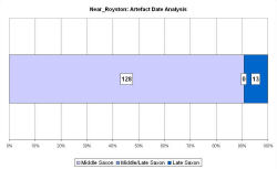
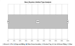
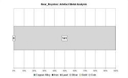
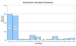
Fingerprint charts for i) artefact date analysis, ii) artefact type analysis, iii) artefact metal analysis and iv) coins – date of production
The settlement at Royston grew up at the intersection of Ermine Street and the Icknield Way, a major crossroads in Middle Anglia. It is situated in the northern slopes of the Hertfordshire chalk downs, c. 20km north-east of Cambridge.
The 'productive site' known as 'Near Royston' is a large field on the Cambridgeshire/Hertfordshire border, which has been metal-detected since 1979. The VASLE dataset is derived from the EMC only. Over 100 coins have been found, 35 of which are continental, dating from the 7th and the first half of the 8th century. There is continuity of coin loss through the 9th-11th centuries, although at a much reduced level. The site has a similar coin graph to Hamwic and Tilbury, but with a revival in the 10th century with a group of Viking and later issues. Although there has been no archaeological survey work, the site has been interpreted as a seasonal market serving local estates.
Fingerprint charts for i) artefact date analysis, ii) artefact type analysis, iii) artefact metal analysis and iv) coins – date of production
© Internet Archaeology/Author(s)
URL: http://intarch.ac.uk/journal/issue25/2/4.4.41.html
Last updated: Tues Apr 21 2009