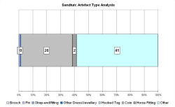
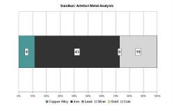
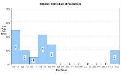
Fingerprint charts for i) artefact date analysis, ii) artefact type analysis, iii) artefact metal analysis and iv) coins – date of production

Reference: Gardiner et al. 2001
Archives:
http://ads.ahds.ac.uk/catalogue/search/fr.cfm?rcn=EHNMR-638922
http://ads.ahds.ac.uk/catalogue/search/fr.cfm?rcn=EHNMR-1074149
Dykeside Farm is situated on sand dunes at the north-eastern edge of Romney Marsh, c. 600m north-west of the Saxon shore fort at Lypmne. A number of excavations have taken place at West Hythe since 1947-8, when unpublished excavations produced evidence of two phases of occupation, dated to the Middle Saxon and Anglo-Norman periods. Finds included hearths, metalwork (fish-hooks, shares, pins, seaxes), fish and animal bones, and pottery. The VASLE dataset is derived from the published excavation report.
Further fieldwork in 1993 located a boundary ditch that had been recut twice in the Middle Saxon period, although no structural remains were found. An impressive finds assemblage was recovered: imported pottery accounted for 30% of the ceramics, and there was evidence for fishing and craft-working in textiles and leather.
The excavated site at Dykeside Farm has been equated with the Old English place name Sandtun, which was first used in a land grant of 732 from Æthelberht II of Kent to the Abbot of Lyminge. This gave the Minster the right to produce salt, and a further charter of 833 mentions salt pans in the area (Gardiner et al. 2001, 166). Gardiner's interpretation indicates a broadly based settlement, with salt production, fishing, and small-scale craft production, as well as coastal trade. He argues that the amount of imported pottery implies direct contact with the Continent, rather than redistribution from a wic. Therefore the site provides evidence for the involvement of a lower tier of settlements in networks of continental trade.
Fingerprint charts for i) artefact date analysis, ii) artefact type analysis, iii) artefact metal analysis and iv) coins – date of production
© Internet Archaeology/Author(s)
URL: http://intarch.ac.uk/journal/issue25/2/4.4.50.html
Last updated: Tues Apr 21 2009