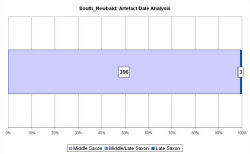
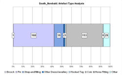
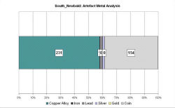
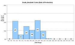
Fingerprint charts for i) artefact date analysis, ii) artefact type analysis, iii) artefact metal analysis and iv) coins – date of production
South Newbald is located on the western edge of the Wolds, c. 100m east of the Roman road that runs north from the Humber, and which branches 800m south of the detected area.
Metal-detecting since c. 1983 over 30,000m² has produced large numbers of coins dated c. 740-855 and large amounts of copper alloy metalwork, but no domestic material. Coins from the site were originally published by Booth and Blowers as coming from Sancton. Material has been recovered over a ten-year period, concentrated in an area c. 120m square. The VASLE dataset was compiled by Dave Haldenby.
A Roman villa lies in an adjacent field and there are also Early Saxon cemeteries nearby. Eighteen unaccompanied skeletons were found in the field that contains the site. There is also documentary evidence for an Anglo-Scandinavian royal estate in Newbald, and the current parish boundary bisects the site, supporting the idea that it held some central market function.
Fingerprint charts for i) artefact date analysis, ii) artefact type analysis, iii) artefact metal analysis and iv) coins – date of production
© Internet Archaeology/Author(s)
URL: http://intarch.ac.uk/journal/issue25/2/4.4.55.html
Last updated: Tues Apr 21 2009