Figure 18: Villa de Chantal, door sill in situ
Figure 18: Villa de Chantal, door sill in situ
The known villa of Chantal at Les Mazilles was initially investigated in the 2000 pilot season, in order to test how well geophysical survey would detect Gallo-Roman buildings, with further work in subsequent years. The principal record of the 19th-century excavation is a photographic plate showing a detailed plan of two ranges of buildings and a large basin, together with a section across the east range into the basin (Roidot-Deléage nd, partly reproduced in Rebourg 1993, 211; Fig. 17). The plan gives the impression of being accurate and detailed, although the actual extent of the buildings is not precise, as our surveys demonstrated. A few artefacts from the excavations are now in the Musée Rolin in Autun, including a lamp (Firmalampen type, T GELLI with a laurel wreath; Carré 1984, no. 54).
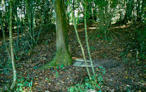
The southern range now lies under a narrow strip of woodland, where it survives as a significant raised earthwork. In the central part of the coppice the remains of the old excavations, not entirely backfilled, can be made out, and a door-sill, marked on the excavation plan (F), can still be seen in situ (Fig. 18). From here the ground dips steeply down into the basin identified by Bulliot. The surviving earthworks in the wood suggested the southern range of the building actually extended slightly further than his plan allowed, and indeed the width of the range appears to broaden at the end rather than narrow.

Resistivity and high-resolution gradiometry took place on either side of the wood to determine the extent of the villa. The resistivity clearly showed the shape and form of the rectangular basin on the eastern side of the villa, overlooking the river (c. 62 x 42m) (Fig. 21), which had extremely well-defined edges. However, elsewhere the technique did not show the villa walls. From the earlier excavations we know that the walls do survive to a significant degree, so the failure may result from either conducting the survey at too low a resolution, or, more likely, that the soil conditions in the high summer meant that the ground was too dry to give good results. Only areas where there was significant moisture retention (such as in the lined basin) were liable to give satisfactory results.
The high-resolution gradiometry gave better results although, owing to the nature of the subsoil, the walls were not exceptionally clear (Fig. 20). It is possible to make out some detail in the plan, but not all the walls. Nonetheless the overall shape of the courtyard villa can be established with some confidence (Fig. 19). This revealed that the eastern range was longer than Bulliot's plan indicated, and there was in addition a northern range, creating a three-sided courtyard. Bulliot suggested evidence for a small separate building in the middle of what would have been the western edge, but no clear trace of this was visible in the geophysical results.
Some small-scale micro-topographic work was carried out by Fabrice Laudrin to record traces of the building platforms, which are still faintly visible in the field to the north of the wood (Fig. 22). These correlated directly with the ranges as revealed by the geophysics.
Geophysical survey in the field immediately south of the wood revealed further traces of occupation, including areas of possible building remains on the terrace 80m south of the south range of the villa (Les Mazilles south). The magnetic responses are too vague to identify clear building plans, but those alignments that could be seen are all on a different orientation from that of the villa.
The pottery
No. of sherds: 41; total weight: 174g
A sample of ceramics was collected from over the south building range in the wood and from molehills in the surveyed fields. The assemblage included little in the way of diagnostic sherds. This may be a product both of the restricted area examined and the poor conditions for collection. Only one form can be closely assigned, probably to the 1st century AD (Fig. 78, 1). A few coarseware sherds in fabric B2 may indicate late La Tène or early Roman occupation but represent a small component of the assemblage. A range of Gallo-Roman grey wares and flagon fabrics and forms were present, but cannot be closely dated (Fig. 78, 3). The lack of diagnostic amphora is notable, as is the small amount of Terra Sigillata (Section 6.4, TS23). To what extent this can be regarded as indicative of the date and nature of occupation is unclear; a further group collected from just across the road (Chantal west below) does contain elements of 2nd-century occupation. Some of the Roman finds recovered in other fields around the villa may relate to its use or to peripheral buildings or activity areas, but do not significantly alter this picture.
| Stray finds from the wood and from molehills | 10, 23 | Fig. 78 Diagnostic ceramics |
| Gradiometry Survey: 0.5m x 0.25m (4.68 ha) | 11, 12, 24, 26, 50 | Fig. 20 Gradiometry results Fig. 19 Gradiometry interpretation |
| Resistivity Survey: 1.0m x 1.0m (4.59 ha) | 13, 14, 25, 51 | Fig. 21 Resistivity results Fig. 19 Resistivity interpretation |
A concentration of Roman pottery and tile, including tegulae, was found in a small cultivated field on the opposite side of the road to the west of Les Mazilles, on a continuation of the alignment of the southern range of the villa. This suggests that the villa complex extended further west, perhaps in the form of ancillary structures axially aligned to the main courtyard. Discussion with the farmer also suggested that there was an old spring in the field, possibly piped. The field was walked twice (UF 27, 65), but both times was largely covered either by weeds or a buckwheat crop, significantly limiting recovery.
The pottery
No. of sherds: 53; total weight: 313.8g
The assemblage includes a substantial amount of fabrics W3-W6 usually found in flagon forms and Gallo-Roman grey and coarsewares (Fig. 78, 4, 5, 6). Again, little material is diagnostic, with few identifiable forms. A handful of coarseware sherds in fabrics B2 and R4 (Table 4) give the impression of early (possibly even late Iron Age), occupation, while the strong representation of flagon fabric is consistent with 1st-century AD activity. A single sherd of samian dates to the late 1st/early 2nd century AD (Section 6.4, TS31). One P(AV)11.2 (Fig. 78, 2) can be suggested as 2nd century AD on the basis of parallels from Autun.
| Stray finds | 27 | No diagnostic ceramic forms |
| Line walked: 10m transects (1.35 ha) | 65 | Fig. 78 Diagnostic ceramics |
© Internet Archaeology/Author(s)
URL: http://intarch.ac.uk/journal/issue25/3/5.1.1.html
Last updated: Wed Oct 29 2008