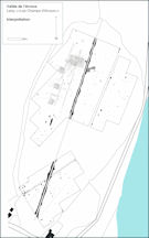
Figure 51: Interpretation of landscape around the Champs d'Arroux
Figure 51: Interpretation of landscape around the Champs d'Arroux
The geophysical results obtained from the low-lying and apparently unpromising pasture field known as Les Champs d'Arroux turned out to be the best of the survey. Niaux (1991-2) reported finding material both at Les Places, just north of Les Champs d'Arroux, at the northern end of the field, and at Bas Cernat at its southern end, but apparently nothing between the two.
In the northern part of Les Champs d'Arroux, geophysical survey in 2002 indicated the existence of a substantial Gallo-Roman establishment with a remarkably clear plan covering at least 1 ha. The main complex of rooms coincides with a slight mound visible in the field. A long wall runs south from here, with a series of small three-celled structures positioned to the west of it. These bear some resemblance to buildings on other large Gallo-Roman sites known from aerial reconnaissance in northern Burgundy, such as Asquins, La Chapelle-Vaupelteigne (l.d. Le Sureau), Laignes, and Sainte Pallaye, all in Yonne (B. Bonnamour, pers. comm.; Nouvel 2004; Fig. 52). Visibility to the east of the gas pipeline is nowhere near as good, especially in the area nearest the river surveyed in the hot summer of 2003, but faint traces of the building complex are nonetheless apparent.
The middle of the field was covered in tussocky grass and was not surveyed - even in the drought summers of 2002 and 2003 it remained boggy - but a second survey was undertaken in the southern part of Les Champs d'Arroux, close to Bas Cernat. This revealed further possible archaeological features close to the western boundary of the field, but the results here were not particularly clear. The survey area was bisected by a modern field ditch; this continues out of the field to the south-west, where it turns south to form the eastern edge of a small triangular wood. At the apex of the Bas Cernat wood, just beyond the survey area, a layer of Gallo-Roman tile was observed, 0.5m down, in the side of the ditch, with the remains of a probable wall at its southern end. A quantity of pottery and tegulae were recovered from the ditch at this point and also further along its course.
The part of the gradiometry survey closest to the wood revealed a higher than background level of metal spikes, but no evidence of buildings. The focus of this second site may well therefore lie in the wood, an impression reinforced by the discovery of a further group of sherds beside a footbridge spanning a small stream on the western side of the wood. It is possible that the finds reported by Niaux at Bas Cernat were from the wood rather than the gas pipeline, which passes immediately to the east.
Unfortunately the only finds from molehills over the main Gallo-Roman building complex were four undiagnostic sherds (8g) and a piece of tegula.
The pottery from Bas Cernat (UF 78)
No. of sherds: 51; weight: 333g
The few diagnostic sherds in this group are of 1st to 3rd century AD date (Fig. 92, 91, 94, 95). A number of other sherds have 1st-century AD parallels (Fig. 92, 89, 90, 97), perhaps suggesting that the main focus of activity was between the 1st and 2nd centuries AD.
| Gradiometry survey: 1.0m x 0.5m (3.42 ha) Gradiometry survey: 0.5m x 0.25m (3.87 ha) Resistivity survey: 1.0m x 1.0m (0.72 ha) |
67*, 74 69, 86* 68 |
Fig. 53 Gradiometry results Fig. 54 Resistivity results Fig. 51 Geophysics interpretation *Note: material collected during geophysics was recorded as 67 and 86. |
| Stray finds from the edge of Bas-Cernat wood | 78 | Fig. 92 Diagnostic ceramics |
To the west of Les Champs d'Arroux, between it and the modern farm, three further blocks were surveyed by magnetometry in Champs de la Lie, an area of low-lying pasture with a small stream running through it. One area contained a few indistinct anomalies, but the results were otherwise negative. The stream echoes the curving boundary around the Champs d'Arroux, and may indicate a former branch of the river. Indeed it is possible that Les Champs d'Arroux was once an island or dry area in the floodplain, as is still the case just over 1km downstream near Chazeu.
A single sherd of pottery (18g) in the probable late fabric B4a was recovered during the geophysical survey in 87.
| Gradiometry survey: 1.0m x 0.5m (3.08 ha) | 87, 88, 89 | Fig. 55 Gradiometry results
Fig. 56 Gradiometry interpretation |
© Internet Archaeology/Author(s)
URL: http://intarch.ac.uk/journal/issue25/3/5.3.1.html
Last updated: Wed Oct 29 2008