Figure 1: Yiluo River Basin, Henan Province, China
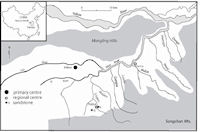
The site of Huizui is located in the Yiluo River Basin of western Henan Province (Fig. 1). It has a long history, dating from the Middle Neolithic through to the Early Bronze Age. The site is divided into two parts by a large gully. During the Neolithic period, occupation was limited to the eastern side of the gully. However, during the Erlitou period, when the site was at its largest size of 25 hectares, both the western and eastern sides of the gully were occupied.
Figure 1: Yiluo River Basin, Henan Province, China
Huizui was originally surveyed and excavated by the Liu Hulan team in 1959 (Henan Cultural Bureau 1961). The excavation was located in the eastern section of the site and measured approximately 300m². A total of 130 stone artefacts were recovered from this excavation: 71 dating to the Erlitou period, 55 to the Longshan period and three to the Yangshao period (Ford 2001).
In 2001, the Yiluo River Valley Archaeological Project resurveyed the site and collected 442 stone artefacts. These artefacts were gathered from the surface and walls of the agricultural terraces, where the local farmers had placed them after removing them from their fields. Because they had been removed from their original context, dating these artefacts was difficult. Although it appears that the artefacts recovered from the eastern section of the site were most likely from eroded Erlitou layers, these artefacts were considered indeterminate in age. The western section of the site was only occupied during the Erlitou period and the artefacts recovered from here have therefore been attributed to this period. The 2001 and 1959 assemblages were originally analysed as part of a previous study by the author (see Ford 2001; 2004), which focused on identifying what stone tools were manufactured at Huizui, detailing their reduction sequences, and investigating how stone tool production at Huizui related to the regional Erlitou economy.
In 2002, the Yiluo River Valley Archaeological Project began excavations at Huizui. During this season, the western part of the site became a focal point as it potentially had the most evidence for stone tool production dating to the Erlitou period. Using survey, terrace screening and shovel tests, a stone tool production area was identified (Fig. 2), primarily located within an apple orchard. This orchard sits on a higher terrace than the surrounding area and therefore has not been excavated for agricultural purposes as has occurred in other places at Huizui, so in part preserving the Erlitou deposits.
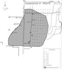
Figure 2: Stone tool production area at Huizui West
Two 1 x 1 metre test pits were excavated in the apple orchard, in areas where significant flake clusters were identified during the terrace screening (Fig. 2). Based on associated ceramics, both test pits were dated to the second period of the Erlitou culture (Erlitou II), approximately 1800 - 1700 BC. Both contained evidence for stone tool manufacture, including large amounts of oolitic dolomite manufacturing debris. However, the nature of deposits in both the test pits is significantly different, suggesting differences in use.
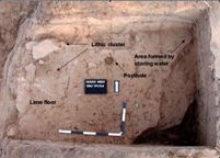
Figure 3: Stone tool manufacturing loci in Test Pit 1, Huizui West
Test Pit 1 was excavated to a total depth of between 0.47-0.50 metres. The main area of stone tool production occurred at a depth between 0.35 to 0.50 metres. Within this context, a small stone tool manufacturing loci was excavated (Fig. 3). Located in the western section of the test pit, this small area consisted of eight oolitic dolomite spade tool blanks, eight broken feldspathic sandstone grinding slab fragments and large amounts of manufacturing debris. In total, the context associated with the stone tool production area consisted of eleven oolitic dolomite spade tool blanks, ten broken feldspathic sandstone grinding slab fragments and 5749 pieces of manufacturing debris. Of the manufacturing debris, the main raw materials represented were oolitic dolomite and feldspathic sandstone (see Table 5).
Underlying these artefacts was a lime floor, which extends from the northern part of the test pit to halfway across the middle of the test pit before it breaks away. A post-hole was located in the middle of this lime floor, suggesting that this area may once have been a covered structure. In the north-eastern corner of the test pit, a yellow-grey soil deposit occurred, which may indicate that this area was used to contain standing water (Rosen pers. comm.). This could have been used as a basin for holding water used in the grinding stage of the manufacturing process (Fig. 3).
From the above structural remains and artefact assemblage, it would appear that the area represented in Test Pit 1 was a stone tool production area, specialising in the production of oolitic dolomite spades. Manufacturing activities represented within the production area include flaking, grinding and polishing shown by the presence of different manufacturing techniques on the surface of the tool blanks and the manufacturing debris, and also by the presence of the grinding slabs. Of the manufacturing debris, 24 flakes had evidence of polish and 35 flakes had evidence of grinding.
In contrast to Test Pit 1, Test Pit 2 consisted primarily of a very large amount of manufacturing debris, composed in the main of oolitic dolomite flakes (Fig. 4). In the sample analysed, which included approximately half of the total assemblage, 8413 pieces of manufacturing debris were present. Very few of these flakes show any evidence of other types of manufacture, with only six flakes showing evidence for hammer dressing and seven flakes showing evidence for grinding. This would suggest that flaking was the predominant manufacturing activity that occurred in the vicinity.
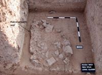
Figure 4: Oolitic dolomite flaking debris in Test Pit 2, Huizui West
A small amount of tool blanks and finished tools were also within the assemblage but these were all broken. Based on the lack of structure to Test Pit 2 and the large amount of manufacturing debris, it would appear that this area is a refuse deposit for a manufacturing area. A hardened context which is associated with the flake deposit and located in the northern part of the test pit, may be evidence of a wall against which the flakes may have piled up as they were dumped.
Within these two test pits, there would therefore appear to be two very different types of manufacturing areas depicted. The first, Test Pit 1, is a stone tool production area, complete with structural remains. The second, Test Pit 2, is a refuse dump that may have lain outside a wall, although it is unclear whether this was a fence or a structure.
In addition to the test pits, shovel tests were completed within the stone tool production area (Figure 2), where cultural deposits ranged in depth, with the maximum one metre deep. The deepest cultural deposits were present within the apple orchard. The shovel tests were placed in every second row between the apple trees (north to south), at approximately 12 metre intervals, with each shovel test 10 metres along the row from each other (west to east). Shovel tests were then completed in the lower surrounding terraces to identify depth and extent of the cultural deposits. All of the assemblages were analysed in their entirety except for Test Pit 2, which was sampled because of the massive amount of material recovered. This sampling strategy resulted in all finished tools and tool blanks being analysed and approximately half of the manufacturing debris within this test pit. Table 1 shows the quantities of each type of material present within the different assemblages. From this table, it can be seen that the composition of the different assemblages is highly variable. This is probably the result of the different research strategies employed at the site, with the surveys resulting in mostly larger items such as tool blanks and finished tools, while the finer detailed excavations produced more manufacturing debris. This is especially highlighted in Figure 5, which shows the relative frequency of each artefact type across the different assemblages.
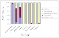
Figure 5: Relative values for stone artefact types within assemblages
As the assemblages are highly variable in nature, focusing on each assemblage separately would provide very different pictures as to the overall nature of stone tool production at Huizui. For example, if only the 2001 or 2002 survey collections were analysed, a large number of tool blanks would be present but no other evidence for manufacture. It was therefore decided to analyse all of the assemblages collectively, thus examining all of the finished tools from the assemblages together, all of the manufacturing debris together and so on. This will enable a more complete view of the on-site stone tool production at Huizui as it provides information from all the different types of data present at Huizui.
© Internet Archaeology/Author(s) URL: http://intarch.ac.uk/journal/issue26/15/5.html
Last updated: Wed Jul 1 2009