Figure 1: Location map
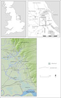
The area examined here is a landscape block with its corners at NGR SE 950250, SE950540, SE730540, and SE730250, which contains the whole catchment of the River Foulness, located in the eastern Vale of York, north of the River Humber in the East Riding of Yorkshire. In the northern and eastern edges of the study area are the Chalk uplands of the Yorkshire Wolds, running south-east to north-west (Fig. 1).
Figure 1: Location map
The southern Yorkshire Wolds form a ridge of exposed Chalk upland, 8-10km wide, which runs north-south and is distinct from the mass of the northern and eastern Yorkshire Wolds, where most of the archaeological attention in the region has been concentrated in the past (Mortimer 1905; Manby 1988; Manby et al. 2003). To the west of the Wolds is the narrow Lias bench, which gives its name to the villages of North and South Cliffe. The terrain to the west of the Lias bench is relatively flat, only interrupted by Church Hill, Holme-on-Spalding Moor, an outlier of Triassic Mercia Mudstone (Fig. 2a).
The region under scrutiny can be subdivided into three zones on the basis of topography, soils (King and Bradley 1987; Furness and King 1978), and drainage (Fig. 2):
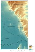
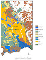
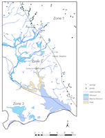
Figure 2: a. Topography b. Soils c. Watercourses and drainage
The contrasting surface geology and topography between these zones provides a convenient background against which differences in human-landscape interaction can be examined and compared. The prehistoric archaeology of the Yorkshire Wolds, the most important landscape feature of Zone 1, is well known through the work of Greenwell (Greenwell and Rolleston 1877) and Mortimer (1905) and Manby (1988; Manby et al. 2003). In prehistory this higher, drier ground contained much less landscape contrast than the valley lowlands. Before the Humber Wetlands project (Van de Noort and Ellis 1999; Van de Noort 2004) and the Foulness valley research project (Halkon 2003; Halkon and Innes 2005), little attention had been paid to the Neolithic in the lowlands of the Vale of York, apart from a general survey by Radley (1974). In the Vale of Pickering around West Heslerton (Powlesland 2003), a broadly similar survey to the one discussed here has examined past human activity within the contrasting terrains of chalk uplands, sandy foothills and wetlands in the north of the former East Riding of Yorkshire.
Some caution must be deployed when interpreting the distribution of finds within the Foulness Valley. The higher parts of the sandy ridges such as those in Zone 2 above are more vulnerable to ploughing and are therefore more likely to yield surface finds than low-lying areas, such as Zone 3, where sites and artefacts may lie under alluvium and have therefore been protected from the plough (Fig. 2b and 2c). Although such areas have been shown to have great archaeological potential (Needham and Macklin 1992; Davies and Van de Noort 1993) it is clear, however, that at some times raised sea-level or water table may have rendered them uninhabitable, the better-drained sand ridges being more favoured for settlement and farming.
© Internet Archaeology/Author(s) URL: http://intarch.ac.uk/journal/issue26/12/2.html
Last updated: Wed Jul 1 2009