PREVIOUS
NEXT
CONTENTS
HOME
1. The Geographical, Geological and Archaeological Context
During the last five years, intensive research has been conducted in what appears to be one of the main prehistoric axe production centres of southern India (Boivin et al. 2005; 2007; Brumm et al. 2006; 2007; Fuller et al. 2007). The Sanganakallu-Kupgal archaeological complex, which includes several settlements, ashmounds, quarry sites and other activity areas, is located 6km east of the modern town of Bellary, in the centre of the Deccan plateau (Fig. 1). This region is characterised by semi-arid environmental conditions in the monsoon climatic belt, and such conditions were established by the third millennium BCE (Fuller and Korisettar 2004). The region came to the notice of Western scholars at the end of the 19th century owing to the occurrence of extreme famine under the Victorian occupation, which led to the starvation of 11 million persons (Davis 2001). The very dry region is at the heart of the earliest known Neolithic cultural sphere in peninsular India, where ceramics and ground stone tools are reported from as early as 3000 BCE (Korisettar et al. 2001a), and archaeobotanical evidence indicates cultivation of indigenous food plants alongside herding of introduced livestock during the third millennium BCE (Allchin 1963; Korisettar et al. 2001b; Fuller et al. 2004). The Neolithic culture in this area is characterised by distinctive ashmound sites, which feature thick accumulations of ash thought to derive from the burning of dung at seasonal cattle-penning sites, perhaps as part of ritual cycles (Allchin 1963; Korisettar et al. 2001a; Boivin 2004a; Johansen 2004).
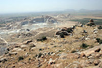
Figure 1: The three hills of the Sanganakallu-Kupgal complex. In the foreground is Hiregudda, taken from Area C, where quarrying of the upper reaches of the dolerite dyke was carried out, and looking down onto Area A, where stone tool manufacture was carried out. The hill being heavily quarried today for granite is Choudammagudda. Sannarachammagudda can be seen beyond it. The modern village of Sanganakallu is visible in the upper left, while the town of Bellary can be seen in the middle distance. (Photograph by J.A. Soldevilla)
The geological record in the Bellary district is mainly Pre-Cambrian in age and the rocks occurring can be divided broadly into three types: a) the gneisses and granites belonging to Peninsular Gneissic Complex (PGC), which are the oldest rocks and constitute the basement, b) the schistose rocks of Dharwarian age comprise both sedimentary and volcanic low-grade metamorphic rocks, and c) the younger Closepet Granite, which shows an intrusive relationship with both previous formations. In addition, different basic dykes of gabbro and dolerite rocks from Proterozoic age were probably emplaced following deep fractures in PGC and Closepet granite during the first steps of deformation, recorded in the shists as anticlines and synclines fold structures.
From a geological perspective, the Sanganakallu area is situated in the younger Archaean granitic formation (Dharwar batholith). The granitic bedrock emerges as inselbergs in the ancient floodplain. Frequent quartz and pegmatite veins and basic dykes of post-Archaean formation traverse these granites, mainly in a north-west/south-east to west-east direction. The size and composition of these dykes is highly variable. One of the dykes, which crosses part of the Hiregudda inselberg (the largest hill in the Sanganakallu-Kupgal complex), 1.5km north-east of the modern village of Sanganakallu, was the focus of intensive prehistoric quarrying and axe blank production. The dolerite outcrop is about 700m long and varies between approximately 10-30m wide. Masses of manufacturing debris cover its surface over at least 500m of its course, practically from the plain at the south-eastern foot of Hiregudda (450m asl), continuing in a north-west direction uphill to a height of 560m asl. Three other dykes also traverse Hiregudda, but do not appear to have been quarried (see Fig. 2).
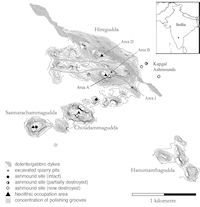
Figure 2: Map of the Sanganakallu-Kupgal archaeological complex. The grey shading indicates the location of the dolerite dykes on Hiregudda, which total four in number. The quarried dyke runs from Area J in the south-east to Area B in the north-west
The first notice of the exceptional quarry area at Hiregudda dates back to the observations of the British geologist, Robert Bruce Foote, at the end of the 19th century (Foote 1887; 1916), with subsequent explorations in the mid-20th century (Subbarao 1948; see Korisettar et al. 2001a). Foote referred to it as 'the most important neolithic settlement in the country' and 'the site of the largest neolithic manufacturing industry as yet met with in any part of India' (1916, 82). Recent work continues to illustrate its importance. Nonetheless, little research was carried out at Hiregudda subsequent to Foote's explorations, in part because the neighbouring site of Sannarachammagudda became a focus of investigation (Ansari and Rao 1969; Subbarao 1947; 1948). Renewed work was thus initiated at the site in 1997. Test excavations and sampling aimed at chronological placement and reconstructing subsistence were carried out in 1998 in Hiregudda Area A (Korisettar et al. 2001b; Fuller et al. 2004). Larger scale systematic excavation and mapping was carried out between 2003 and 2006, when several trial trenches were excavated in the upper and the lower parts of the dyke, named Hiregudda Area B and Area J respectively (Boivin et al. 2005). More than 95% of the material recovered from the resultant trenches consisted of dolerite shatter and waste flakes. Axe blanks, hammer stones and a few horn tools also provide information about the activities carried at these quarries, as discussed below.
Close to the quarry, on the natural terraces extending across the top of Hiregudda, at least three settlement areas of c. 0.5-1 ha size and one ashmound were located. Excavations carried out in two of these areas (Areas A and D), one of which included the ashmound, confirm that these habitation and activity areas were, to a large extent, contemporary with the quarry (Boivin et al. 2005; Fuller et al. 2007).
Two additional settlements greater than 1 ha in size were identified on the granitic hills called Choudammagudda and Sannarachammagudda, located 700m and 1400m south-west of the quarry, and also form part of the Sanganakallu-Kupgal complex. While the first has only been investigated as part of one recent field season, Sannarachammagudda and its ashmound have been the target of archaeological research since the 1940s and represent one of the key stratigraphies for the later prehistory of southern India (Subbarrao 1948; Ansari and Nagaraja 1969; Korisettar et al. 2001b; Fuller et al. 2007). On both sites, the presence of axe blanks, dolerite debitage and different percussion and polishing tools leave little doubt that the inhabitants of both settlements were involved in axe production.
At this point in time, no radiocarbon ages are available for the quarry areas, but the dating programme carried out at the habitation sites of Hiregudda and Sannarachammagudda provide ages that indicate Neolithic occupation beginning at around 1950 cal BCE (Fuller et al. 2007). Although axe manufacture formed part of the local economy from the beginning, the intensity of production underwent important variations over the centuries. After c. 1100/1000 cal BCE the settlements were apparently abandoned, and evidence from later occupations is scarce. The excellent preservation of the archaeological record, and the quantity and variety of means of production present on the settlement and quarry areas makes the Sanganakallu archaeological complex attractive for the study of social and economic organisation and prehistoric axe production.
PREVIOUS
NEXT
CONTENTS
HOME
© Internet Archaeology/Author(s) URL: http://intarch.ac.uk/journal/issue26/26/1.html
Last updated: Wed Jul 29 2009