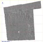
Figure 2: Heslerton Site 28 geophysical survey results presented as a greyscale image.
Figure 2: Heslerton Site 28 geophysical survey results presented as a greyscale image.
A geophysical survey, using a Geoscan FM36 fluxgate gradiometer was undertaken by James Lyall, Kathryn Day and Maria Beck of the LRC. An initial sample along the eastern boundary of the field was surveyed to identify suitable areas for excavation, and the survey was then extended to cover the whole field (Fig. 2). Geophysical data was collected at a sample density of .25*1.0 metres in 30m grids; and a high-resolution survey of Trench 28AA, at a sample density of .25*.25 metres, was undertaken after removal of the ploughsoil.
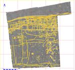
Figure 3: Heslerton Site 28 geophysical survey results presented as a greyscale image overlain with identified anomalies digitised in yellow.
The geophysical survey revealed an unanticipated wealth of archaeological features beneath what on the surface appears to be a featureless field. The individual anomalies were digitised and presented as a colour overlay (Fig. 3). The northern part of the area, which appears as an area of flat grey, reflects the falloff in archaeological activity beyond a major double-ditched boundary feature, which is interpreted as part of a flood defence system of probable late Roman date. This feature has been traced for some kilometres to the east and west since 2001, and has survived under modern field boundaries that have clearly been retained since antiquity. The lack of obvious geophysical anomalies to the north of this feature reflects a change in the geology to alluvial sands and gravels, which are less responsive to geophysical survey than the deposits to the south, alongside a reduction in the level of activity in what was clearly the southern edge of the ancient wetlands that characterised the centre of the Vale. The boundary ditches appear to have cut through an earlier triple-ditched circular feature, possibly a late Neolithic triple-ditched round barrow.
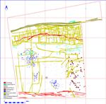
Figure 4: Classified feature plot for Site 28 showing the distribution of features on the basis of initial interpretation.
To the south of, and bounded by, the major boundary ditches, the area can be subdivided into a number of clusters of activity (Fig. 4). The palimpsest of ditched enclosures covering an area c. l00m wide from north to south, and aligned east to west, comprise part of the 'ladder settlement'. To the south of this area, on the eastern side of the field, a group of small circular and sub-rectangular ditched features belong to a distinctive class of monument not previously identified; these are associated with the ladder settlement here and in a number of other locations in the research area. Further south, beyond a large sub-rectangular enclosure, a series of very strong sub-rectangular anomalies show the same characteristics as the Anglo-Saxon Grubenhäuser, identified through geophysical survey and subsequently excavated at West Heslerton. Following the southern edge of the field a number of linear features indicate the boundary ditches of an ancient and probably prehistoric trackway. Towards the western side of the field, 65m to the south of the ladder settlement, a large 17m-diameter circular ditched feature associated with a number of other small ditched features and small anomalies may represent a cemetery; likewise two further small clusters of small anomalies may relate to other groups of inhumations. Other linear features, one of which cuts through the larger ring-ditch, are likely to represent ancient field boundaries associated with the ladder settlement. A single large and very strong circular anomaly in the centre of the southern half of the area is probably modern, and may have been a war-time searchlight placement associated with 'Heslerton Aerodrome', which went out of use in the 1950s.
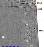
Figure 5: Detailed view of the geophysical survey results over the eastern half of the site showing the location of the three trenches 28M, AB and AC.
In order to minimise the damage to the turf crop and the compensation for loss of crop, the three areas selected for excavation were situated adjacent to the eastern boundary of the field where an existing farm track provided access (Fig. 5). Fortunately, the level of activity indicated adjacent to the eastern boundary provided suitable locations for excavations to satisfy the research objectives.
© Internet Archaeology/Author(s)
URL: http://intarch.ac.uk/journal/issue27/2/3.1.html
Last updated: Wed Nov 11 2009