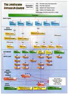
Figure 45: The Landscape Research Centre Excavation data flow diagram.
The data flow from excavation to analysis, archive and publication is illustrated in Figure 45. This reflects the basic data-gathering sequence, the recording method (whether by PDA or laptop), and the basic building blocks and linkages in the resultant digital archives. This process model forms part of a broader data management model that encapsulates all data generated and collected by the LRC, including remote sensing data, landscape information, surface and sub-surface modelling data and the results of landscape sampling programmes, the results of which are combined into Landkeeper's Dossiers, which identify and quantify the archaeological resource, its preservation and potential at a landscape scale (Powlesland et al. 2006).
Figure 45: The Landscape Research Centre Excavation data flow diagram.
The data flow model applied today is little changed from that used in the 1980s, although it has been enhanced by the incorporation of the Matrix manager and image bank, incorporating scanned and digital images. Prior to the excavations discussed above, handheld data collection in the field had been centred around home-written software written for specific handheld computers.
The introduction of the PALM handheld computers made data entry far easier, using hand-written text in GRAFFITI format, than using the tiny keyboards of earlier devices. The commercially available database, ThinkDB, imported our data structures and provided both an excellent and easy-to-use interface for data collection with sophisticated synchronisation with our Access database. No changes were required in the extant record structures, although the increased memory capacity and ease of incorporating free text, enabled far greater freedom to enter free text than had been possible in the past.
While the conventional database components are now maintained using Microsoft Access, the stratigraphic data are maintained using the LRC Matrix Manager, a dedicated software component, and the digitised drawings are also created and managed using our own GIS (G-Sys).
© Internet Archaeology/Author(s)
URL: http://intarch.ac.uk/journal/issue27/2/5.2.html
Last updated: Wed Nov 11 2009