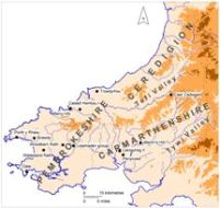
Map 1: Location map showing sites mentioned in the text. Land over 250m and 500m is shown shaded.
In 2003, the Gwynedd Archaeological Trust, with grant-aid from Cadw, produced Prehistoric Defended Enclosures: Scoping for pan-Wales Assessment (Smith 2003), which assessed current knowledge of hillforts and defended enclosures in Wales. It also indicated directions that future studies might take, suggested recording methodologies and proposed management criteria. On the basis of Smith's report, in 2004 three of the four Welsh Archaeological Trusts (Gwynedd, Glamorgan-Gwent and Dyfed) successfully applied to Cadw for grant-aid to further the study of defended enclosures in their areas. The fourth Trust, Clwyd-Powys, started their project the following year. Dyfed Archaeological Trust's project in 2004 was desk based (Murphy and Manwaring 2004) with the objectives of classifying and quantifying hillforts, defended enclosures and promontory forts in the three counties (Carmarthenshire, Ceredigion and Pembrokeshire – formerly grouped into one county called Dyfed) of southwest Wales, assessing the significance of sites, and evaluating their vulnerability. In addition, the project provided the opportunity to integrate numerous disparate sources on defended enclosures into the electronic database of the Dyfed Historic Environment Record (HER). In total approximately 250 new records were created.
A three-year programme of fieldwork followed on from the desk-based study: Ceredigion in 2005, Pembrokeshire in 2006 and Carmarthenshire in 2007 (Map 1). The other Trusts undertook similar programmes. The objectives of these surveys were to provide up-to-date data on the condition of sites, to be incorporated into regional HERs, and to make recommendations to Cadw on which additional sites should have statutory protection through scheduling. Following on from the three-year programme, a small number of defended enclosures that had been overlooked in the original county surveys were visited and assessed in 2008. Only those sites that had been previously recorded were visited: no new prospection was carried out.
Methodology and a pro-forma site recording form were agreed between the four Trusts to ensure consistency across the country. Among the categories of information recorded were: site type; form of site; condition; altitude; location; land-use; size of internal area; shape; presence/absence of houses; form of defences; type of entrance; type of annexe; threats to site; and criteria/scoring for scheduling. Because a high proportion of the defended enclosures and related sites in southwest Wales were Scheduled Ancient Monuments (the 2004 desk-based study identified 215 scheduled sites out of a possible 915 sites in total) it was decided that all non-scheduled sites should be visited but only one in ten scheduled sites. Information on the unvisited scheduled sites was gleaned from existing records, published and manuscript, and entered on pro-forma recording forms. All collected data has been entered onto the Dyfed HER.
One of the immediate problems in approaching the recording of such sites was the lack of site type definitions. Therefore the following definitions were devised and used:
In this study the site type 'enclosure' is not considered.
© Internet Archaeology/Author(s) URL: http://intarch.ac.uk/journal/issue28/1/1.html
Last updated: Mon Dec 14 2009