3. Results of the Southwest Wales Defended Enclosure Project
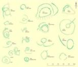
There is a wide variety in shape and size of defended enclosures in southwest Wales, as noted above. Figures 1a and 1b show a selection of sites, ranging from small univallate cropmark sites through to large earthwork hillforts. Examples of recently discovered defended enclosures are shown in Figures 2, 3, 4 and 5. Further comments are offered on these sites below.
Figures 1a and 1b: Selection of Iron Age defended settlements in southwest Wales. Numbers are those assigned on the Dyfed Regional Historic Environment Record housed with Dyfed Archaeological Trust, Llandeilo, Carmarthenshire SA19 6AF.
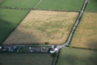
Figure 2: Cropmark enclosure at Ffynnoncyff (record no. 35715, photo ref. 89-cs-659). RCAHMW Crown Copyright.
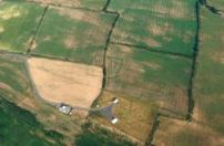
Figure 3: Cropmark enclosure at Ty-hen (record no. 2104, photo ref. 96-cs-1736). RCAHMW Crown Copyright.
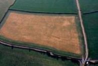
Figure 4: Cropmark enclosure at Cawrence (record no. 11267, photo ref. 96-cs-1435). RCAHMW Crown Copyright.
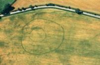
Figure 5: Cropmark enclosure at Treferedd Uchaf (record no. 8386, photo ref. AP_2005_1493). RCAHMW Crown Copyright.
3.1 Overall number of sites and distribution.
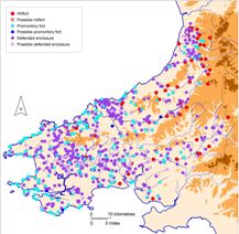
Map 2: Distribution of all sites by type.
The numbers of each site type are shown on Table 1 and their distribution on Map 2. It should be kept in mind that the division of sites into the three main categories listed in Table 1 is somewhat artificial. For instance, the same features could be shared by two sites but one could be a cropmark site situated on a hillslope and be classified as a defended enclosure, while the other might be located surrounding the summit of a hill and fall into the category of hillfort. What is immediately striking about the distribution of sites as shown on Map 2 is the lowland distribution of all sites: very few sites lie above the 250m contour and, of those that do, only three or four in the north of Ceredigion can be said to occupy a truly upland landscape. Almost no Iron Age undefended settlements are known across the whole of southwest Wales, let alone in upland areas, and consequently there is very little evidence for occupation of the uplands in this period.
Table 1: Total numbers of definite sites and possible sites and their form: earthwork, cropmark or other.
Earthwork
Cropmark
Other
TOTAL
Hillfort
58
0
0
58
Hillfort?
0
0
1
1
Promontory fort
156
2
4
162
Promontory fort?
2
0
2
4
Defended enclosure
309
164
8
481
Defended enclosure?
35
44
2
81
Total
560
210
17
787
Several clear clusters of sites are evident on Map 1, some of which probably approximate to the true prehistoric distribution, while others may be due to other factors. For instance, the large number of defended enclosures in southwest Ceredigion is the result of intensive aerial reconnaissance over the past 30 years; these are almost all cropmark defended enclosures. In the north of the county, sites are more varied in type and form, but this cluster is at least partly the result of exploration by Toby Driver (2005) of the RCAHMW in connection with his PhD research. The relative paucity of sites across the centre of Ceredigion may be the result of limited exploration, as here the Regional Historic Environment Record lists numerous place-name sites indicative of defensive settlements, such as Castell and Caer. It is possible that future research will locate earthworks or cropmarks that correspond to these place-names. The large number of relatively small sites across the fertile land of central Pembrokeshire and western Carmarthenshire is a reflection of the prehistoric distribution (although undoubtedly more sites await discovery) and, as these small sites seem to be later in the sequence, indicates a high population density in this part of southwest Wales in the later Iron Age.
As well as the paucity of defended settlements across the uplands, other areas exhibit low numbers of sites. A band running east-west across southern Pembrokeshire is notable, and very few sites are recorded in southeast Carmarthenshire. Both these areas lie in the south Wales coalfields, which are noted for their poor soils. It is unclear whether these areas were scantily settled in the Iron Age, or whether rough vegetation on the poor soils hinders detection; the former is more likely as sites of all prehistoric periods are poorly represented across the same areas.
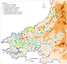
Map 3: Distribution of all sites by site type and by form.
The majority of sites survive as earthworks (560 out of a total of 787), with 210 cropmark sites identified (Table 2). All definite hillforts survive as earthworks, as do most promontory forts; this is not surprising as both these type of sites tend to be in locations not generally suitable for intensive agriculture and so have not suffered the long-term gradual degradation experienced by many defended enclosures that are concentrated on agricultural land. Even so, of the 481 recorded defended enclosures 309 survive as some form of earthwork, as opposed to 164 cropmark sites. The distribution of site type and form (Map 3) is to some degree a record of the results of aerial reconnaissance, in addition to other, less overt, data. For instance, across central Pembrokeshire and western Carmarthenshire the discoveries of cropmark defended enclosures over the past 30 years have added to the overall numbers of this type of site, which here dominate the distribution, while in northern Ceredigion discoveries of cropmark defended enclosures augment a corpus formerly dominated by hillforts and promontory forts. On the other hand, in southwest Ceredigion cropmark defended enclosures are virtually the only site type. Clearly this has repercussions for other areas: would intensive aerial survey reveal a density of cropmark defended enclosures in the Tywi valley to supplement the known earthwork sites?
Table 2: Total number of sites by condition.
Condition of site
No. of sites
A – Undamaged earthwork
17
B – Good earthwork
203
C – Slight earthwork
331
D – Cropmark
208
E – Destroyed
11
U – Unknown
17
Total
787
It is worth noting that only 11 sites are recorded as destroyed (Table 2). While most of these are relatively small, low earthwork or cropmark defended enclosures that have been built over, the number does include a few larger earthwork sites destroyed by quarrying or large-scale development, usually during the 1950s and 1960s.