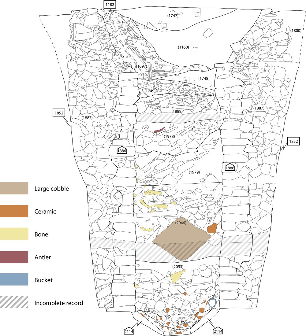
Figure 2: Complete section drawing of the well © Helen Goodchild. Used with permission. If your device allows, hover over the section to reveal context and artefact descriptions. [View static image]
Various methods were used to access natural springs at Heslington East from at least the Early Bronze Age, creating clusters of watering holes and wells along the 22m AOD contour. Some of these features might be considered wells but many were less formal, consisting of areas of cobbling or irregular cuts consolidated with driven stakes and timbers. Split timbers were used as Early Bronze Age 'well linings', but several Iron Age features were unlined. A number of late Roman wells on the site were wattle-lined or revetted with timber/cobble.
A well of significantly different character (Figure 2) was constructed on the 26.5m AOD contour, approximately 65m upslope from the spring-line. It represented a major change to the monumentalisation of this part of the hillside, seeming to mark the demise of a substantial masonry building, associated kiln and other facilities, and its replacement with a framed structure connected with the use of hearths and associated working areas. Stratigraphically, the well must have been dug in the second half of the 4th century. Ceramic assemblages associated with its backfilling, in particular the Huntcliff-type jars and signal station Type 24 jars, as well as the ratio of Crambeck grey ware to calcite-gritted ware (Bidwell and Croom 2010, 30), imply that it probably fell out of use around the end of the 4th century/beginning of the 5th century. This dating thus allows a very short period of use or a lifespan of some decades.
Figure 2: Complete section drawing of the well © Helen Goodchild. Used with permission. If your device allows, hover over the section to reveal context and artefact descriptions. [View static image]
The feature was set within a circular cut, 3.2m in diameter (1852), which extended to a depth of 4.35m, intruding into earlier ditches then into a combination of natural clay deposits to the north and free sand elsewhere. Upon excavation, an active spring was encountered c. 1m below the current ground surface. The well's main structure used facing stones of squared-off, roughly hewn, oolitic limestone blocks, probably from a nearby source such as the exposures near Malton 30km to the north-east, plus occasional sandstones (1886). These stones, curved on their outer surface, were set in carefully defined, regular courses and none had been reused (with the exception of a roof finial). Packing behind them comprised irregular and uncoursed cuboid blocks of variable size (1887). There was no evidence of any formal bonding material between the stones, but the whole was packed with mid-brown clay and a little silt, which became increasingly sandy with depth (1800). The base of the well was dish-shaped and composed of triangular limestone slabs set directly on natural clay (2114) (Figure 3). The engineering employed thus suggests an intimate understanding of the subsoil. The well's fills are described next in some detail, because only careful consideration of formation processes can elucidate the complexities here, especially in relation to the feature's demise.
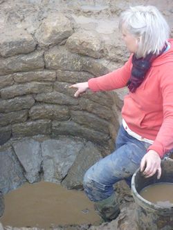
Figure 3: Base of the well under excavation
Its primary fill (2109) comprised dark grey coarse sand and some silt, 0.30m deep and containing frequent variously sized pebbles and cobbles. This deposit seems to have accumulated while the feature was in use, its limited depth perhaps implying regular cleaning. Datable material from this deposit thus probably registers only the point at the very end of the feature's use. The interface between this fill and overlying deposit (2093) was diffuse. The latter, 0.75m deep, comprised black, organic, waterlogged silt densely packed with limestone fragments up to 0.15m across, these becoming smaller and more rounded towards its base and including some cobbles. The character of this layer, notably the profusion of building material within it, implies either a deliberate backfilling process, which caused the well to go out of use, or the collapse of some of the superstructure when facing stones were robbed from the top of the structure, and the core then fell in. Either way, this must have happened immediately after the underlying layer stopped forming.
Above 2093, was a 1m deep, brownish-black organic silt containing frequent limestones, mostly between 0.10m and 0.15m across (2046). A very large, rounded cobblestone 0.75m across in the base of this fill may have been deliberately deposited at its base to mark the well's demise. Certainly, on its deposition, the well must have ceased to function. Above this lay an irregular c. 0.75m deep fill of brownish-black organic silt containing twigs and limestone blocks up to 0.20m across (1979). It showed evidence for tip lines running downslope from the north to the south, while angled stone elements imply collapse of the wall core from above after robbing of facing stones. 2046 and 1979 seem likely to have been deposited as a single event, in a short space of time.
Greyish-brown clay and a little silt, 0.45m maximum depth and containing frequent small limestone fragments (1978) covered 1979 with an undulating and irregular interface. This pebbly, clay-rich deposit, shallower than previous fills and lacking obvious tip lines, suggest formation over a more extended period of time. Although recorded as shown in Figure 2, it now seems likely that 1978 would include the stony component recorded as 1979, leaving 1979 as a stone-free deposit. An overlying fill, 0.62m deep, comprised greenish-brown clay containing silty pockets and frequent blocks and fragments of limestone (1888). Both fills imply silting in slow moving/stagnant water, something supported by the horizontal attitude of most of the larger stone inclusions, except in the limited area on its southern side.
A 0.30m deep profusion of variously sized masonry, mostly thin, flat limestones, set in brown clay extended above 1888, lensing out to the north (1749). Above this, lensing out to the south, lay a much cleaner fill of greyish-brown sand and some silt containing occasional fine pebbles and small sandstone fragments (1748), probably a water-laid accumulation levelling up the dip produced by underlying 1749. At this level the profile of a cut 1182 was recorded, but is now interpreted as part of the process of collapse. Above this was a deposit of limestone and a few sandstone blocks and tile fragments set in brown silt (1697), 1m deep in the south but tailing out to nothing before it reached the north side of the well. This is clearly a substantial collapse of the southern wall core. The three horizons thus imply two stages of well disintegration separated by a phase of puddling.
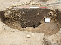
Figure 4: Photograph of east-facing section showing 1697, 1160 and 1747
A cleaner deposit of dark brown silt containing frequent small limestone fragments, moderate sand and occasional charcoal flecks (1160/1181) covered 1697. Mixed brown and black silt (1747) containing frequent charcoal flecks and fragments, moderate sand flecks and occasional fine and medium pebbles and limestone fragments then completed the backfilling sequence within the line of the well to a level of c. 26m AOD (Figure 4). Above this were deposits of dark greyish-brown silty clay containing frequent flecks of limestone and sandstone and occasional small fragments of the former plus charcoal in smears (1188), then an area of greyish-black silty sand containing burnt cobbles (1106). These last two layers were confined to the limits of the well head but had clearly been deposited long after it had long fallen out of use (they were excavated as layers and therefore are not represented on Figure 2). Stone flecking within 1188 could relate to continued dismantling of the well stone work, which would still have been visible at this point. Traces of burning in 1106 could suggest the dumping of former hearth material in a convenient hollow or activity associated with the dismantling and recycling the well's stone lining.
Roskams and Neal: Assessment report (Digital Archive)
In sum, therefore, the detailed study of deposits (see archive Assessment Report) suggests six distinct episodes in the feature's development:
Internet Archaeology is an open access journal based in the Department of Archaeology, University of York. Except where otherwise noted, content from this work may be used under the terms of the Creative Commons Attribution 3.0 (CC BY) Unported licence, which permits unrestricted use, distribution, and reproduction in any medium, provided that attribution to the author(s), the title of the work, the Internet Archaeology journal and the relevant URL/DOI are given.
Terms and Conditions | Legal Statements | Privacy Policy | Cookies Policy | Citing Internet Archaeology
Internet Archaeology content is preserved for the long term with the Archaeology Data Service. Help sustain and support open access publication by donating to our Open Access Archaeology Fund.
File last updated: Fri Jun 21 2013