Figure 5: Chart illustrating the proposed flow of knowledge exchange and production.
In light of the benefits of LIDAR technology and the potential of web-based collaborative approaches, the project aims were to bring the benefits of GIS and LIDAR processing software to a user group that may not otherwise have the expertise or resources to utilise GIS or remote-sensed data (Table 1). The non-expert in this case can be defined as a participant with an interest in and/or knowledge of archaeology or the landscape under study but little or no experience using remote-sensed data or GIS technology.
Drawing upon the ideals of citizen science, the project not only endeavoured to build a reciprocal exchange of knowledge between professionals and the public but also to empower communities to wrestle the products of GIS-based analysis from the hands of the 'expert' into a skilled and knowledgeable community. A futher aim was to allow community engagement with their collective heritage in new and innovative ways, assisting in an increased democratisation of cultural heritage studies. This means not only the possibility of contributing to the HER but also the production of 'alternative' maps to those created by the state or governing bodies, providing another view of the landscape and diffusing the didactic nature of current historical cartography and dissemination. This essentially produces non-institutional data '…reflecting a public perspective rather than an expert or institution perspective' (Caquard 2005, 349). In addition, alternative methodologies of archaeological enquiry requiring non-destructive techniques can also aid in challenging the propensity towards excavation exhibited currently by community archaeological groups, which, where appropriate expertise or guidance is lacking, is a cause for concern among local authority and commercial archaeologists. This is due to the potential not only for the irrevocable loss of archaeological sites but also data loss, as sites may not be adequately recorded (Thomas 2010, 49).
| Objective | Description |
|---|---|
| 1 | The production of a web-based mapping application, enabling interpretation of archaeological features to empower various stakeholders to engage with remote-sensed datasets and contribute to archaeology without employing intrusive and potentially destructive methodologies. |
| 2 | Explore the value of the production of alternative maps expressing multiple interpretations and the production of 'non-institutionalised' datasets. |
| 3 | Identify and utilise open-source methods of LIDAR processing and web map production ensuring no barriers to the freedom of stakeholders to engagement, and also facilitate future development at minimal cost. |
| 4 | Develop online training resources to aid non-expert users, based upon local HER data and archetypal archaeological features typically discernible from LIDAR data. |
| 5 | Assess the validity and efficacy of the interpretation of archaeological features. The results of interpretation by non-expert users will be field-tested to evaluate interpretations. Also, where possible, the validation of and 'ground truthing' of features known to Gloucestershire HER from previous investigations using data derived from the project and contributions of features or attributes to existing HER datasets. |
| 6 | Assess the potential for larger web-based collaborative projects using remote-sensed data. The project is intended as a pilot study trialled with a small number of community groups, chiefly invited members of archaeological societies and enthusiasts, and as such provides a 'proof of concept' for future projects. |
| 7 | Assessment of the efficacy of different LIDAR visualisations to inform non-expert interpretation. |
To aid in the emancipation of the user and the project itself from proprietary software constraints, Free and Open Source Software (FOSS) products were used as much as possible in application development and data processing. FOSS products represent a distinct departure from the proprietorial safeguarding procedures used by vendors in the past to levy 'hierarchical and technological constraints' on what users can do with a particular product and how distribution is controlled (Jones et al. 2012, 432). Importantly, the WebGIS application code is free to access and modify for personal use or to facilitate the development of similar projects.
The project also attempted to function as a 'proof of concept' and represents the first step in assessing the efficacy of public remote-sensed data interpretation and development of the necessary web tools. Crucially, the manner in which data are generated and the potential limitations and variation in the skillset of the users may limit effectiveness of the data. Consequently, a balance between openness and quality needed to be established and the knowledge production mediated through collaboration with the Gloucestershire County Council Archaeology Service on the development of interpretational guides and evaluation of non-expert transcription via field assessment. In addition, qualitative feedback on the value of the feature regarding contribution to landscape character identified was given during transcription, providing data on the public perception of the relative value of heritage assets within the study area to obtain a more representative assignment of priority at local government level.
The effectiveness of LIDAR processing and visualisation methods has been explored in recent academic publications (Challis et al. 2011: 288; Bennett et al. 2012, 47). However, issues relating to the effectiveness of the techniques of LIDAR visualisation for interpretation by a non-expert audience have not been explored. The project allowed users to enter source information for the identified features, thus enabling assessment of the efficacy of the various visualisation methods for feature detection.
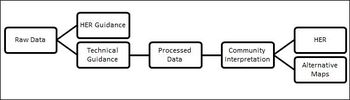
Figure 5 provides an overview of the proposed exchange processes applied to achieve stated project objectives.
Figure 5: Chart illustrating the proposed flow of knowledge exchange and production.
Internet Archaeology is an open access journal based in the Department of Archaeology, University of York. Except where otherwise noted, content from this work may be used under the terms of the Creative Commons Attribution 3.0 (CC BY) Unported licence, which permits unrestricted use, distribution, and reproduction in any medium, provided that attribution to the author(s), the title of the work, the Internet Archaeology journal and the relevant URL/DOI are given.
Terms and Conditions | Legal Statements | Privacy Policy | Cookies Policy | Citing Internet Archaeology
Internet Archaeology content is preserved for the long term with the Archaeology Data Service. Help sustain and support open access publication by donating to our Open Access Archaeology Fund.
File last updated: Wed Oct 23 2013