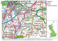
Figure 3: Map illustrating the extent of the project study area.
The area selected for the project was a 100km swathe of the Cotswold Escarpment, centred upon the village of Cranham (NGR: SO896129) between Leckhampton hillfort in the north, Stroud in the south, Haresfield Beacon in the west and Brimpsfield in the east (Figure 3).
Figure 3: Map illustrating the extent of the project study area.
The dominant solid geology of the project area is oolitic limestone of the Greater and Inferior Oolite Group, with smaller pockets of mudstone bedrock along its western periphery. Drift geology consists of small pockets of alluvium and Cheltenham sands and gravel (British Geological Survey 2012). The project area straddles the interface of two principal geographical zones; the Severn Valley and the Cotswolds Hills. The Severn Valley is a low-lying area with undulating clay punctured by gravel terraces and islands highly suitable for settlement. To the east, the Cotswolds Hills are limestone uplands with a maximum height of 310m above sea level, descending gradually eastwards (Darvill 2011, 30-1).
Internet Archaeology is an open access journal based in the Department of Archaeology, University of York. Except where otherwise noted, content from this work may be used under the terms of the Creative Commons Attribution 3.0 (CC BY) Unported licence, which permits unrestricted use, distribution, and reproduction in any medium, provided that attribution to the author(s), the title of the work, the Internet Archaeology journal and the relevant URL/DOI are given.
Terms and Conditions | Legal Statements | Privacy Policy | Cookies Policy | Citing Internet Archaeology
Internet Archaeology content is preserved for the long term with the Archaeology Data Service. Help sustain and support open access publication by donating to our Open Access Archaeology Fund.
File last updated: Wed Oct 23 2013