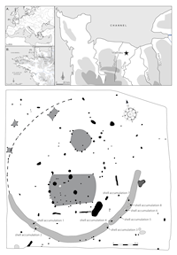
The Clos des Châtaigniers was excavated in 2010 by the French National Institute of Preventive Archaeological Research (INRAP), under the direction of David Giazzon (Giazzon 2013). This domestic settlement is located approximately 10km from the seashore, close to the River Dan, a tributary of the Orne. The archaeologists discovered a vast semi-circular structure, both pottery and radiocarbon dating assigning it to the Late Bronze Age (Cal BC 1190-980, Cal BC 1000-840, Cal BC 1050-900, Cal BC 1020-900 and Cal BC 970-820). This enclosure consists of two joined ditches, with a V-shaped profile, reaching 1.6m to 2m in depth. This structure is open on its northern side and is associated with numerous structures, mostly post-holes, but also some pits and a large combustion structure. The archaeological material is not very abundant. A small amount of slag and some fragments of crucible seem to indicate an activity linked with metallurgy. This hypothesis is reinforced by the discovery of ceramic moulds in the ditch of the enclosure and also in some pits. Even fragmented, these remains indicate the making of swords, spearheads, chapes and possibly axes. Eight shell accumulations have been identified in the ditch of the enclosure (Figure 1).