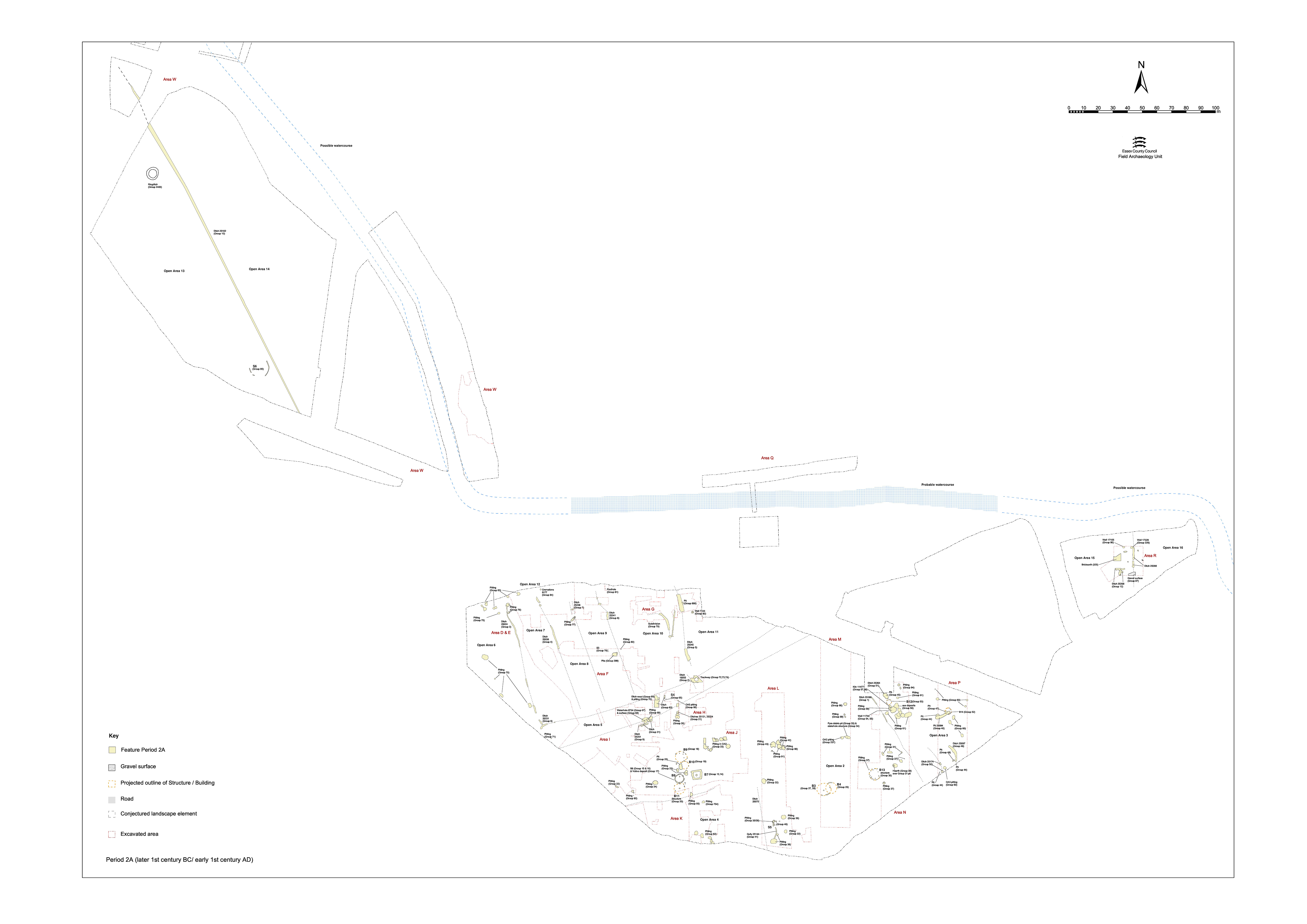
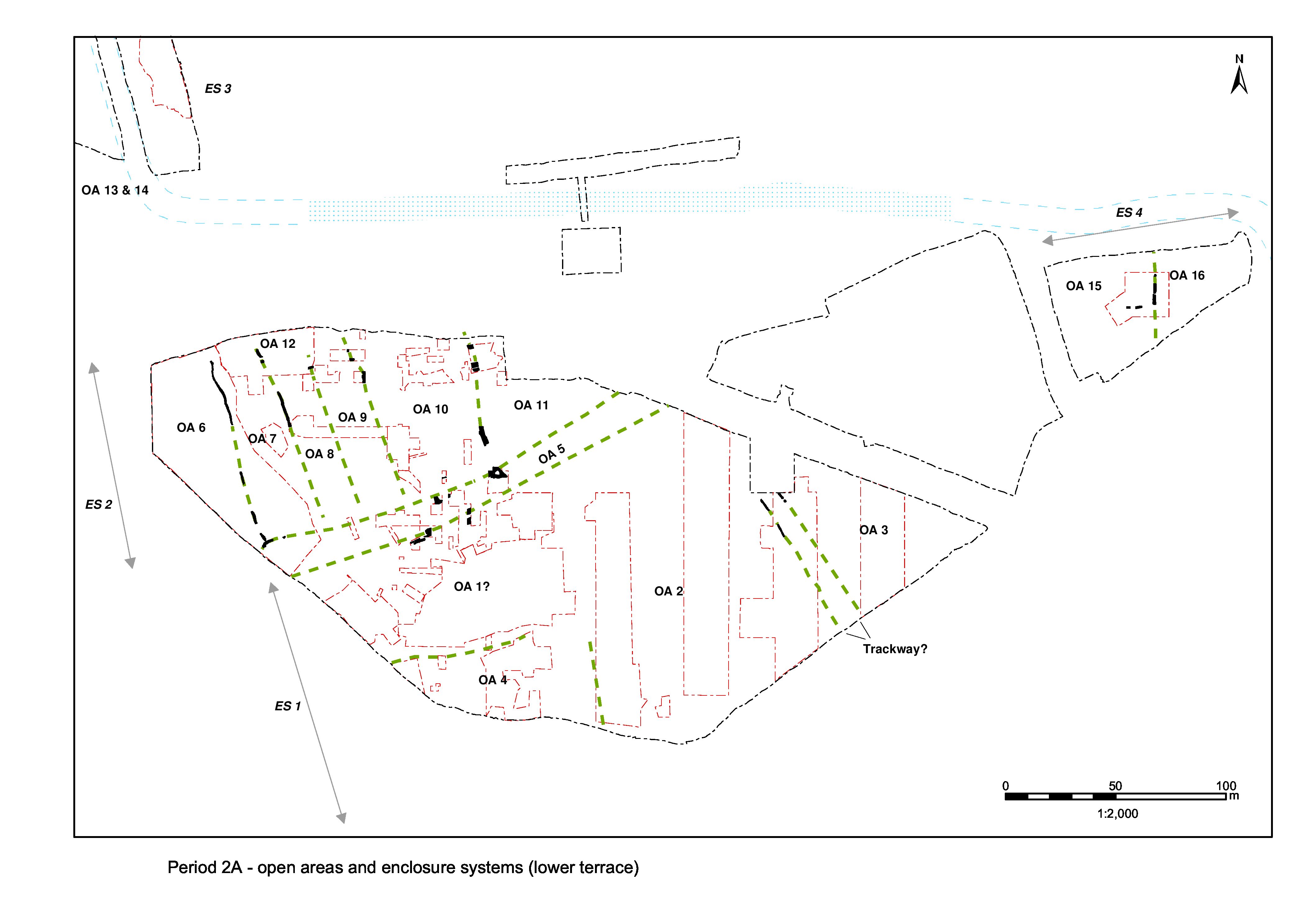
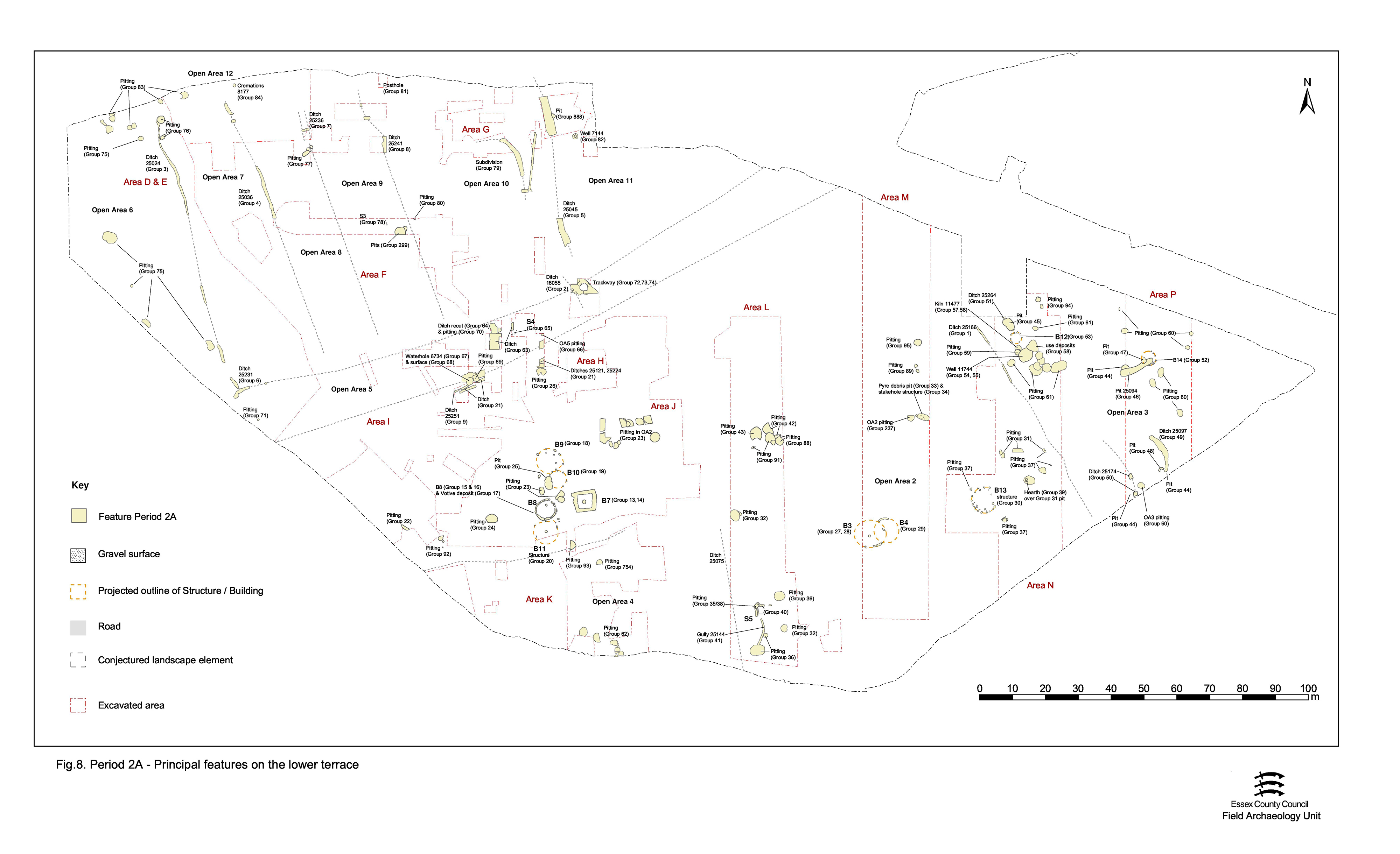
A series of rectilinear land units, possibly fields, are laid out across the northern part of the lower gravel terrace. Defined by generally slight parallel ditches, a total of six enclosures are discerned (Figure 7). These are termed Open Areas 6 to 11. Though of varying widths, all are aligned NNW-SSE. The southern limit of this enclosure system is demarcated by what is possibly a ditched trackway (OA5), while the northern limit seems more open, where its defining ditches simply terminate - perhaps at the edge of lower and wetter ground alongside the watercourse that runs just below the upper terrace step. The intervening marginal land does not appear to be subdivided (though admittedly little of this vicinity was stripped and investigated) and is regarded as a distinct land unit - Open Area 12.
Only the component parts of the infrastructure of the enclosure system are described here, from west to east. The Period 2A features occupying the interiors of the seven enclosures (i.e. OAs 6-12) are described in Lower terrace (north).
Ditch 25024 (Excavated segs 9094, 9099, 9408, 9409, 9410, 9486, 9501, 9514, 9797, 9798, 9966, 9967, 9969, 9970) is a relatively slight, 0.50-1.05m wide and c. 0.12-0.23m deep, feature running roughly NNW-SSE and forms the boundary between OAs 6 and 7. The northern part of the ditch follows an irregular course and may even actively avoid pit 9194 (Group 76). Substantial portions of it are either removed or masked by later features and deposits, but it can be traced for 76m from a bulbous northern terminal (seg. 9094) to a likely terminal (immediately south of seg. 9514), which is later truncated by a large pit (9540 Period 2B). A shorter length of ditch 9798 probably constitutes a resumed southward continuation of this same boundary. At its southern end, 25024 runs up to ditch 25231 (Group 6) - the northern boundary of suggested trackway OA5.
Ditch 25036 (segs 8096, 8147, 8205), broadly parallel with and some 25m to the east of 25024, constitutes the boundary between OAs 7 and 8. It too is slight and shallow (0.75-1.2m wide and up to 0.4m deep) and irregular in plan, particularly at its north end.
Three successive ditches 25236 (seg. 8212), 25237 (seg. 8210) and 25238 (seg. 8208), each of similar width, depth and alignment, describe a NNW-SSE aligned boundary that moves slightly westward with each re-cutting episode (25236 defines the earliest ditch, 25237 and then 25238 are the successive re-cuts). A 14m length of the ditches was exposed but no terminals located. While it is likely that this boundary extends northward beyond the limit of excavation, it cannot continue far to the south and is likely to have stopped short of the pits clustered at the terminal of the Period 2B enclosure ditch 25039. The scale of this feature suggests it is a significant landscape boundary and it is interpreted as dividing OAs 8 and 9.
Ditch 25241 (segs 10229, 10232) marks the boundary between OAs 9 and 10. This feature is c. 2-2.5m wide but only 0.20m of its depth survives later truncation by overlying Road 1 (Period 2B) - indeed the road may be construed to be deliberately laid along this earlier boundary.
Further south of ditch 25241, what was recorded in the field as pit 10552 (see Open Area 9), which almost certainly also underlies the earliest Road 1 surface, could in fact be a continuation of the same feature - perhaps constituting a terminal at a point of access between OAs 9 and 10. However, only a small portion of 10552 was investigated within the Excavation Area F 'south trench', so this must remain just a possibility.
Ditch 25045 (segs 7322, 7550, 7630) can be intermittently traced on a NNW-SSE alignment for a distance of 49m. It is speculated, but not demonstrated, to extend southwards under unexcavated Road 5 deposits. The inception of Road 5 is elsewhere dated to Period 2B. The ditch is almost 3m wide and up to 0.8m deep at its north end, narrowing to 2m at the south but also deepening (1m). It marks the boundary between OAs 10 and 11.
A more complex sequence is evident at the south end of the boundary between OAs 10 and 11. Ditch 16055 (marking the north side of Open Area 5, is truncated by ditch 16053 (Group 2). This relatively slight ditch therefore straddles both OA5 and OA10 interiors, though is not traceable for any distance to the north or south. It is possible that it is associated with a suggested point of access from OA5 into OA10 as denoted by Trackway 1.
Internet Archaeology is an open access journal based in the Department of Archaeology, University of York. Except where otherwise noted, content from this work may be used under the terms of the Creative Commons Attribution 3.0 (CC BY) Unported licence, which permits unrestricted use, distribution, and reproduction in any medium, provided that attribution to the author(s), the title of the work, the Internet Archaeology journal and the relevant URL/DOI are given.
Terms and Conditions | Legal Statements | Privacy Policy | Cookies Policy | Citing Internet Archaeology
Internet Archaeology content is preserved for the long term with the Archaeology Data Service. Help sustain and support open access publication by donating to our Open Access Archaeology Fund.