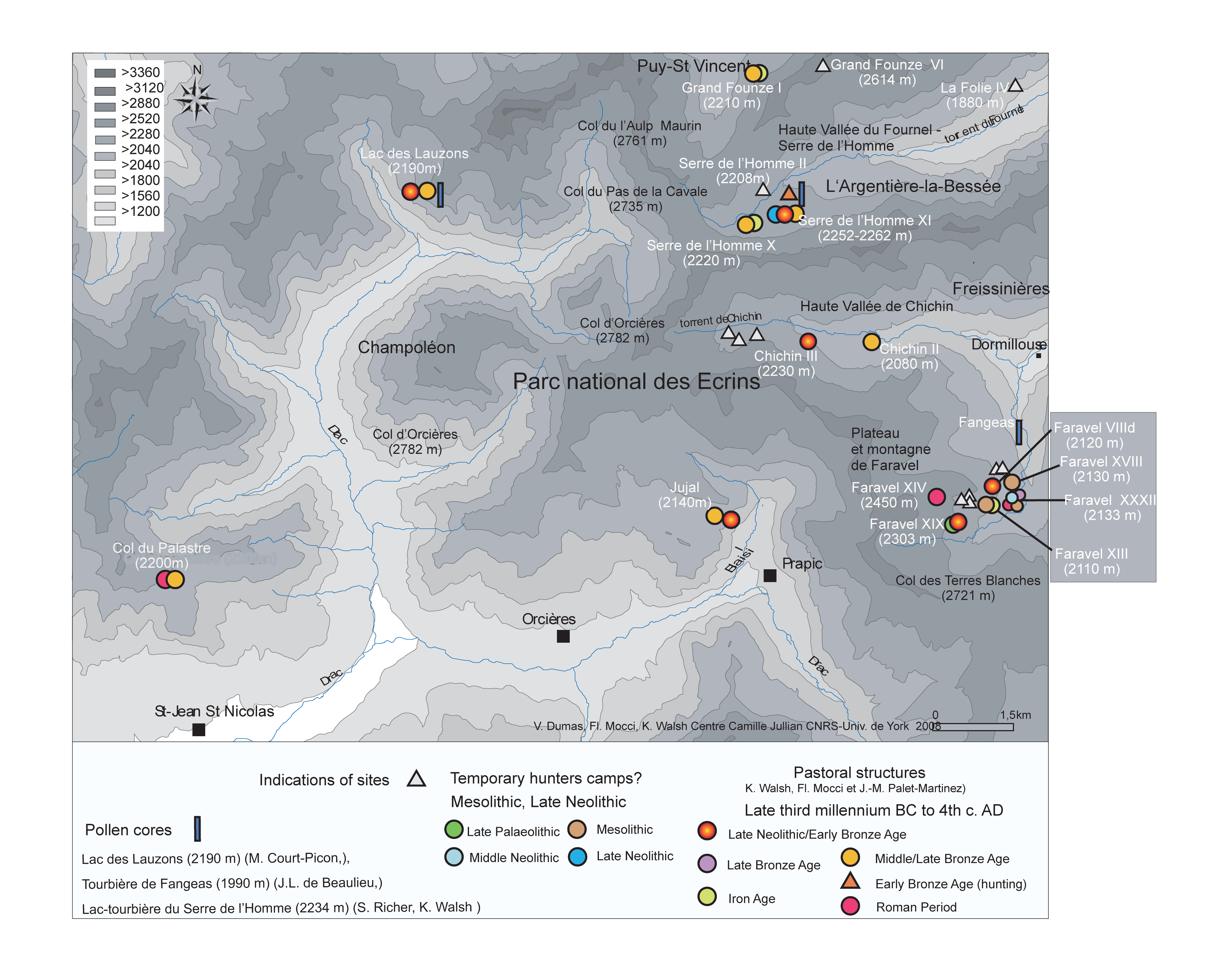
There are very few areas in the Alpine arc possessing such a rich archaeological record that suggests such persistence in human activity (Walsh et al. 2014; Walsh and Mocci 2011; Mocci et al. 2010). This section presents an overview of the principal phases of activity across the plateau (based on archaeological and palaeoecological evidence) and at the Faravel rock shelter. This section can be read in conjunction with the Faro model, which enables the reader to view the landscape context for each site and retrieve basic information for those sites (Figure 9; also see map with site locations). This background to the changing nature of human activity and environment is important for the subsequent contextualisation and interpretation of the rock art.


Sites mentioned in the text.
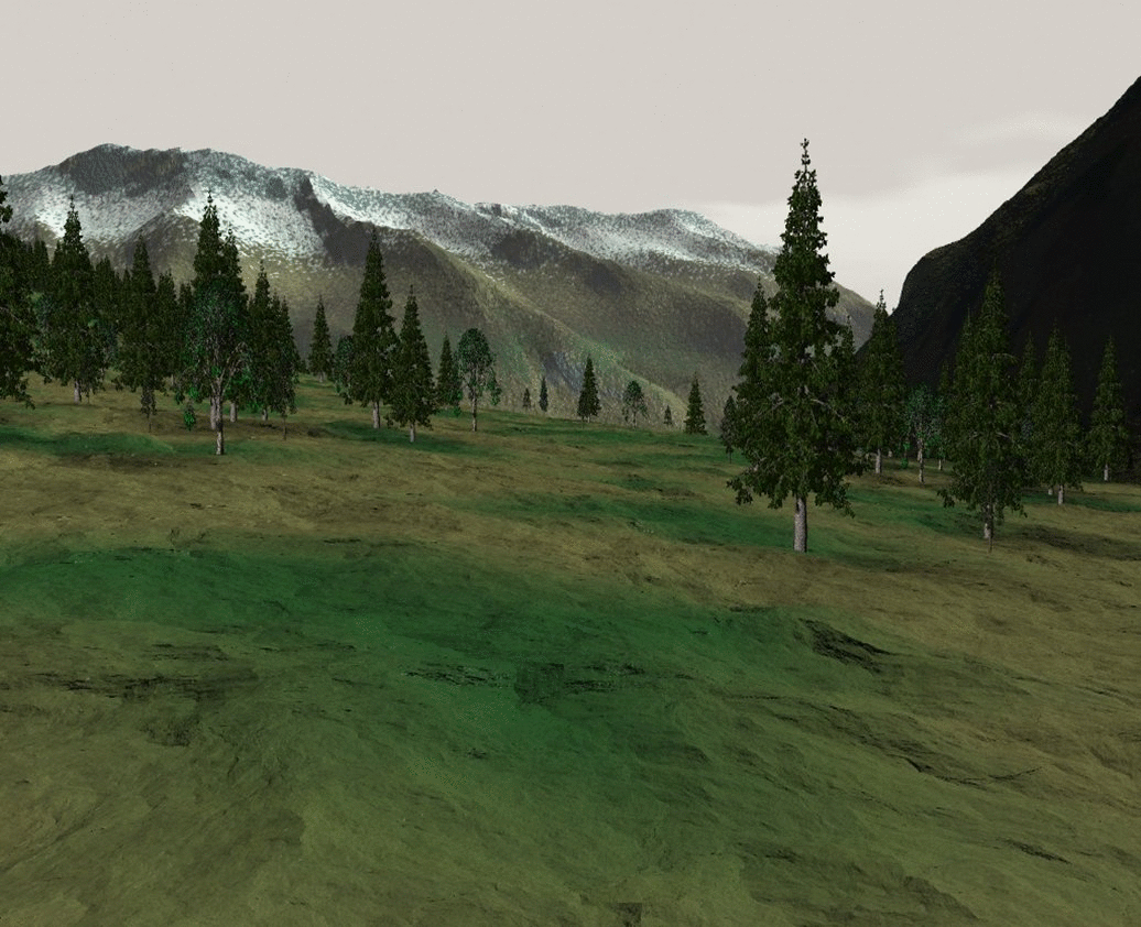
By the eighth millennium BC (the Mesolithic, Sauveterrian phase), a forest comprising Pinus and some Betula would have dominated the area. Recent studies within the southern French Alps demonstrate that during this period there was mixed, open forest as high as 2,400m (Ali et al. 2005; Talon 2010). There is little doubt that the Mesolithic forest (the timberline) was as high as 2,200m; possibly even above 2,300m in some areas. Mesolithic hunting took place across the wider plateau, with flint scatters comprising microliths found in two substantial spreads across this area (Faravel - XIII, XVIII, XXV) - 440 pieces from Faravel XIII, and 505 from Faravel XVIII. Moreover, Mesolithic flint tools (debitage and microlith armatures) represent the first phase of activity at the Faravel rock shelter. These sites are the highest known Mesolithic 'camps' in France, and some of the highest across the Alps. When we consider the location of these with regards to the upper limits of the forest, the setting of these camps across the plateau and at the Faravel rock shelter makes perfect sense (Figure 10). During the Mesolithic, this altitude (c.2,150m) would have been the edge of the forest, or relatively open forest - an ideal location to spot and kill game emerging from the trees and approaching the streams that traverse the plateau.
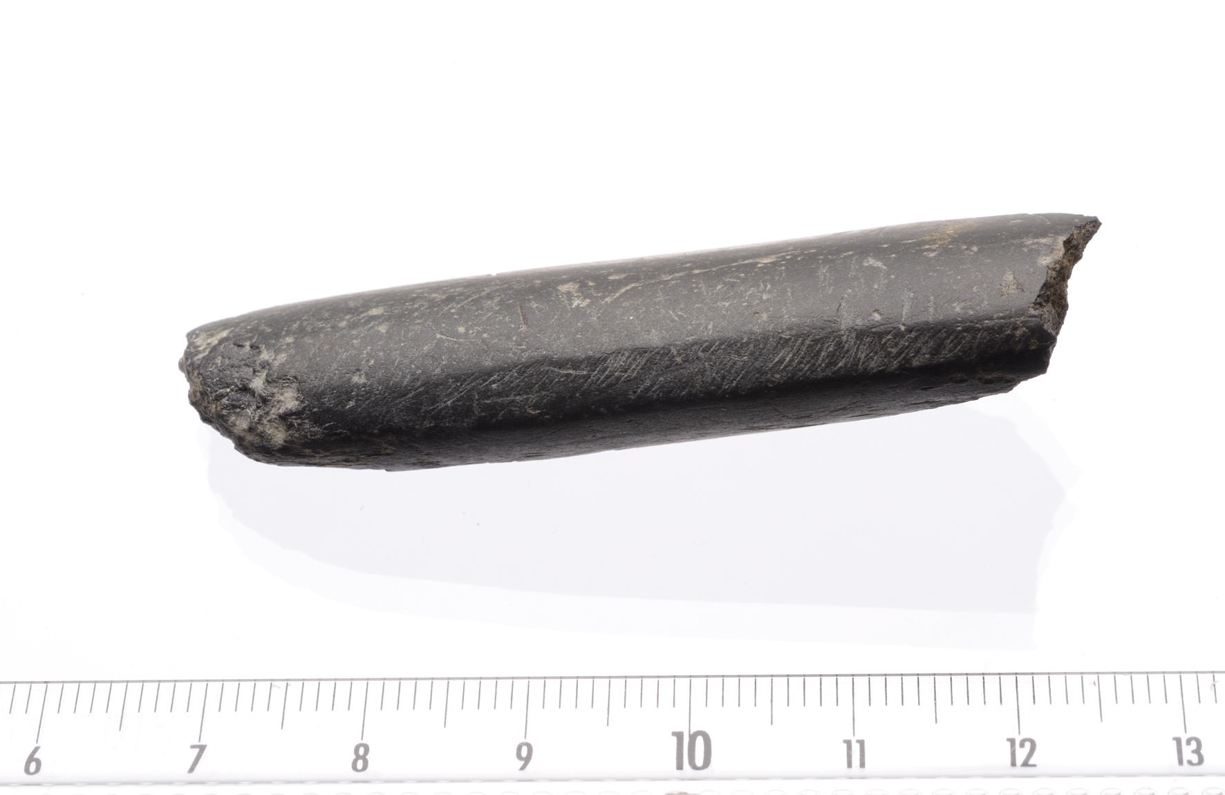
From the Early Neolithic (5500-4000 BC), palynological evidence suggests agro-pastoral activity at lower altitudes (the valley bottoms). Human activity is also suggested at high altitude in some valleys (Walsh et al. 2014), with small clearings developing in the fir forests. At Fangeas (1,990m, just below the Faravel Plateau), the Early Neolithic saw a forested landscape dominated by Pinus cembra (Arolla pine), with little evidence for human impact on the vegetation. For the Middle Neolithic (4000-3500 BC) and Late Neolithic (3500-2800 BC), there is evidence for the development of arable and pastoral agriculture across the low to mid-altitude areas (between 1,000m and c.1,800m). The archaeological evidence at high altitude from the Faravel plateau, as well from the rock shelter, comprises Middle to Late Neolithic blades and debitage, and one layer in the shelter radiocarbon-dated to 3029–2904 BC. Adjacent to the rock shelter, the sites of Faravel XXXIV, XXXVI and XLIII all possess blades, and a core at Faravel XLIII. One enigmatic find is a Late Neolithic arrowhead (Faravel XXIII) found above the plateau at 2,500m. A small polished stone axe (Faravel XLVII) was also found just above the rock shelter (Figure 11). Overall, there are ten Neolithic scatters or find spots within 300m of the rock shelter. Finally, despite palaeoecological evidence demonstrating agricultural activity towards the valley bottoms, the evidence from high-altitude pollen cores and the archaeological material from Faravel strongly suggest the continuation of high-altitude hunting, possibly alongside pastoralism. Remembering the nature of contemporary sites across the plateau, and inferences drawn from the palaeoecological data, it is possible that Neolithic hunters used the rock shelter and the plateau.
For much of the Bronze Age, Pinus cembra and Larix (Larch) dominated the high-altitude landscape. Charcoal evidence from the Faravel plateau suggests a relatively low tree density; this area would have been characterised by open woodland (Walsh et al. 2014). This environmental context is important, as it allows us to suggest that the stone structures (animal enclosures, or possibly cheese-making structures) around Faravel built during this period were situated at the forest edge, or within forest openings, possibly created by deliberate burning of the vegetation. One such structure is the site of Faravel XIX, at 2,310m; this has been dated to 2150-1920 cal BC. Interestingly, an identical radiocarbon date of 2150-1920 cal BC was obtained from another enclosure, Faravel VIIId, some 110m below Faravel XIX, at an altitude of 2,200m. It is possible that these contemporary sites, at different altitudes, represent the use of different pastures at various points in the summer. The Abri Faravel would also have been situated at the edge of, or within, open forest during the Bronze Age. One significant layer comprising charcoal has been dated to 1949–1751 cal BC. This period of activity is broadly contemporary with the appearance of the stone-built structures across the plateau and the wider area of the southern Ecrins. In many ways, the establishment of these pastoral structures can be seen as an expansion of landscape management practices related to the late development of the secondary products revolution (Greenfield 2010; Sherratt 1983) in the Alps and the exploitation of new high-altitude pastures (Walsh and Mocci 2011; Walsh and Mocci 2015).
During the Iron Age and Roman period, there were no major changes in the extent and composition of the high-altitude forest. While valley bottom clearance was quite significant, with an increase in cereal production, the high-altitude zones saw the continuation of pastoral activity, with some expansion of the pastoral zones that had been established during the Bronze Age (Walsh et al. 2014). The one archaeological site (other than an occupation phase at the rock shelter) dated to the Iron Age period is Faravel XIIIb (2,150m). This site comprises postholes dated to the early 8th century BC.
At the rock shelter, Iron Age activity is inferred from archaeological features and material dated to c.206–43 cal BC and 191–38 cal BC. As it stands, these dates are two of the most important on the site, as they date a phase that includes many sherds of hand-thrown pottery. One hundred and ten sherds, belonging to a minimum number of five vessels, have been discovered. Although this is a small assemblage when compared to low-altitude sites, these sherds constitute an extremely rare example of high-altitude pre/proto-historic pottery from the French Alps.
During the Gallo-Roman period (late 1st century BC–late 5th century AD), the data from the majority of the high-altitude pollen sites suggest little change in the intensity of human activity, or even a possible decline. As with the Iron Age, there are in fact very few archaeological sites dated to this period. The site of Faravel XIV (at 2,450m) is a superficial stone-built circular structure, which may well have been a small shelter. There is also a late 'Gallo-Roman' phase at the rock shelter. Here, the identification of this phase is based on two radiocarbon dates (315 AD–420 cal AD and 314 AD–416 cal AD) provided by charcoal from the same layer but some two metres apart. This period saw the arrangement of small boulders into a semi-circle, and the creation of a sheltered space that exploited the rock overhang, which may well have supported a pole (or poles) that in turn were draped with a protective covering. The presence of the supporting pole is implied by the discovery of substantial carbonised pieces of Arolla Pine within a posthole. Also present was a stone slab that would have secured the foot of the pole. The charcoal from this posthole was dated to 243–cal 393 AD.
These different phases of activity are each interesting in their own right, but also reiterate the importance of this rock shelter, which saw several phases of re-use: a persistent place, or node within this landscape, rendered all the more enigmatic because of the presence of the paintings.