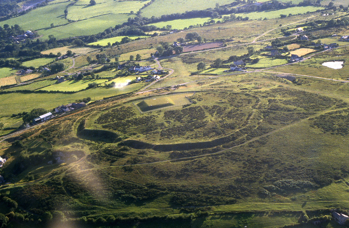
Moel y Gaer is a well-preserved contour-fort in the north-east corner of Wales (SJ211690), perched on the southern end of Halkyn Mountain, overlooking the Dee Estuary, 300m below. Numerous other hillforts fall within its wide panorama, some of them arguably more impressive for their earthworks and/or strength of topographical situation, though none in the region has been investigated as systematically and extensively as this Moel y Gaer.
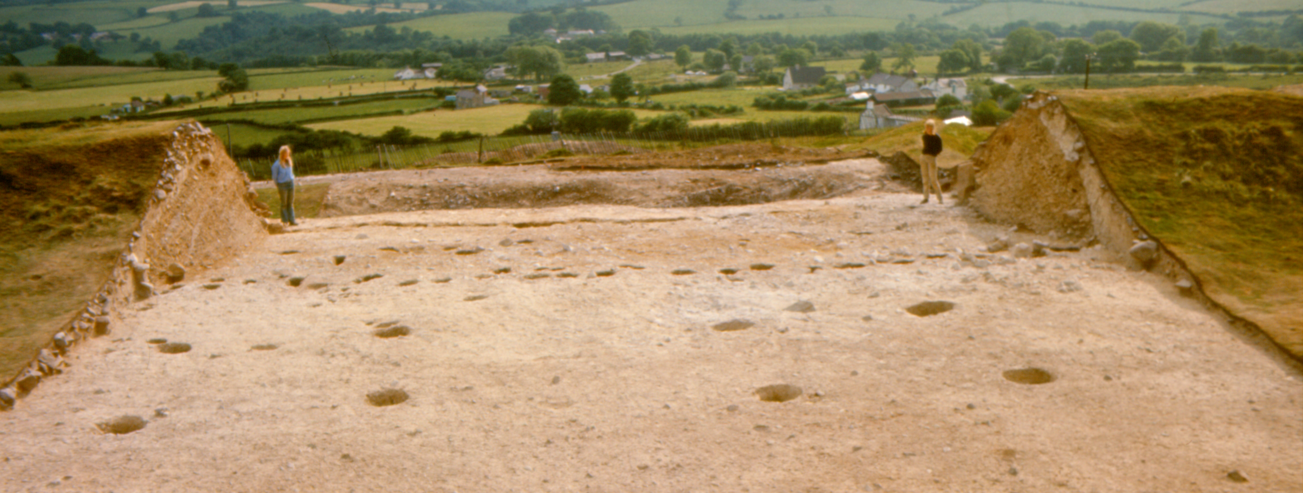
At first sight, the enclosing earthworks, or 'defences', appear simple, but this is deceptive. Only the inner bank encompasses the hilltop fully (Figure A), its c.610m course pierced by two entrances, just one of which, at the east, is convincingly ancient, being inturned and evidently equipped with guard-chambers (Forde-Johnston 1976, fig. 128d; Guilbert 1979b, 519). At its external foot, this sizeable bank is accompanied by an incomplete circuit of ditch, and, at a little distance beyond that, an intermittent second bank is generally smaller and less obvious, today being mostly shrouded in gorse. The outer bank attains a useful height only in two short stretches at the east, where it too is paired with an external ditch (foreground of Figure A). Within this enceinte, one notable feature is a mound, standing on the highest part of the hill and usually regarded as a barrow. Otherwise, much of the enclosed 2.47ha is of gentle relief, and, luckily, it has never been seriously eroded, giving great archaeological potential, especially for identifying the former positions of timber buildings and, hence, elucidating successive settlement-plans.

In the 1970s, excavation of c.0.62ha included an expanse of the hillfort interior together with two lengths of the earthworks, all in the south-west sector, where a storage reservoir was to be constructed (Figures A, B and E). This revealed a long prehistoric sequence, starting with shadowy indications of Neolithic activity, coming mainly from flintwork but speculated to have involved at least one building (Britnell 1991, 55, fig. 36). Remnants of a second barrow, probably of the Early Bronze Age (though misunderstood initially — Guilbert 1976a, 311-12, pl. VI), are chiefly of interest here because it had been levelled by the occupants of the hillfort. Of greatest significance is sound evidence for three distinct phases of enclosed settlement during the final millennium BC, essentially separable through their structural identities, coupled with helpful vertical and horizontal stratigraphical relationships, and backed by 22 radiocarbon dates measured from stratified charcoal (Guilbert 1974; 1975c; 1976b — albeit most of these dates must now be adjudged less than ideal individually).
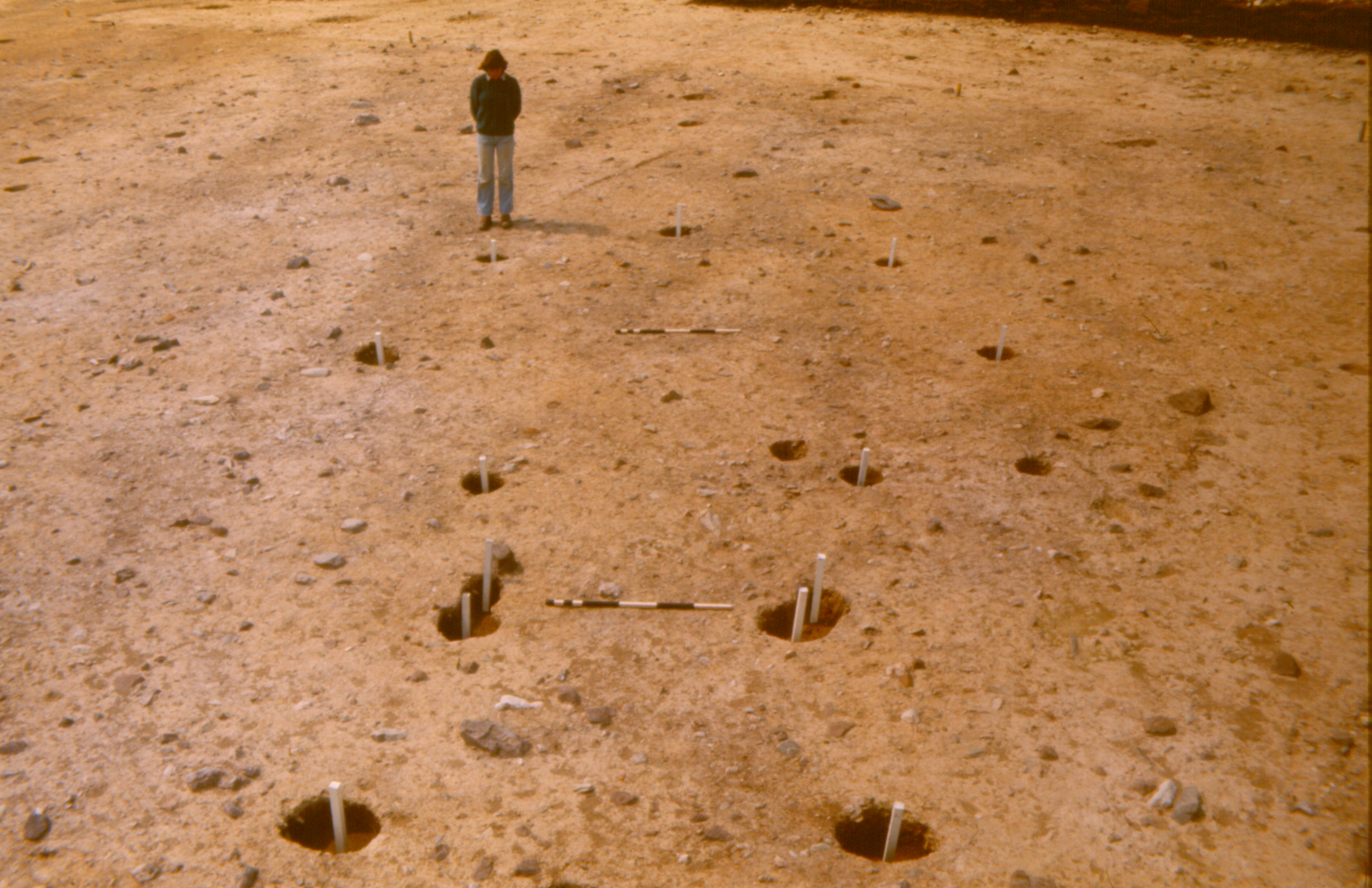
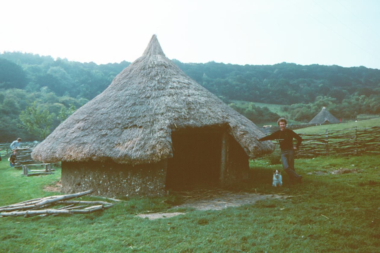
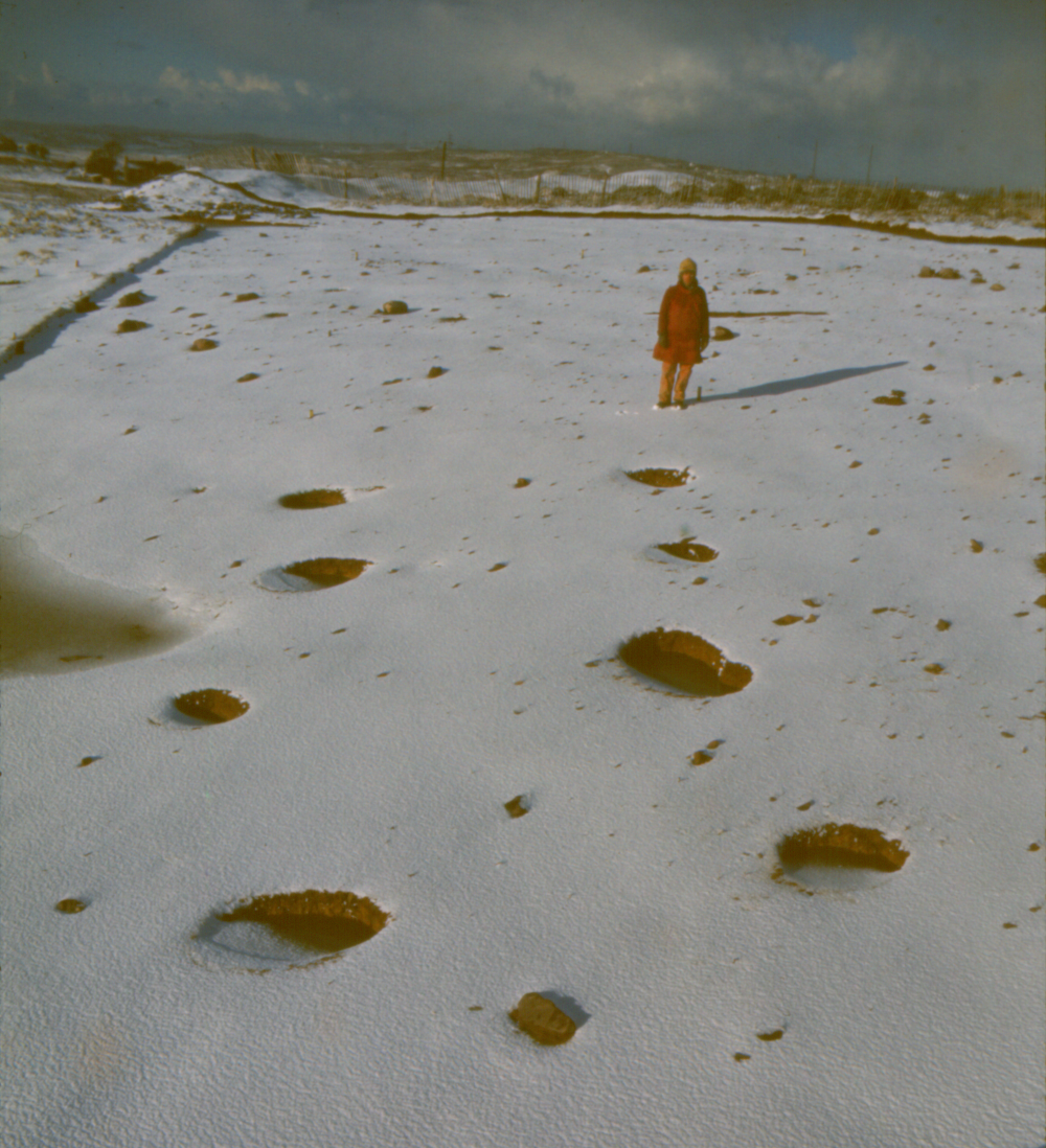
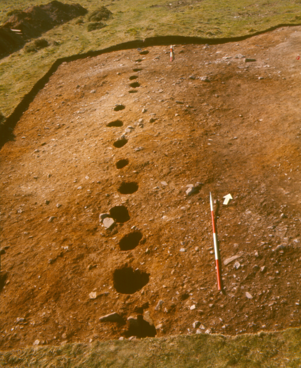
Although not closely datable, the first phase could have begun in the period of transition from Late Bronze Age to Early Iron Age (Figure B). Above all, it was characterised by roundhouses of double-ring construction, in which a ring of postholes held internal roof-supporting timbers, generally set out symmetrically, and an outer wall was fixed less deeply in the ground (Guilbert 1976a, 306-9, figs 3-4, pl. III; 1975b, fig. 5; 1981c; 1982). Twenty-six such roundhouses were uncovered sufficiently for floor-diameter to be determined, varying between c.6.5-11.5m, which translates into areas of c.33-104m². Most were entered from the east to south-east, in some cases through a simple doorway in the wall, in others via a squarish, projecting porch (Figure C). The presence of a central hearth in just eleven of these post-ring roundhouses implies that not all fulfilled the same range of functions, even though structurally alike (Guilbert 1981a, 106). Since several of them overlapped, it appears that the first settlement was somewhat protracted, perhaps expanding, perhaps contracting, or maybe migrating a short distance over time. It is also uncertain at what stage in its development an enclosing palisade was erected, freestanding and founded in a rock-cut slot (Figure D). Much like the later earthworks, this palisade probably came close to contouring around the hilltop, describing a perimeter of about 730m length (as intimated by supplementary excavations). However, not all of this settlement need have been as packed with roundhouses as the excavated portion, which amounts to roughly 13% of an estimated total for Phase 1 exceeding 4ha. There is no way of knowing whether a recorded 11m gap in the slot, flanked by postholes, was the only formal entrance into the enclosure. Anyway, the width of this opening may seem inappropriate to a purely aggressive, or even largely defensive, purpose on the part of the palisade-builders, regardless of the prominent siting (arguably as much for effect as for security, still less any realistic expectation of dominating all round), and despite the provision of a cache of pebbles (presumed weapons) in a pit at the heart of a post-ring roundhouse juxtaposed with the 11m entrance (Guilbert 1977a, 47-8, fig. 6).
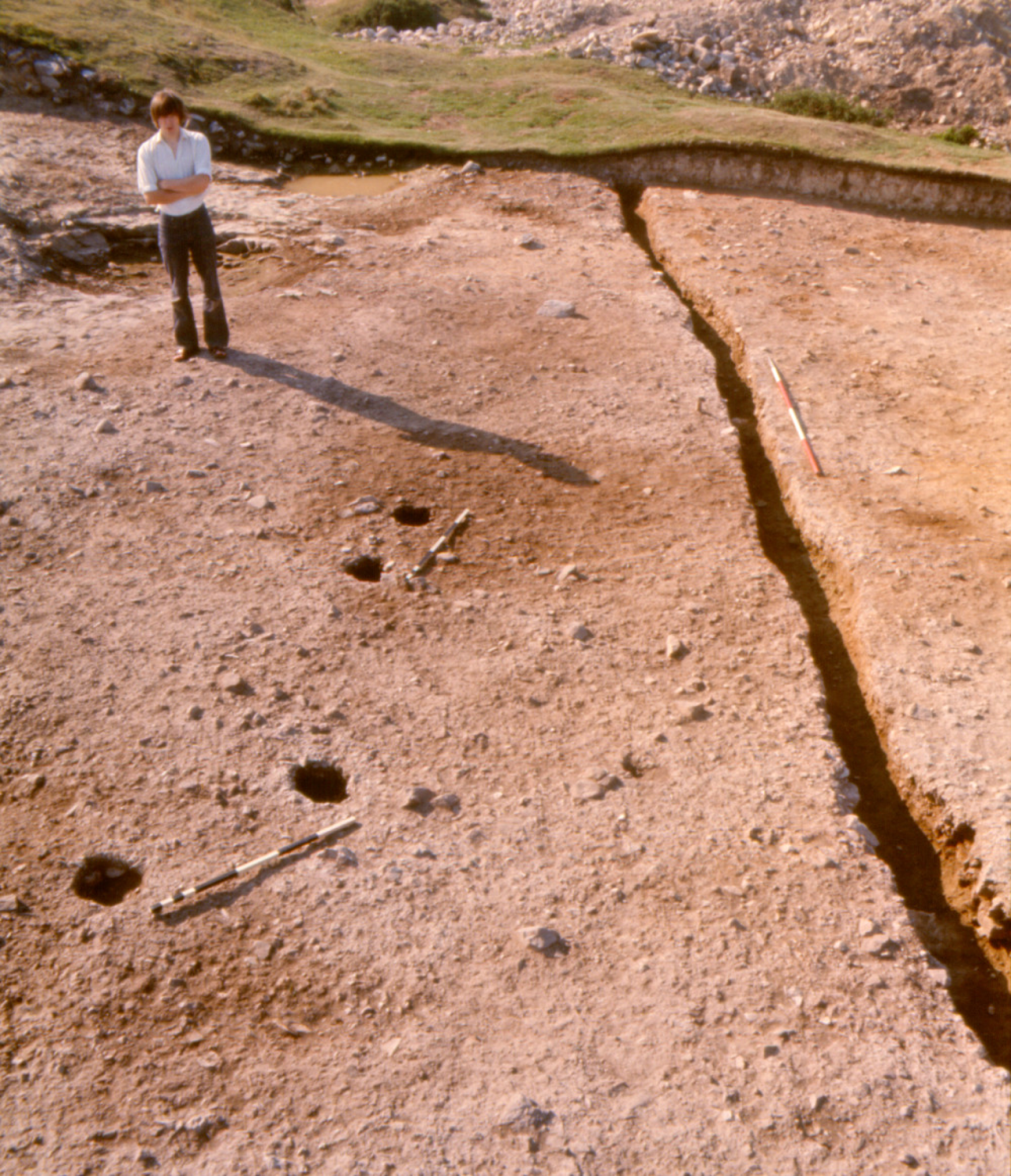
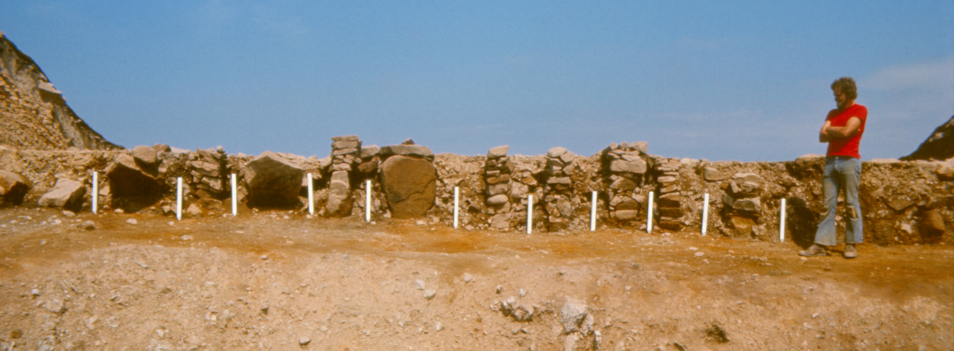
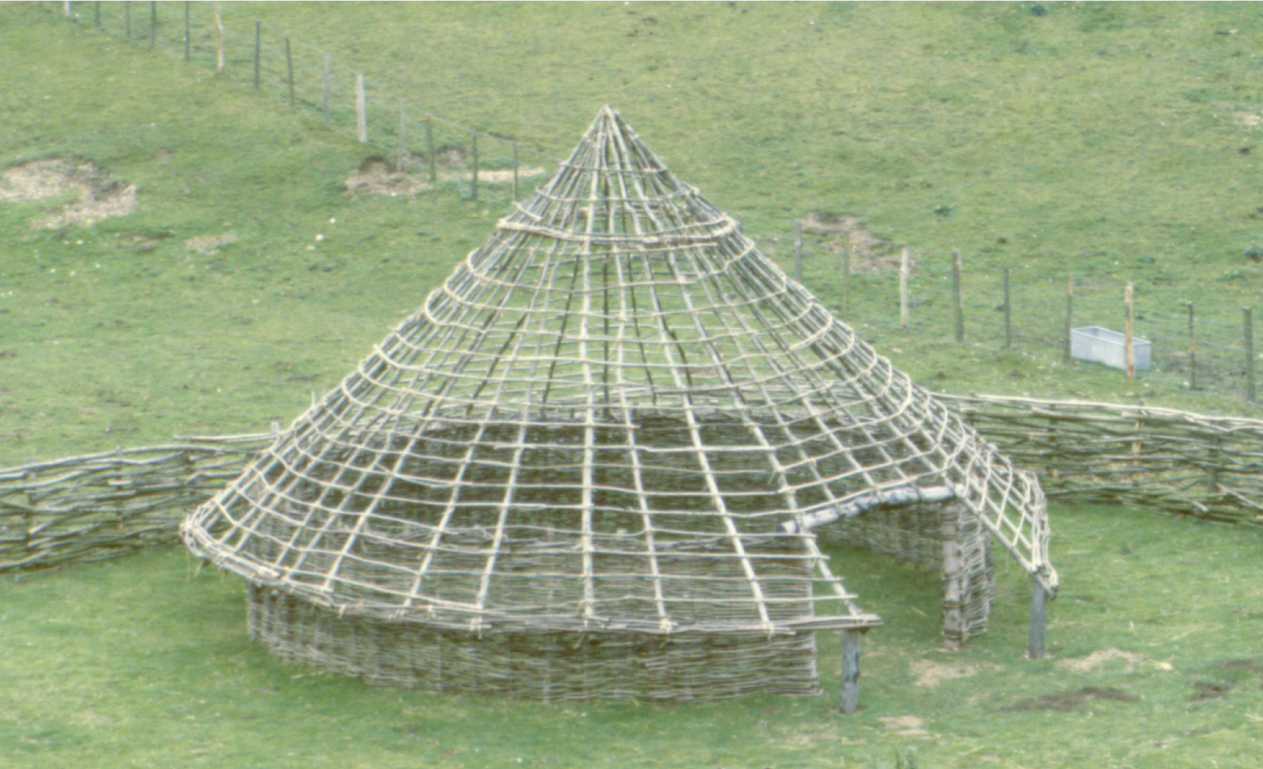
Possibly after a lengthy break in occupation, possibly not, the second phase of settlement may well have been planted upon the hill as a whole, in marked contrast to Phase 1. It was at this juncture that the inner bank was first built, an elaborate structure up to 6m wide and nearly 2m high where excavated ('Rampart A' in Figure E; Guilbert 1975a, 110-12, fig. 1). Its rear sloped down to the interior, while the vertical external face was showy, revetted in stonework alternating with posts (Figure F; cf. Guilbert 1975a, pl. XIIIa; Stanford 1980, pl. 15), which were evidently tied into a wooden framework embedded in the bank. Furthermore, the core of the bank was divided transversely, forming cells up to 2m in width, a method of construction perhaps intended to localise damage, so simplifying the task of repair (Guilbert 1975a, pl. XIIIb; cf. Collis 2001, fig. 10.11). Inside this enclosure, the 17.5% excavated sample encountered circular and rectangular structures set out in zones (Guilbert 1975b, 205-6), assumed to be elements of a tidy overall layout, lending itself to reconstruction drawings (the ground-level view demanding less conjecture than the bird's eye, as respectively reproduced in Burnham 1995, 51, and Brown 2009, fig. 96, though neither names Moel y Gaer as the subject). These Phase 2 roundhouses, c.5.7-8.1m in diameter, or c.25-52m² in floor-area, were of single-ring form, lacking internal roof-support and with wall fabricated about thin, pointed stakes driven into the ground; each had a doorway framed by upright posts at the east, some with a short porch (Guilbert 1976a, 309-10, fig. 5; 1977a, 42, fig. 3). None of the twelve excavated stake-wall roundhouses produced evidence for a hearth, and their use can only be surmised — even interpretation as roofed buildings remains uncertain, notwithstanding that modern mock-ups do make this seem viable (Figure G). The contemporary rectangular structures were of common four-post type (Figure H), frequently interpreted as raised-floor storage units but, again, of unproven function here, as often elsewhere. Following short-lived occupation, the hill is thought to have been abandoned, Phase 2 concluding with removal of many timbers from the grid of four-posters (presumably for reuse on a nearby site), while the stake-wall roundhouses were left to decay and the revetment of Rampart A began to collapse.
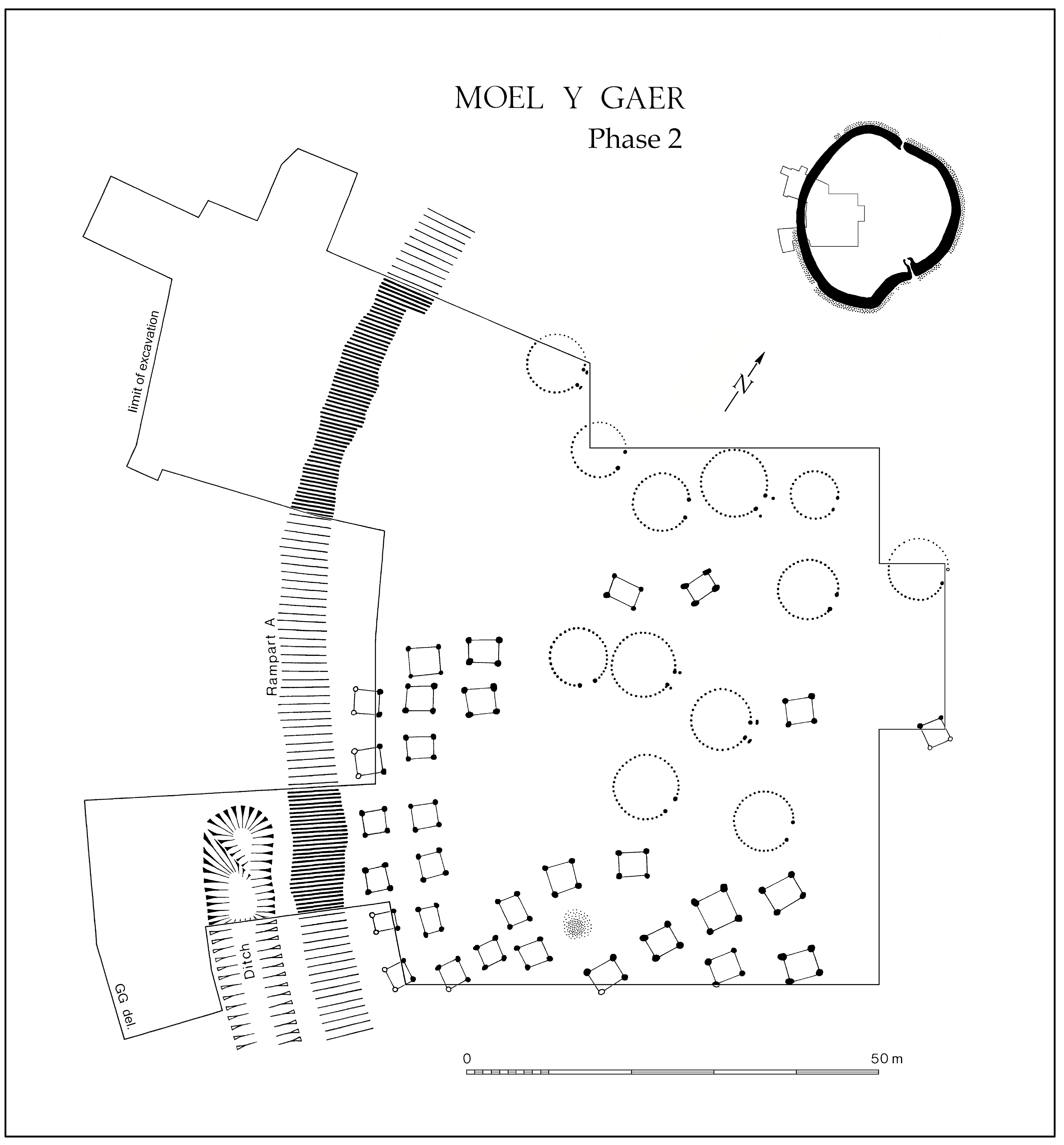
The ensuing hiatus is of unknown duration, ending with a final occupation apparently involving numerous examples of a different kind of rectangular building, requiring no earth-cut foundation and inferred to have rested on sill-beams that sat directly on the contemporary ground-surface. Lying immediately beneath modern humus, it was solely the stony covering of the floors that endured to reveal their positions within more amorphous metalled areas, themselves taken to denote 'outdoor yards' (Guilbert 1976a, 304-6, figs 1-2, pl. IV; 1977b). Conceivably at the same time — and, if so, constituting a Phase 3 alongside the internal metalling — the inner bank was heightened and widened with material scraped thinly from inside the hillfort, before being capped with rubble, possibly designed to anchor a wooden breastwork ('Rampart B' in Guilbert 1975a, 112, fig. 2; 1982, fig. 3.1). The most trustworthy of the radiocarbon dates (HAR-603 = 2190±80 BP and HAR-1562 = 2110±70 BP) were derived from charred twigs of hazel incorporated in a thin silt stratified above some of the Phase 2 four-post structures and below the tail of Rampart B, signifying that the former should antedate, and the latter should postdate, the measured age of those twigs, which falls at some point in the 4th-1st centuries cal BC (95% probability), meaning much of the second half of the Iron Age — unavoidably vague.
Economy of hypothesis would suggest that a seemingly unfinished scheme to convert Moel y Gaer into a bivallate work was devised in company with Rampart B, or shortly afterwards. The low outer bank — at first sight, easily mistaken for a mere 'marker' (Feachem 1971, 20-3) — is actually the embankment of another palisade, this one founded in close-set postholes (Figure J; Guilbert 1982, fig. 3.1). This outer line may have neared completion only where developed into a bigger bank and ditch at the east, but its palisade is known to have been built around more of the circuit than is now evident from the earthworks. It could have resembled a revetment when viewed from outside, making it eminently sensible to raise such a timber facade as the first stage in constructing the intended rampart.
Apart from two documented events — the demise of rebellious Howell Gwynedd (in common cause with his more famous cousin, Owen Glyndwr), reputedly occurring on this hilltop in 1406 (Messham 1968, 21), and the erection of a pair of substantial wooden structures for a fire-beacon during troublous Napoleonic times (as excavated, Guilbert 1975d) — Moel y Gaer seems to have enjoyed quiet stability as unimproved pasture since its prehistoric occupation ceased. This has ensured the good preservation necessary to the greatest archaeological worth of the place, which plainly lies in its wealth of structural information (whereas the main weaknesses include negligible palaeoenvironmental data and a scarcity of datable artefacts, exacerbated by soil acidity, and compounded by imprecision of the radiocarbon dates). It is apparent that both the nebulous manifestations of fully framed sill-beam buildings in Phase 3 and the slender stakeholes of the Phase 2 roundhouses, so too many of the postholes, could not have survived on land subsequently ploughed (Guilbert 1975b, 215-17, fig. 4; cf. section 2.7).
Besides that, several other aspects of the site and its excavation have proved fundamental for comprehending the contrasting characters of the successive settlements, heralding what should be far-reaching consequences. Thus, the relatively stone-free nature of the glacial till covering the chert bedrock (Figures C and K) permitted penetration by the plentiful postholes and, especially, stakeholes within the hillfort (Guilbert 1975b, 217-19), while the opportunity to excavate expansively in autumn and winter facilitated detection of even the slightest structural features (Guilbert 1975b, 217 — a lesson learnt at The Breiddin — Musson and Guilbert 1972). In addition, it is fortunate that discrete occupations (including even Phase 1) seem each to have been sufficiently short-lived, and therefore their remains sufficiently thinly distributed, to allow confident recognition of many individual structures, thereby advancing definition of several structural types, distinguishable through repeated patterns of features. Finally, the chance to excavate stretches of ramparts and palisades is shown to be valuable, not only in itself but also in promoting a cogent inter-relation of the sequence of enclosure with that of the enclosed structures (Figure K; cf. Guilbert 1975a, 115).
Internet Archaeology is an open access journal based in the Department of Archaeology, University of York. Except where otherwise noted, content from this work may be used under the terms of the Creative Commons Attribution 3.0 (CC BY) Unported licence, which permits unrestricted use, distribution, and reproduction in any medium, provided that attribution to the author(s), the title of the work, the Internet Archaeology journal and the relevant URL/DOI are given.
Terms and Conditions | Legal Statements | Privacy Policy | Cookies Policy | Citing Internet Archaeology
Internet Archaeology content is preserved for the long term with the Archaeology Data Service. Help sustain and support open access publication by donating to our Open Access Archaeology Fund.