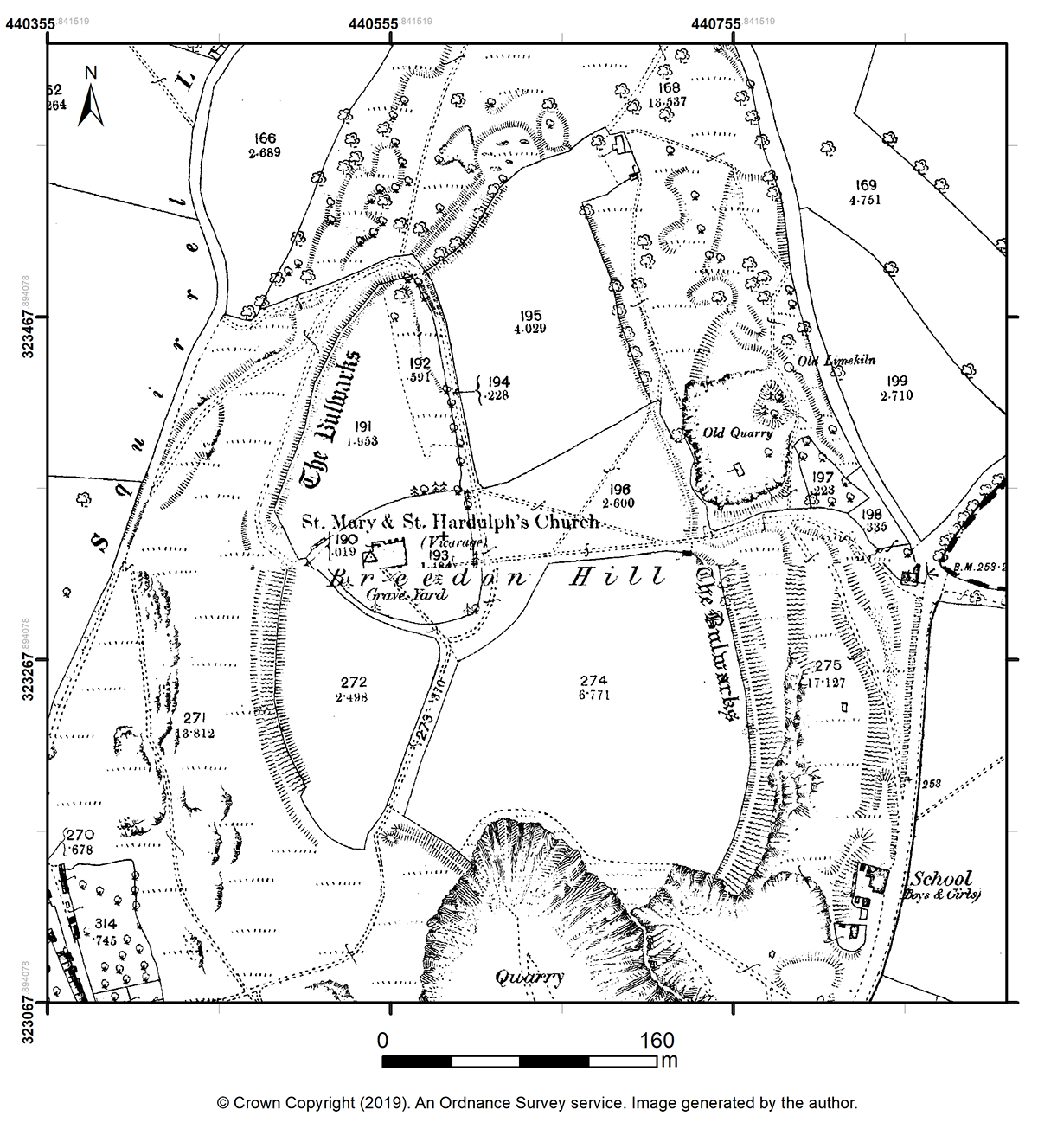
The earliest known survey of the hillfort ramparts was published by the Ordnance Survey in 1882 at a scale of 1:2500 (Figure 3; Ordnance Survey 1882). The map, which served as the basemap for the subsequent programmes of excavation, depicts variations in the form of the earthwork system, prior to the destruction of the eastern half of the hill outcrop. The single bank that enclosed the entirety of the hillfort interior varied in height, width and gradient: it was most pronounced at its south-east, south-west and north-west sides, while the bank in the north-east and east sides (where the hillslope was gentler) appeared to be far less substantial in scale. The earthwork ditch – generally described as heavily mutilated – is not explicitly defined by this map or its later editions, meaning its presence is only known where found through excavation. What was later described as a low 'counterscarp bank' is depicted in the north, north-east, and south-west sides, adjoining the ditch in parallel with the rampart system. The map also depicts the original in-turned entrance in the west side and the other, probably secondary, entrances as breaks in the earthwork system in the south and east sides.
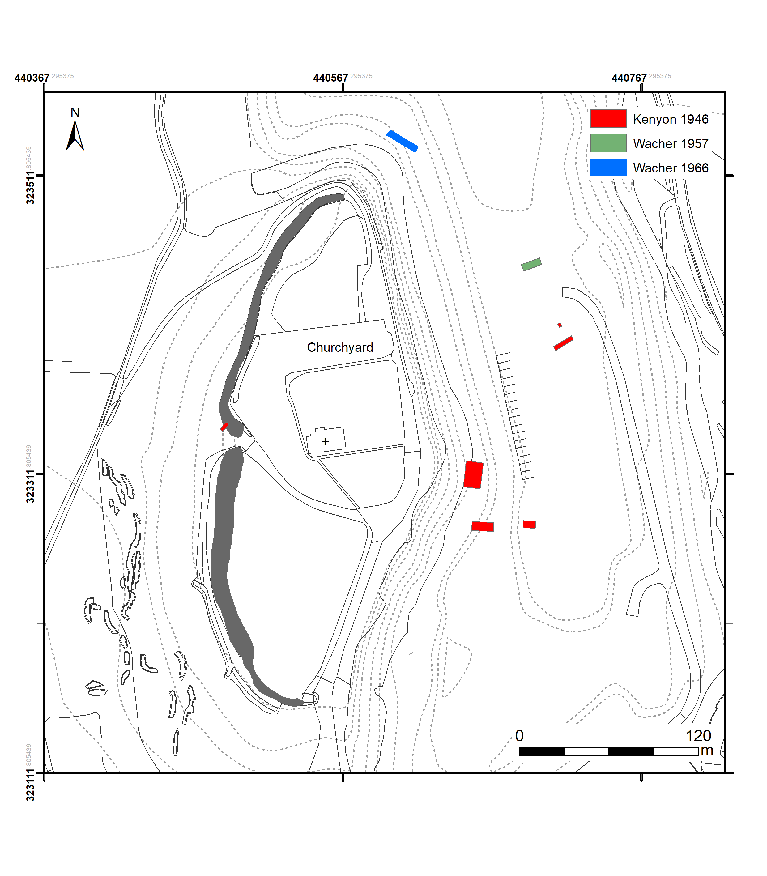
The hilltop has been subject to several small-scale rescue excavations (Figure 4), conducted principally by local archaeologists between the 1940s and 1960s, during a period of intensive quarrying of the eastern half of the outcrop (see Table 1). These sought to 'sample' undisturbed areas of the east side of the hill, and to record features as they emerged at the quarry face. Characteristic of archaeological practice at the time, most of the unpublished investigations listed left behind a very limited stratigraphic or spatial record with which to reconstruct the changing nature and pattern of occupation at the site, especially for those parts of the hilltop now irretrievably destroyed. Almost all of the known interventions into the interior recorded the presence of pits and ditches, which in most cases were filled with occupation debris comprising Iron Age ceramics and animal bone. Between 1961 and 1964, two structures described as 'hut circles' were excavated in an area c.60m NNW of the church, after one was first identified by air photographic survey. Little more is known regarding these features.
As the quarry face encroached northwards, investigations at its southern extent (in Barley Close field) observed the inhumation burials of a monastic cemetery believed to have contained at least 160 skeletons (Geake 1997, 167). The burials were generally observed to cut into the earlier phases of pits and ditches. The unpublished interventions recovered a rich array of material evidence, including Iron Age, Roman and medieval ceramics, iron and bone-crafted implements, beehive and rotary-type querns, fragments of glass beads, and a considerable amount of animal bone.
In 1946, Kathleen Kenyon led rescue excavations (sponsored by the then Ministry of Works) comprising two partial sections into the rampart bank in the east side, a partial section into the north bank of the in-turned west entrance (4.3m long x 1.8m wide), and two interior areas in the field known as Barley Close referred to as Area I and II (Kenyon 1950; 1955).
At the time of investigation, the part of the east bank subject to excavation stood some 3m above the surrounding ground, while the rampart ditch had been heavily mutilated as a result of historical quarrying. Kenyon recorded evidence for a pre-rampart occupation phase in the form of ceramic sherds, bone fragments and charcoal observed beneath the excavated rampart. The excavator proposed that the rampart was constructed in two distinguishable periods: the first construction phase consisted of turf and rubble built up against a timber palisade revetment at the bank's outer face; the second construction phase was defined by the addition of stones and earth above the turf-line, which increased the height of the bank by c.0.5m, then capped by a further turf layer (Kenyon 1950, 20).
The partial section into the northern bank of the western entrance revealed that the bank was constructed of a rubble core revetted at the front by timber uprights. The southern in-turned bank had been levelled by quarrying (Kenyon 1950, 19-20). Part of the upper stone of a Hunsbury-type beehive rotary quern (porous sandstone) was recovered from an area eroded into the original entrance road surface (Kenyon 1950, 41-2).
Kenyon's record of investigations into the interior consisted of two area excavations: 'Area I' referred to square trenches separated by 0.60m baulks (17.7m x 3.0m); while 'Area II' referred to a small exposed area at the quarry face. Excavation at Area II revealed five irregular rock-cut pits and a single posthole (Kenyon 1950, 24). Finds known to have been recovered from the pits include a small three-sided ceramic crucible, a small bone counter incised on one side with six dots, the complete upper stone of a well-used Hunsbury-type beehive rotary quern (all 'Pit II') and a penannular iron brooch with 'crook-shaped' pin ('Pit 4').
Excavation in Area I revealed a large pit (2.44m in diameter) cut by two postholes and a straight gully, which may have formed part of a circular structure. The fills of these features all included Iron Age ceramics (Kenyon 1950, 22). A cuboid-shape bone die incised with dots on each lengthwise face was recovered from the 'pre-graves level'. Twenty-three graves arranged in three rows running north-south, all of which were orientated west-east and in extended positions, were observed cutting these earlier deposits. No grave goods were recorded during the excavation, although one grave (18) contained three iron nails (possibly used to make a coffin), while another (4) exhibited a cairn of stones over the skeleton's head and shoulders. A bronze spiral ring and a bronze attachment plate were, however, found in graves belonging to the part of the cemetery thought to have contained c.160 skeletons, which extended 150 yards (46m) south of Kenyon's Area I (Geake 1997, 167). The organised nature of the graves, and the fact the sequence was sealed by a layer containing medieval ceramics, led Kenyon to suggest that this was a monastic cemetery associated with the early medieval minster (Kenyon 1950, 23-4). A recent study notes further research would be required to validate this conclusion, framing the date of the cemetery between the foundation of the minster (late 7th century) and the date of the medieval sherds (Geake 1997, 167).
In 1957 and 1966, John Wacher excavated sections first into the north-east and then the north sector of the rampart respectively (Wacher 1964; 1976-7). These excavations were engaged principally with the question of the form, development and date of the hillfort's earthworks. The section through the north-east rampart and ditch added detail to the understanding of the earthworks, demonstrating that the outer face of the rampart bank stood at a height of 3m above a 2m wide berm that used the hilltop's natural slope. At its full extent the ditch spanned some 8.2m wide, cut to a depth of 3.7m – flattening at the bottom for some 3m – below the foot of the rampart. A gentle counterscarp bank at the outer lip of the ditch, which appeared to be unrevetted, was made up of limestone rubble (Wacher 1964). In a similar line to that of Kenyon's excavations, Wacher concludes that the timber revetments at the face and tail of the ramparts, comprising the first phase of construction, were replaced by turfwork and a dry-stone wall revetment in a second phase (1964, 122-26). A group of four saddle querns were recovered, made of varied local stone types (1964, 132-5; Roe 2000, 189).
A decade later, Wacher's report on the 1966 excavations into the northernmost earthworks (Wacher 1976-7) reconsidered the conclusions previously put forward concerning the rampart's form and construction phases. The excavators observed that postholes set 0.6m apart into the natural rock, also observed in the east rampart and interpreted as an inner timber rampart revetment (Wacher 1964), were not in contact with the rampart bank in the north, which was instead revetted with large boulders (Wacher 1976-7, 2). As such, Wacher proposed with some confidence that the postholes supported a free-standing timber palisade enclosure that pre-dated the rampart construction, a possibility raised tentatively by Kenyon in 1950. The postholes would have supported palisade timbers standing up to 2.4m above ground level. The rampart was then constructed outside of the palisade enclosure, which was reused at the east rampart to support the weight of the earthwork bank, functioning as an inner timber revetment. Wacher noted that no secondary work or adaptation to the bank – as observed in 1946 and 1957 in the form of a turf revetment replacing the (perhaps rotting) timbers – was apparent at the north rampart (1976-7, 3). Based on these observations, Wacher reconsiders his previous assessment, arguing that the turfline revetment observed in 1946 and 1954 instead represents a local repair, rather than a discrete secondary construction phase, and so concludes that the rampart should be seen as a single-phase construction (1976-7, 3).
For the excavator, there was insufficient stratified evidence to provide a firm date for the construction of the palisade enclosure – although the middle or late 2nd century BC is suggested – or for the main rampart phase (Wacher 1976-7, 5). A miniature oval-shaped bronze shield with leather thong discovered below the counterscarp bank is thought to provide a terminus post quem of the 1st century BC for the bank's construction, which was considered to be contemporary with the bank and ditch system (Wacher 1976-7, 6-7). Recent research on objects of this kind from Lincolnshire, however, suggests miniature shields belong more broadly to the Late Iron Age and early Romano-British periods (c.100 BCE-100 CE) (Farley 2011). The life-span of the two main phases of defences is thought to be around a century (Wacher 1976-7, 6). The parts of three saddle querns were recovered (1976-7, 7).
In 1975, Ann Dornier conducted excavations within the modern churchyard directly north and north-west of the church, although the scale and precise location of the investigations were left unrecorded (Dornier 1977a; Webster and Cherry 1976, 165, 178).
The discoveries considered to be associated with the Anglo-Saxon minster were published in a review paper on that topic, which omitted the findings of other periods (Dornier 1977a, 164). Investigation in the north-west corner of the churchyard recovered a rectangular bronze buckle plate or clasp with enamel cloisonné, thought to have been part of an 8th-century belt shrine of Irish influence or manufacture, an 8th-century 'Porcupine'-type Sceat (silver coin) inscribed '+ LEL', and early medieval ceramics considered to have been made in France or Belgium (Dornier 1977a, 162-6). The excavation north of the church revealed three building phases and a wall, interpreted as part of the kitchens and the precinct wall of the Augustinian priory, which existed from pre-1122 until 1539 (Webster and Cherry 1976, 178).
| Date | Investigator | Intervention type | Location/grid reference | Reference | Summary |
|---|---|---|---|---|---|
| April 1942 | Revd J.W. Burford | Excavation | Interior | – | Single extended inhumation burial without objects cut into limestone; proximal to pits and ditches thought to be of Iron Age date. |
| August 1942 | Revd J.W. Burford | Excavation | Interior | – | Six skeletons without objects orientated east-west, partially cut into shallow pits of Iron Age date. |
| 1944 | – | Excavation | – | – | Single pit feature 'Pit 8' measuring 5 x 4 x 2ft (1.5 x 1.2 x 0.6m) interpreted as a hearth; finds included a cooking pot, a (partly burnt) human skull, part of a glass bead, and a single microlith excavated above hearth layer. |
| 1945 | F. Cottrill (Keeper of Archaeology, Leicester Museum) | Excavation (several episodes) | Interior | Recorded finds included in Kenyon's 1950 report | Several pits and ditches cut into limestone rock, with fills including 'Late' Iron Age ceramics, a beehive quern, glass bead and iron metalwork; several inhumation burials later than the pit-and-ditch sequence. |
| 1946 | Kathleen Kenyon | Excavation | Rampart -
Cut A (E side): SK 40720 23402 Cut B (NE side): SK 40713 23412 Cut C (W entrance): SK 40487 23343
Interior – Area I: ?SK 40654 23311 Area II: ?SK 40660 23276 | Kenyon 1950; Kenyon 1955 | See this article |
| November 1947 | Revd J.W. Burford | Excavation | Interior (quarry edge) | – | Three pits excavated, filled with ceramic sherds and animal bones. |
| 1947 | J.K. Jobbins | Excavation | Interior (quarry edge) | – | Two inhumation burials and non-associated pottery sherds. |
| 1948 | – | Excavation | Interior (quarry edge) | – | Single pit ('Pit 10') excavated with circular sloping floor and perpendicular sides; filled with animal bone (showing knife cuts) and ceramics; possible medieval glass may have come from the top of the fill. |
| 1949 | – | Excavation | Interior | – | Single pit ('Pit 11') described as shallow, roughly circular and basin-shaped measuring 7ft diameter x 2ft' deep (2.1m x 0.6m), filled by animal bones and pot vessels. |
| 1949 | Revd J.W. Burford | Excavation | Interior | – | A series of pits associated with a 'Y-shaped' ditch, the fill of which included an iron bolt/harness and part of a skull. |
| 1951 | – | Excavation | Interior | - | A single pit ('Pit B') containing a spearhead and bone. |
| 1955 | Don Brothwell | Excavation | – | – | At least two skeletons in 'shallow rubble- filled cradles' cut into the limestone; artefacts attributed either to these burials or to the many other burials left unrecorded around this time include a ring and a metal fastening, interpreted then as 'Saxon' in origin owing to its state of preservation. |
| 1957 | John Wacher | Excavation | NE side of rampart (SK 40693 23452) | Wacher 1964 | See this article |
| 1959 | – | Proton magnetometer survey | – | – | |
| 1961 | S.E. Thomas (with James Dyer) | Excavation | E side of the rampart (approx. SK 40698 23465). Trenches into the W end of churchyard | E. Midl. Arch. Bull. 1961, 4, 5-6 | East rampart partial section: no postholes were found at the rear of the rampart, as described by J. Wacher in 1964. Finds from the rampart section include fragments of a small and a large sword; from various pits excavated an iron knife and tang, and a quern stone. Churchyard excavation: wall foundations and burials revealed, interpreted as 'monastic remains'. |
| 1962 | – | Proton magnetometer survey | Interior | – | A sketch drawing of the results tentatively suggests presence of pits, part of ditches and areas of burning. |
| 1961-3 | A.J. Pickering and Leicester Museum staff | Aerial photographic survey and excavation | Interior (SK40600 23400) | Trans. Leic. Arch. Hist. Soc 1963-4, 39, 50 | A roundhouse was revealed by air photographic survey, which was subsequently excavated by Leicester museum staff revealing several pits, postholes and ditches. |
| 1963-64 | Leicester Museum staff | Excavation | Interior (SK 40593 23393) | Trans. Leic. Arch. Hist. Soc 1965-6, 41, 66 | A further roundhouse and several pits were excavated 200ft (61m) NNE of the church. |
| 1964 | D. Reaney | Excavation | Interior (SK40600 23500) | E. Midl. Arch. Bull. 1964, 7, 5 | – |
| 1966 | John Wacher | Excavation | N side rampart (SK 40607 23535) | Wacher 1976-7, 1-35 | See this article |
| 1975 | Ann M. Dornier | Excavation | NE corner of the churchyard (approx. SK 40510 23380) N of the church (not specified) | Dornier 1977b; Med. Arch. 1976, 20, 165, 178 | Excavations in the modern churchyard recovered an early medieval bronze buckle or book clasp with key-pattern enamel inlay, a bronze stylus, an 8th-century coin, and late Saxon and Saxo-Norman pottery. N of the church: observed three building phases of the 'kitchen block and precinct wall' Augustinian priory. |
| 1987-1988 | Leicestershire Archaeology Unit | Excavation | SK40560 23350 | Trans. Leic. Arch. Hist. Soc 1988, 62, 74 | c.70 post-medieval burials excavated at the south and east side of the church. A late medieval wall recorded at the church's east end may 'represent the remains of a boundary wall separating the monastic and lay communities within the graveyard'. |
| October 2014 | Neil Finn (Archaeology and Built Heritage) | Watching brief | SK40539 23339 | pers. comm. | Watching brief conducted during the installation of a trench arch drain within churchyard along the line of the path NW of the surviving building: 'the trench was cut through a deep rubble deposit which was presumably debris from the demolition of priory buildings, though no in situ masonry was observed'. |
Cite this as: Whittaker, C. 2019 Breedon Hill, Leicestershire: new surveys and their implications, Internet Archaeology 52. https://doi.org/10.11141/ia.52.6
Internet Archaeology is an open access journal based in the Department of Archaeology, University of York. Except where otherwise noted, content from this work may be used under the terms of the Creative Commons Attribution 3.0 (CC BY) Unported licence, which permits unrestricted use, distribution, and reproduction in any medium, provided that attribution to the author(s), the title of the work, the Internet Archaeology journal and the relevant URL/DOI are given.
Terms and Conditions | Legal Statements | Privacy Policy | Cookies Policy | Citing Internet Archaeology
Internet Archaeology content is preserved for the long term with the Archaeology Data Service. Help sustain and support open access publication by donating to our Open Access Archaeology Fund.