3.0 What Three-Dimensional Modelling Packages offer
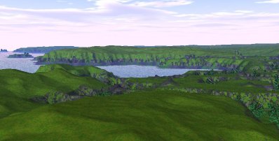
After capturing data and generating a 3D model of an object, that model can be relatively easily combined with a landscape surface model generated from a digital elevation model (DEM). Once the geometry of the model and landscape is satisfactory other factors such as lighting conditions representing the weather, time of day and so on, can be manipulated to create almost any desired effect. Similarly the level of control of the model in the modelling environment allows for reconstruction of archaeological landscapes features such as past tree cover or buildings (Fig. 3) as well as reconstruction of missing or damaged segments of a sculptured stone.
Figure 3: A landscape generated with GenesisII software from a basic Digital Elevation Model. Despite the accuracy of the surface topography, the surface detail such as rocks, vegetation and so on are computer-generated. As such they follow the software algorithms for this type of detail generation rather than representing detail captured from the actual landscape
How a wider audience accesses models generated in 3D modelling packages can be problematic. Depending on the originating application, the models may only be viewable either in the original application, as exported animations or in specialist 3D graphics viewing software. However, most 3D modelling packages will allow for the translation of the model into VRML, a presentation format which has been extensively written about in Internet Archaeology (Gillings and Goodrick 1996; Terras 1999) and elsewhere, and has the especial benefit of allowing any user with an appropriate Internet browser plug-in to examine the model interactively, although there is a pay off between interactivity and level of detail and many plug-ins are hard for the uninitiated to work with. Even if VRML does not survive as the de facto standard for presenting simple VR/3D information over the Internet (and there is some doubt that it will) there is little doubt that similar languages or file formats, such as QSplat (Rusinkiewicz 2000), will replace it.
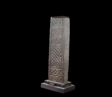
Figure 4: The Govan Cross. Select the above image for an example (Figure 10) of a three-dimensional model generated using photogrammetric techniques and presented for the Internet via VRML.
This example requires a VRML enabled browser or a browser plug-in (client), such as Cortona
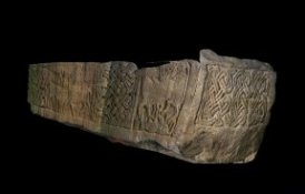
There are some problems with three-dimensional modelling as an approach to landscape representation, not least of which is the difficulty in rendering surfaces with sufficient detail and texture to give the impression of photorealism. However, this is possible for models of geometric objects where each surface can be rendered directly from photographic images. Satisfactory results can also be obtained for more complex shapes, but only if the texture maps used for rendering are generated in a package which will distort base images to compensate for known surface geometry. An example of this might be the creation of texture maps in a photogrammetric package that are then imported, as part of the model, into a three-dimensional modelling package (Fig. 5 a & b). This is the technique that has been used in the example of the Govan Cross used in this article. What is more problematic is the rendering of landscapes. The most common approach is to use generic landscape rendering. This, depending on user-defined levels of complexity, can give a very realistic impression of vegetation, rocks and so on. The types of vegetation or the occurrence of outcrops are often generated in relation to the height given by the DEM; this way the user can define at what height the tree level might be or at what steepness grass gives way to cliff. However, the problem is that this realistic impression is only loosely related to what the landscape actually looks like. If there is a rock outcrop at a particular location and this requires rendering with a different texture map to make it apparent in the model, then this has to be done explicitly by the user. What this means is that to achieve a surface rendering that is not just photorealistic but actually a realistic representation of the landscape, a great deal of time and effort is required.
Figure 5 a & b: 5a (on the left) is of a plainly rendered polygon surface generated in PhotoModeler Pro. 5b (on the right) shows the same surfaces rendered with bitmaps derived from the original photographs of the monument. An example of the high resolution base images used is available from the SEMSS website
As already indicated above, decisions have to be taken by the user at various stages in model construction regarding the number of points and polygons that will satisfactorily represent a landscape. Visually, good results can be generated with fairly poor levels of surface detail provided the rendering is complex enough and effectively breaks up the blocky, geometric impression given by a fairly coarse polygon structure. However, poor levels of surface detail, i.e. widely spaced points or contours, will obviously result in a less accurate result, no matter how realistic the rendering package makes it look. This problem, in combination with the difficulties of landscape rendering mentioned in the last paragraph, often means that in all but the most sophisticated models the landscape is neither highly accurate nor does it have the 'look and feel' of a real landscape.
A far more difficult problem for three-dimensional modelling packages that are intended to represent an archaeological landscape is the problem of the horizon. If the horizon or far distance is significant to the understanding of the landscape, for example, which hill or mountain tops can be seen, or whether the sea can be seen from a particular location, then a DTM/DEM may have to be very large indeed to cover the entire geographical zone that is visible from the area of interest. The fact that the horizon is either completely false or impressionistic in many models used for civil engineering or architectural purposes has little relevance to their usefulness in these contexts. However, the significance of the horizon for defining a place in anthropological terms and the importance of the visibility of distant places in the historical past (Ingold 1997, 29-32; Lemaire 1997, 5-22) means that the inclusion of an accurate horizon could be as crucial in the creation of a virtual world as it is in the social construction of the real world.
Finally, the complexity and sophistication of three-dimensional modelling packages tend to mean that a further two important factors come into play with regard to their suitability for this type of archaeological project. One is the cost of the packages themselves, frequently upwards of a thousand pounds, plus the cost of the hardware required to run them in a satisfactory manner. This hardware is almost always far more powerful than the minimum requirements specified by the developer, who have a vested interest in underplaying this aspect of their product as it represents an added cost to the user from which they, as software developers, will not benefit. The second factor is the usability of the packages. Again, the complexity and sophistication of the package mean that considerable time and effort needs to be invested in getting to know how to use the package, and much more time to take full and efficient advantage of all that it may offer.