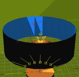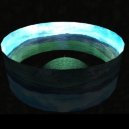

Figure 7 a & b: Screen shots showing the cylinder and projected image inside 3D Studio Max with the photogrammetrically generated model (7a - left) and a fragment of landscape at its centre (7b - right)
To try to reconcile the features of both technologies, I have developed a technique that uses these two technologies in combination. In the example used, I have a 3D model of a cross generated by photogrammetry. The cross is incomplete and is currently housed indoors. This is an especially relevant example because of the number of early medieval sculptured stones that have already been moved out of context in antiquity or have recently been moved, mostly indoors, because of environmental pressure. I also have a QTVR panorama of a location where the cross may have originated (in this case we know that the cross did not originate from this particular location and it is being used for demonstration purposes only).


Figure 7 a & b: Screen shots showing the cylinder and projected image inside 3D Studio Max with the photogrammetrically generated model (7a - left) and a fragment of landscape at its centre (7b - right)
This new technique involves using a 3D modelling package, in this case 3D Studio Max from Autodesk, to create a cylinder and then taking a stitched and blended QTVR panoramic tile, which has been distorted to allow for parallax effect, and projecting it (i.e. selecting it as the rendering image) on the inside surface of the cylinder (Fig. 7 a & b). The panoramic tile is best generated using QTVR authoring tools, but a potentially acceptable tile could be created by generating the panorama in an image handling application like PhotoShop. The proportions of the cylinder must be calculated carefully to ensure that the full 360 degree span of the panoramic tile is projected on the inside of the cylinder. In order to do this the width of the panoramic tile is used as the inside circumference of the cylinder. It is then possible to place 3D models of individual monuments and/or parts of their associated landscape at the centre of the cylinder. Virtual cameras, used by modelling packages to give viewpoints, are then positioned inside the cylinder and, as long as their field of view is normal to the inside surface of the cylinder, this gives the appearance of the model being in the landscape represented by the panorama. The vertical position of the cylinder relative to the model can be manipulated to gain the desired effect. For example, if there is a fairly large landscape surface model inside the cylinder a combination of camera position, model position and cylinder height can be used to align the model with the landscape projected on the cylinder. A small landscape model, say, one that just gives only the immediate ground around a monument (as Fig. 9 a & b) could utilise almost the full vertical extent of the panoramic tile. Care must also be taken to ensure that the model and cylinder are in the correct orientation relative to each other and to the internal orientation of the modelling package if 'time of day' natural lighting effects are to be used.


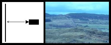
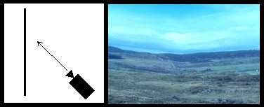
Figure 8 a & b: Two images taken with the virtual camera in two different positions to demonstrate the distortion effects if the camera is not pointing directly at the cylinder wall.
8a (top): With the camera normal to the cylinder wall, there is no distortion of the landscape.
8b (bottom): With the camera angled, the landscape distorts
This approach presents two obvious possibilities for archaeological landscape reconstruction. Firstly, QTVR object movies and panoramas can be generated using the three-dimensional model with the reconstructed monument back in context, without the problems of camera angle control mentioned earlier (Fig. 8). Secondly, 3D 'fly-by' animations can be created using detailed DTM/DEMs for the local area but with the far distance represented by the photorealistic panorama, although in this case care would have to be taken with the angle of the camera. Unfortunately, VRML resolution is not high enough to present the model and cylinder sensibly in an interactive viewer, and in any case interactivity would have to be constrained to stop the user from tilting the camera angle and spoiling the effect. The fact that QTVR object movies can now be generated (with a genuine photographic landscape panorama) from a series of images generated by the 3D modelling package allows for a fairly high degree of interactivity. The user is able to zoom in and out of any part of the image, to slide the image in the window when zoomed in. Most significantly, the user is able to 'walk round' the monument by rotating it whilst at the same time observing the surrounding landscape to the horizon (Fig. 9).
© Internet Archaeology
URL: http://intarch.ac.uk/journal/issue10/jeffrey/section5.html
Last updated: Wed May 16 2001