Select map to retrieve all Torksey ware from dataset

During April 1989 field walking was undertaken for Humberside Archaeological Unit by Peter Didsbury and members of the East Riding Archaeological Society (Didsbury 1990). A total of 123 worked flints, 86 fragments of bone, weighing 580g, and 112 sherds of pottery, weighing 959g, were recovered from the field to the west of Burrow House Farm. The largest group of pottery was Roman (40.2% by sherd number), followed by post-medieval to modern wares. The only ceramic material identified as belonging to the period between the fifth and twelfth centuries consisted of two sherds of Torksey-type ware. The finds and field walking archive were transferred to the Department of Archaeology, University of York, and have now been incorporated within the Cottam project archive (site code COT89).
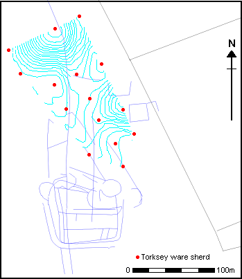
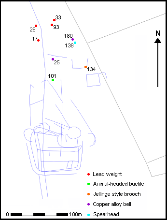
In mid-January 1993 part of the north area of the same field was gridded for field walking. This incorporated the area which had produced the bulk of the metal detected finds. The field walking recovered an extensive collection of flint flakes of Bronze Age or earlier origin, together with a few flint artefacts. There was a concentration of blades and points to the north of the field walking area which may indicate a focus of prehistoric activity in this area. During subsequent excavation a sherd of collared urn was found in the surface of a major north-south ditch in COT93.1; this is unlikely to have moved far and may have come from a ploughed-out barrow which is thought to lie in this field (Terry Manby pers comm). Romano-British greywares and Huntcliff wares were distributed across the whole area walked. This may relate to settlement but there was no other obvious Romano-British material apart from the pottery. The early medieval material, including both York and Torksey type wares (see figure 25), was concentrated almost exclusively to the north-east, coinciding with the distribution of tenth-century metalwork (figure 26). Finally, there was a small amount of medieval and post-medieval material which seems to be mostly distributed in the eastern area. This is probably the result of manuring, and its distribution is probably related to the location of the present farm.
Figure 25: Trend surface distribution map of Torksey Ware and York Ware recovered by fieldwalking in 1993
Select map to retrieve all Torksey ware from dataset

Figure 26: Distribution of tenth-century metal objects
Select a find to connect to its entry in dataset

Three excavation trenches were subsequently opened within the area which had been fieldwalked and the significance of both the flints and the pottery recovered from field walking in 1993 is discussed elsewhere.
© Internet Archaeology
URL: http://intarch.ac.uk/journal/issue10/richards/fwk.html
Last updated: Tue May 15 2001