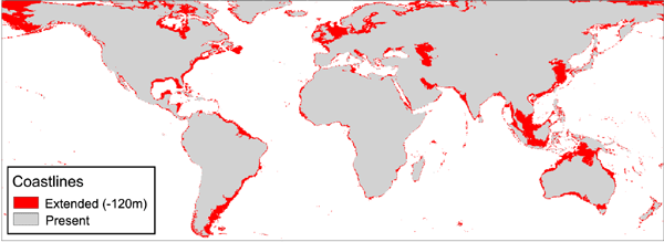
Figure 1: LGM extended coastlines
Due to the extent of the ice sheets during LGM, coastlines were dramatically changed in certain areas as a result of the drop in sea-level. Based on coral cores, a common accepted mean value for this drop is about 120m (e.g. Fairbanks 1989), even though this change was locally higher or lower, due to the glacio-hydro-isostatic contributions to sea-level (Lambeck and Chappell 2001).
To our knowledge, there is no available global map of LGM coastlines. Most authors mapping LGM environments have used bathymetric data sets to reconstruct the shorelines of the area of interest based on the accepted sea-level drop value of 120m. We used the global sea-floor topography data set (version 8.2)), compiled by Smith and Sandwell (1997). The data set is at 2 arc-min resolution (about 4km at the equator). Since the data set was originally in the Mercator projection, we used standard ArcView tools to reproject the data set to geographic projection. For a more convenient use, we also changed the original extent of the data set (0 to 360 decimal degrees) to -180 to +180 decimal degrees. A simple legend reclassification of the values highlights the 120m depth contours (Figure 1), allowing the modification of the vegetation boundaries accordingly.
Figure 1: LGM extended coastlines
This contour map was compared with a recent map of south-eastern Asia that was compiled from a wide array of sources, taking into account tectonic information when available (Voris 2000). Unfortunately, this map was not available in electronic format, so we were not able to compare the differences within the GIS system. However, a simple visual comparison showed only a few areas where the differences between the two maps were noticeable at this scale. These differences were relatively small, in the order of 20-50km. This encouraged us in the view that the global bathymetric data set is appropriate to generate a global map of past coastlines, providing the approximations inherent in this approach are accepted. We thus corrected our initial vegetation map to fit these LGM coastlines using the standard digitizing tools in ArcView.
© Internet Archaeology
URL: http://intarch.ac.uk/journal/issue11/2/3.4.html
Last updated: Mon Dec 3 2001