Figure 2: Location of Parliament Street site - select to view location of trench
From Brinklow (ed) 1995
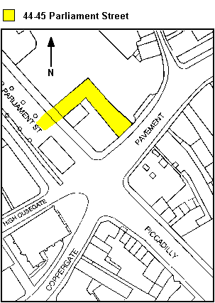
The archaeological interventions at 44-45 Parliament Street (Fig. 2) consisted of two separate exercises. The first was the archaeological evaluation trench excavated by the York Archaeological Trust (YAT) in November 1994. The second consisted of the re-excavation of the backfilled evaluation trench and the excavation of a trench 13 x 1 x 0.75m deep in order to allow the installation of the monitoring devices (Fig. 5). The formation of the boreholes was also monitored by the Environmental Archaeology Unit and YAT. More details about the Deposit Monitoring Project are available from CYC's own webpages.
A single trench, 3 x 3m, was hand-excavated to a depth of 2m. The nature of the deposits encountered allowed much of the material to be removed in spit form, with features being excavated in detail when they were encountered. This may have led to finds from the upper fills of pits being incorporated into layers which were thought to seal the features. However, these possible inaccuracies are not thought to have a severe effect on the conclusions presented in the evaluation report.
Figure 2: Location of Parliament Street site - select to view location of trench
From Brinklow (ed) 1995
The standard York Archaeological Trust single context recording system was employed, with finds being recorded by context, and selective environmental sampling being undertaken, following consultation with the Environmental Archaeology Unit, University of York. The finds and site records are currently stored with the York Archaeological Trust under the Trust and Yorkshire Museum accession code YORYM: 1994.3210.
The trench was opened with a concrete floor saw and pneumatic breakers, to remove between 0.60m and 0.75m of modern material. This consisted of two separate concrete surfaces with a brick rubble base adhering to the under-side of the upper, steel-reinforced one (1000). A substantial void (up to 0.20m thick in places), between the rubble base and the lower concrete floor (1001), suggested that this surface had sunk into the underlying deposits (Fig. 3).
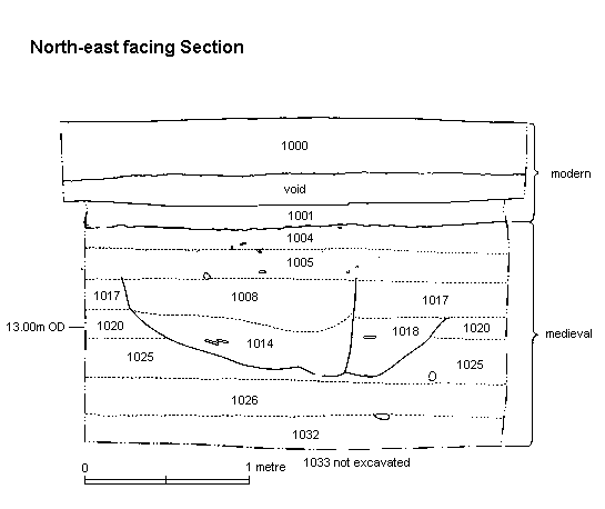
Figure 3: North-east facing section
From Brinklow (ed) 1995
These underlying deposits and features will be described chronologically, from the bottom upwards. The earliest deposit encountered was a mid-brown clay silt, with lenses of ash and charcoal, and a characteristically high organic content (1033). This was not excavated since it was located at the 2m depth limit of the trench at 12.30m OD. (Open section in new window for cross-referencing.)
Overlying this, except where later intrusions had caused truncation, was a dark-grey clay silt (1032), up to 0.15m thick. This also contained ash and charcoal lenses but in greater quantity, and fragments of industrial waste were also present. Off-cuts of antler and horn were found in substantial quantities. Cut into 1032 were two features (1029 and 1031).
Context 1031 was a shallow 'bowl-shaped' pit, which continued beyond the south-east edge of excavation, and was truncated by a later intrusion to the north-east. The surviving slope suggested a sub-circular shape, with a maximum diameter of 1.25m, and a depth of 0.25m. The primary fill was a yellow-grey clay silt, with large quantities of ash and 'cessy' inclusions (1030). This was sealed, filling the cut, by a concreted reddish-brown organic silt (1028) suggestive of cess or manure.
Context 1029 continued beyond both the north-west and north-east edges of the excavation and was severely truncated by a later intrusion (1022). The remaining part measured at least 1.70m x 0.60m with very steep sides. It was filled with a mid-olive brown clay silt (1027) which was concreted around the edges, loose in the centre, and contained few inclusions. This fill was not fully excavated, owing to depth restrictions. The north-west trench section suggested that this pit was originally cut from a higher level and that 1027 was a primary fill, probably cess, and was sealed by a dark-grey clay silt backfill.
Sealing the two pits was a 0.20m thick deposit of dark-grey clay silt (1026), with a concentration of leather in the east corner, and numerous other inclusions representing refuse (e.g. bone, tile, and shell). This was overlain by a similar deposit, about 0.25m thick, which contained more bone but less leather (1025). Two features cut into 1025. The earliest (1024), was very shallow and continued beyond the south-east edge of the trench. This may simply represent a depression, or the start of a slope, in the surface of 1025. It was filled with dark-grey brown silty clay, (1023), with concreted edges, suggesting high organic content. Also cutting 1025 was a major intrusion (1022), which continued beyond the north-east and south-east edges of excavation. It was at least 2.30m long by 0.35m wide and was more than 0.70m deep, when excavation stopped at 2m below ground level. The fill was a mid-brown grey silty clay (1021) containing quantities of shell and animal bone, suggestive of domestic refuse.
Context 1021 was sealed by dark-grey clay silt (1016) about 0.20m thick along the south-east end, and a further dark-grey clay silt (1020), across the majority of the trench. Both contained bone, shell, tile and limestone fragments.
Context 1020 was cut by a semi-circular shaped pit (1019), which was approximately 0.50m deep and extended beyond the south-west edge of excavation. The fill was a dark grey-brown clay silt (1018), with concreted edges, suggesting cess.
This pit was sealed by a dark-grey clay silt (1017), containing quantities of bone, shell, tile and limestone, similar to earlier layers (e.g. 1020 and 1025). Along the south-east edge of the trench this material was recorded as 1013, because of its separation by later intrusions.
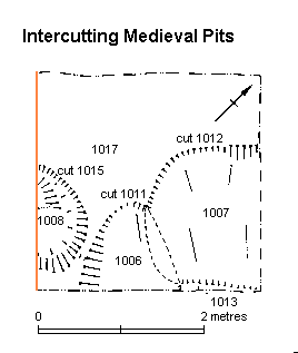
Figure 4: Intercutting medieval pits (north-east facing section marked on left-hand side)
From Brinklow (ed) 1995
Cut into 1013/1017 were three major pits (Fig. 4). Contexts 1011 and 1012 were inter-cutting, but the similarity of their fills (1006 and 1007) prevented their precise chronology from being ascertained. Context 1011 continued beyond the south-east edge of excavation, but was at least 1.00 x 0.90m in plan, and 0.40m deep. It had steep sides, a flat base, and was filled with a mixed yellow-brown clay silt (1006), with lenses of ash and clay, fragments of tile and limestone, and quantities of bone and mortar. Context 1012 continued beyond the north-east edge of excavation. It was sub-rectangular in shape, measured 1.50 x 1.60m and was 0.45m deep. Like 1011, it had steep sides and a flat base. The fill (1007) was almost identical to 1006.
Pit 1015, cut from the same level, continued beyond the south-west edge of excavation. It was semi-circular in plan, 1.30 x 0.70m, and 0.55m deep, with an almost vertical north edge and a more gently sloping east edge. The primary fill was a light-grey silty clay (1014), with possible cessy concentrations around the edges. This was sealed by a mixed yellow-brown clay silt (1008), with lenses of ash, clay and charcoal-rich silt, together with tile and animal bone.
During the excavation of pits 1011, 1012 and 1015, a substantial quantity of poorly preserved wood (1010) was encountered. This was probably the remains of a major tree-root, which had disturbed the stratification, although its date is uncertain.
Sealing the three pits was approximately 0.35m of mixed dark-grey clay silt (1004, 1005) containing ash, mortar, bone, tile, limestone, shell and clay lenses, all of which suggested that these were dumped or build-up deposits. The surface of 1004 lay directly below concrete surface 1001.
The upper surface of 1001 exhibited a degree of undulation, with the total difference in level being as much as 0.15m. Built into this surface was a short stub of wall, orientated south-west to north-east, at right angles to Parliament Street. This may represent an internal dividing wall within a building erected along this 19th century street.
The following year, a trench of 3 x 3m was opened to a depth of about 2m by YAT at approximately the position of the 1994 evaluation trench. Samples of sediment were collected by EAU staff from the open sections at the positions shown in Figs. 4, 5, 6 and 7, and stored in 10 litre plastic tubs. The sampled faces were cut back by about 10cm to remove freshly dehydrated and potentially contaminated sediment. During sampling, it was noted that voids (of the scale of a few millimetres width and up to a few centimetres in length) throughout the sections had been infilled with a white microcrystalline 'efflorescence', which was sampled from several locations.
Additional samples were obtained during a programme of boring by Geodrive Ltd within the former Currys shop and through the pavement of Parliament Street to the west of the shop frontage. The cores were sampled as fully as practicable in the field.
© Author(s). Content published prior to 2013 is not covered by CC-BY licence and requests for reproduction should usually go to the copyright holder (in most cases, the author(s)). For citation / fair-dealing purposes, please attribute the author(s), the title of the work, the Internet Archaeology journal and the relevant URL/DOI.
Last updated: Wed Mar 6 2002