![]()
![]()
![]()
![]()
The distribution map is a mainstay of archaeological enquiry. Patterns of material cultural are easily recognised and understood through this visual medium. While statistical analysis is important to verify correlations between artefacts, places and geography (to name a few), nothing beats the distribution map for its clear display of data (assuming it is well presented!). The distribution map has gained a reputation in some circles for being part of the 'processual tool-kit' and is therefore not employed to its full potential within 'post-processual studies'. This is unfortunate, as it is an elegant tool of analysis.
Distribution maps have been primarily used to display correlations between places and things: which artefacts are located next to a river; which sites are located on terrain one hundred metres or more above sea-level; which places are associated with what buildings etc. When distance calculations are needed (for instance, the area of distribution of pottery within a region), they are usually done by Euclidean measurements - or "as the crow flies". This can be useful in terms of relating patterns of material culture to present-day spatial representations by using a Mercator projection on maps, with their political boundaries and our conception of distance by car, train or plane. It is not so useful when the researcher wishes to understand more about movement between communities a thousand years ago.
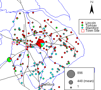
Figure 1: Distribution of Anglo-Scandinavian pottery in Lincolnshire
Select to open interactive map in a new window (requires Java)
The standard distribution map gives the researcher a sense of scale and the territorial extent of trade as seen from the distributions from three pottery production centres in Lincolnshire: Lincoln, Torksey and Stamford (Figure 1) [2]. As can be seen, there is a concentration of Lincoln products to the north. Torksey ware trade is focused along the Trent and towards Lincoln. The Stamford ware distribution extends throughout the county, but again sites with high numbers of Stamford ware are situated in the southern part of the county. These territorial distributions have been discussed elsewhere (Symonds 1999; in press).
The pottery produced in Lincoln will be the focus of the analysis and discussion in this article. The Lincoln wares have the best representation in the East Midlands Anglo-Saxon Pottery Project (EMASPP) database. Owing to the political limitations of the EMASPP data collection, which has been confined to Lincolnshire, the distribution of Torksey ware outside of Lincolnshire is difficult to determine. Torksey ware is thus represented by a relatively small number of sites. Furthermore, there is a sparse representation within the EMASPP database of sites near to Stamford, although Stamford ware was heavily traded in that area (Kilmurry 1980). Therefore, this article focuses on the Lincoln pottery production and its distribution. Discussion and analysis of Stamford ware and Torksey ware industries can be found elsewhere (Symonds 1999).
![]()
![]()
![]()
![]()
© Internet Archaeology
URL: http://intarch.ac.uk/journal/issue13/1/3.html
Last updated: Wed Nov 13 2002