![]()
![]()
![]()
![]()
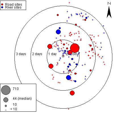
Figure 12: Cognitive distribution map of Anglo-Scandinavian pottery produced in Lincoln
Select to open interactive map in a new window (requires Java)
The clustering of sites within one to two days travel is clearly demonstrated from the cognitive map representing the amounts of Lincoln wares according to distance and time measurements along the Roman roads (Figure 12). Most of the sites with large numbers of vessels are located within or along the edge of the one- to two-day division. Indeed, a day's travel was an important concept held by the inhabitants of Lincolnshire. It structured their movements through the landscape, drawing those settlements within a day's journey of Lincoln conceptually closer to the town. Furthermore, the orientation of travel within Lindsey and towards the coast is articulated on this map. Lincoln wares were not travelling north along Ermine Street towards York. Instead, the distribution of sites implies a regional focus for the movement of pottery.
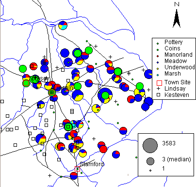
Figure 13: Comparative distribution map of pottery, sculpture, coins and manorial lands in Lincolnshire
Select to open interactive map in a new window (requires Java)
Comparison with Domesday figures provides an interesting correlation between those settlements with substantial holdings at Domesday and those associated with high amounts of pottery (Figure 13). Most of the places with large concentrations of pottery are also associated with large Domesday landholdings. While it can be perilous to argue the importance, or even existence, of settlements during the 10th century from documentation in the 11th, it would be folly to ignore the wealth of information that Domesday presents. Certainly the correlation between large-scale pottery consumption and important manorial holdings differs from the distribution of coinage, which hugs the Roman road system (Foster and Longley 1924; Blackburn et al 1983; Early Medieval Corpus of Coin Finds). Interestingly, it also differs from the distribution of stone sculpture associated with the emergence of the parish church and the patronage of wealthy landowners (Everson and Stocker 1999, 82-6).
While many settlements with high levels of pottery consumption are associated with large-scale landholding, not all important manorial settlements are associated with large amounts of pottery. Instead, one must look for another element. The strong connection between the pottery trade and towns suggests that those settlements that held strong ties with the town might also demonstrate large amounts of town products, in this case, pottery. This argument is strengthened by the close proximity of these settlements to roads and rivers, the communication axes of the towns. Indeed, it is reasonable to suggest that settlements along communication routes would hold a stronger association with towns than those which were more inaccessible. This is supported by Blair's observations concerning the roads to Oxford. Three of the main roads leading to Oxford were referred to as 'portway' or 'portstreet' indicating that they were associated with movement to the town and market (Blair 1994, 121 & 154).
The time-distance distributions along the roads sheds further light on this question, especially the map of Lincoln wares. Many of the sites with large amounts of pottery are approximately one day's travel from the kiln site by ox and cart. Indeed, while pottery is found extensively throughout Lincolnshire, few large concentrations of pottery exist further than a long day's travel. This has interesting implications for town-hinterland relations. It suggests more frequent trade between town and hinterland within a day's travel along the roadways, although the distribution of coins does not support this. However, the pottery and coinage distributions may indicate two different levels of commerce. Medieval pottery has never been associated with high status trade (Moorhouse 1978, 14). A more comprehensive study of all artefact types would be needed to understand this pattern further.
Nevertheless, connections between manorial settlement and town can be seen in documents that list a town property associated with a manor (Hinton 1977, 75-6; Blair 1994, 117-19 & 155-9). Analysis of the Domesday records for Oxfordshire indicates that there were a substantial number of townhouses in Oxford, Wallingford, Cricklade and Winchcombe, which were attached to manors in the surrounding countryside during the late Anglo-Saxon period. These manors did not owe geld to the towns but instead held the obligation of providing maintenance to the town walls (Blair 1994, 117-19 & 155-9). Strong social connections between town and manor might well be reflected in the material record. Economic models for the distribution of pottery have highlighted a number of trading scenarios, namely
However, elevated trade between townhouse and manor, facilitated by personnel from the manorial household or lands, has not been discussed. While more research would need to be done to support this hypothesis, it may be that those manors which demonstrate a high amount of pottery are those manors which held town-houses within Lincoln. Furthermore, it would be advantageous for the 'town-house manors' to be within a day's travel of Lincoln in order to manage estates and participate in the growing political arena of the town.
This article has investigated an approach to examining social practice within a regional landscape using artefact distributions. Many of the successful integrations of social theory and landscape studies have resulted from the employment of view-shed analyses and landscape modelling. It is less clear how artefact distributions can be used to discuss landscape and social practice. This article has offered one such approach, which focuses on examining the travel time between the place of production and the place of consumption along Roman roads and rivers. Instead of employing artificial Euclidean distances to examine distribution patterns, socially meaningful measurements were used in regression analyses and in map generation. Approximations of distance based on road and river routes, as well as the estimations of the time it took to travel along those routes via transportation options available during the early medieval period, were used to analyse the pottery distribution in Lincolnshire. This approach has raised a number of questions concerning the articulation of the pottery trade between the rural and urban populace of late Anglo-Saxon England. While we cannot walk in the footsteps of past peoples, we can hope to travel beneath the crows, coming closer to the social practices of the people we study.
![]()
![]()
![]()
![]()
© Internet Archaeology
URL: http://intarch.ac.uk/journal/issue13/1/6.html
Last updated: Wed Nov 13 2002