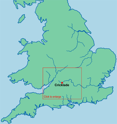
Cricklade is situated in North Wiltshire (Figure 1), at what has in the past been the highest point of navigation on the Thames. It lies very close to the crossing of the Thames by Roman Ermin Street, which runs from Gloucester and Cirencester in the north-west in very nearly a straight line south-east to Wanborough near Swindon, and then to Mildenhall near Marlborough (Figure 2).
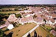
Two sites (Figure 3) were excavated in 1975: Site A, which uncovered a small Roman settlement, and Site B on the Anglo-Saxon defences (Figure 4). A summary report on the Roman Site A is given in Part 1.
The principal interest of Cricklade lies in the fact that the town is one of the most regular examples of the class of Saxon urban fortresses created as part of a fort-system in the late 9th century, which are included in the Burghal Hidage List (Biddle and Hill 1971; Biddle 1976a; Biddle 1976b; Wormald 1982, 152-3; Haslam 1984a, 106-11; Haslam 1986). Its defences are relatively well preserved, and show particularly good evidence of rectilinear planning (Haslam 1986). It has been the subject of detailed archaeological and historical research in the past 55 years (Loyn 1963; Radford 1972), and its defences at least can lay claim to being the most systematically explored of those of any late Saxon fortress in England. A summary of the salient points of its history have been given in Thomson 1961 and Haslam 1984a, 106-11.
In this report the neutral term 'fortress' is used, rather than 'burh', to describe both Cricklade and other fortified sites of the period, following the comments on the matter by Hill and Rumble (1996, 3) - notwithstanding the pertinent comments of Biddle that many of these places (Cricklade amongst them) were not merely fortresses but fortified towns (1976a, 124 and n.197).
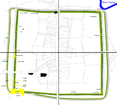
Two large sites were excavated at Cricklade during April-July 1975, prior to housing development. The first (Site A) lay in a field inside the north-west corner of the defences, the second (Site B) in an open paddock on the south-west corner of the Saxon defences themselves (see Figure 3).
The first produced very little material later than the Roman period. However, excavations on Site B have provided a considerable amount of new evidence relating to the structure and layout of the late Saxon defences. This has necessitated a reassessment of the results of the long series of earlier excavations on all four sides of the defences of the burh published by C.A.R. Radford (1972), and is the subject of Part 2 of this article. The archaeological and historical development of the defensive sequence as a whole is examined in Part 3, and the topography and early development of the town is discussed in Part 4.
The main purpose of the excavations on the defences was to examine relatively large areas on the corner and sides of the defences of the fortress on a larger scale than the narrow trenches of earlier excavations, whose primary purpose was the recording of vertical sections. This aim was not, however, fully achieved owing to the almost constant sunshine during the 10 weeks in the field, and to the sudden curtailment of the time originally planned for the excavation. In the circumstances the vertical sections which were drawn were in fact among the most useful of the different types of detailed records made.
The line of the former defences of the Saxon fortress could be identified as a low mound within a grass-covered field. Their course had been defined by trenches (Figure 6) dug both by C.A.R. Radford and F.T. Wainwright and which have been published by Radford (1972, 78-9, but see also Wainwright 1955-6). The bank was further defined by a detailed contour survey of the whole field prior to excavation. Topsoil and subsoil were stripped by machine over three main areas on the line of the defences. Several deeper trenches across the line of the defences on the south and west sides were also excavated by machine both to act as a control for excavation and to locate the ditches. Radford's trench R.V (near the corner) was also partially re-excavated by machine to observe the stratigraphy in this area with as little initial destruction as possible (this is drawn as section 4). Several smaller trenches were subsequently opened to explore individual features. The relationships between the features of different periods were most easily discernible on the southern side of the defences where the depth of survival of the defences was greatest.
 [View help on how to use DWF files]
However, the difficulties caused by the drought meant that only selected areas were completely excavated, and in only one small area in Area 2 was it possible to investigate the pre-bank surface other than in section. Areas and trench numbers are marked on a plan, on which are also marked the numbers of the sections published here. The overall plan of the defences in the south-west corner is also given (Figure 7).
The archaeological data can best be interpreted in terms of six broad periods (0-5), which represent archaeological events both of short duration and long intervals (i.e. processes) between them.
© Internet Archaeology
URL: http://intarch.ac.uk/journal/issue14/1/intro.htm
Last updated: Mon Jul 7 2003