The initial idea was primarily to publish GIF files of the various plans and sections, supplemented by just three DWF (Drawing Web Format) drawings of selected sections and an animated GIF based on an isometric reconstruction of four periods of the Cricklade defences (see Figure 4). The brief given for the work was, therefore, to scan the monochrome permatrace drawings, 'clean' the scans using image editing software such as Adobe Photoshop, and where necessary introduce colour to enhance the drawings and/or aid interpretation. In addition, the three sections to be published as scalable DWF files were to be digitised in AutoCAD.
Given that the Cricklade article was in some respects an experiment, and although some of the drawing formats that were eventually used in the publication were initially unfamiliar, the methodology applied saw something of an evolution as the work progressed.
Four software packages were used in the image production, these being Adobe Photoshop, Adobe ImageReady, AutoCAD and Adobe Illustrator. Figure 2 illustrates the process of the image creation.
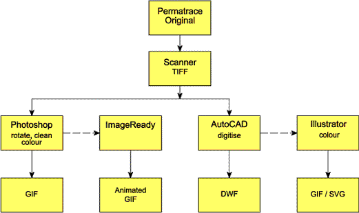
Figure 2: Flow chart of stages of work required to produce images.
As all the images were to be published as GIFs, with some supplementary DWF files, the first requirement was to scan the original drawings. Initially a small selection of the drawings were scanned in sections using A4 and A3 flatbed scanners. However, when the various sections were reassembled it became evident that slight errors had been introduced along one axis, and it was impossible to accurately join one to another. As a result, all the images were subsequently scanned as 200 dpi monochrome TIFF files using a sheet-feed scanner capable of scanning the entire image in one go.
Because Photoshop cannot rotate a bitmap image by arbitrary amounts, the images were converted to greyscale or RGB colour files in order to correct the alignment of the original scans (Figure 3). The images were then cleaned and the resolution reduced to 72 dpi for digital publication. Details such as context number and colour coding to represent phasing were also introduced once the resolution had been reduced. The images were finally saved as GIF files for publication in the article.
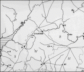
Figure 3a and 3b: Example of the raw, greyscale scan and the final published illustration.
The fact that the original drawings were on permatrace meant they required a considerable degree of editing to remove blemishes, crease marks and the inevitable stray pixels etc. As the work progressed, and many hours had been spent removing these unwanted marks, it became apparent that it would in some cases be quicker and cleaner to digitise the images in AutoCAD and to create GIFs from the digitised images.
A single animated GIF was also required to illustrate the succession of defences. The original drawing comprised four overlapping isometric images of the defences at various points in time (Figure 4).
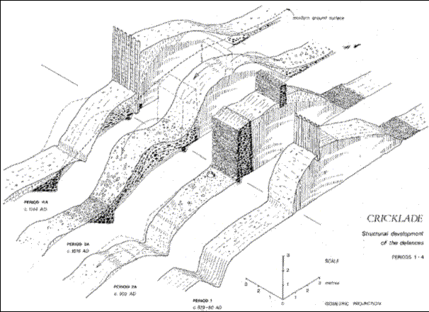
Figure 4: Original isometric drawing which was divided up into 'frames' to create an animated sequence of defences through time. [Compare with the published animation]
Once scanned and cleaned, four new layers were created in the Photoshop document, each to represent one of the four phases illustrated in the drawing. The individual isometric images were then copied to the different layers, and each aligned over the others to provide a common origin. Accurate positioning of the images on each layer was achieved by temporarily making each layer semi-transparent, so that the image below was visible and the image being moved could be manipulated one pixel at a time until a satisfactory overlay was attained. The Photoshop file was then opened using Adobe ImageReady, and the four layers used to produce each of the four frames within in the animated file.
The phase drawings might equally have been published as four separate images, held in separate layers stacked on a web page. Although not available to earlier browsers, and therefore not employed in the Cricklade report, JavaScript could then be used to turn those layers on and off dependant on the reader's actions, creating an interactive representation of the phase drawing.
In order to create the supplementary DWF files, the selected sections were digitised in AutoCAD. This was undertaken by importing the scanned TIFF files into an AutoCAD drawing and digitising on screen, though might equally have been done using a digitising tablet. In order to preserve as much of the hand drawn quality of the originals as possible, hatching was avoided and the original shading digitised. Where applicable, named views were established in the AutoCAD file and the final image exported as a DWF.
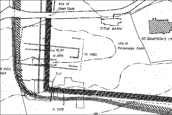
Figure 5: Portion of original scan showing degree of cleaning required.
Some of the images, such as that shown in Figure 5, were fairly intricate and would have required considerable editing in Photoshop to clean them and introduce colour. For this reason it was decided to digitise the originals in AutoCAD and import the vector drawings into Adobe Illustrator to produce the final files. This enabled the application of fill colours to the AutoCAD closed polygons, rather than attempting to clean the shading on the original drawings (see Figure 6).
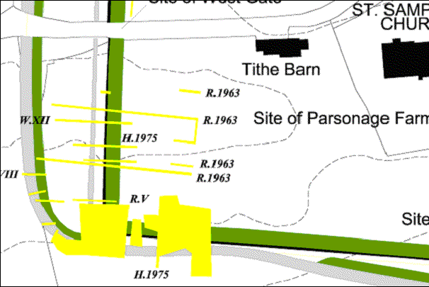
Figure 6: Similar portion of map shown in Figure 5 after digitising in CAD and exporting as a gif from Illustrator.
The images created were all a maximum of 600 pixels in width (to avoid horizontal scrolling for the mahority of readers) and all the images produced can be viewed in the article on the excavations in this issue.
© Internet Archaeology
URL: http://intarch.ac.uk/journal/issue14/5/methodology.html
Last updated: Tue Feb 3 2004