Returning to the study area, how do these concepts help us understand tell settlement, and the locations chosen for the foundation of long-term villages? Does the visual experience from these locations tell us anything about how people rationalised their world and chose to engage with it?
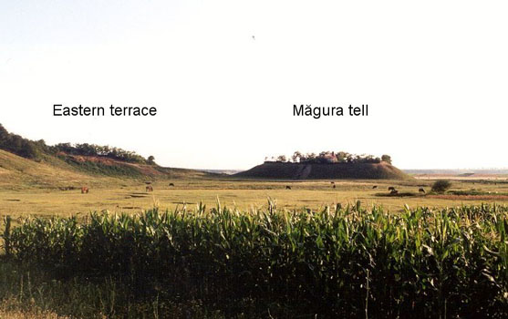
Figure 11: Măgura tell and the eastern terrace, viewed from the north
As we have seen, tells were established at the eastern fringes of floodplains, adjacent to terrace slopes (see Fig. 11). In a way these locations are puzzling. The valley floor locations meant that tells were still subject to annual spring flooding, and occasional catastrophic floods. Also, visibility on a regional level was extremely restricted in extent. A higher location on the edge of the terrace would have protected tells from floods, preserved the proximity to springs, and also would have opened up visual experience to the terrace plateaux which form the majority of the study area. However, I suggest that it is the very nature of visibility within the valleys that influenced people in their settlement choices.
In the period immediately preceding tells, people lived on flat sites out in the open valley floor, on raised, gravelly levees adjacent to formerly active channels. Here people grew cereals on the light, regularly replenished soils, and they moved herds of domesticated cattle and other species across lush meadows at the floodplain periphery. They lived in proximity to marshy palaeochannels with a diverse range of flora and fauna, and in the active channels they harpooned fish and netted crustaceans. Vision from these flat sites achieved good coverage of the valley, and was wholly contained within this topographic zone.
With the transition to tell settlement in the middle of the fifth millennium BC, the apparent shift in settlement form was also marked by a continuity in the ways people engaged with their environments. People continued to herd cattle and grow crops, and there was still emphasis on wild resources. The selection of locations at the valley edge was a conscious decision to maintain a certain way of habitually looking at the world. These allowed continual attendance to the events occurring in the floodplain, which informed on rhythmic changes in the seasons, and also events offering opportunity in the shorter term. This way of looking at the world did not include regular, perhaps inappropriate conception of terrace topography. Although limited in terms of scale, the habitual visibility from the tells provided the majority of practical information people required to go about their daily lives. It was an important aspect of how they had learnt how to engage with the world, and dwell comfortably within it.
Merleau-Ponty has suggested that the perceptual field around a viewer does not represent the experience of seeing out but of being out. He also stressed the indistinguishable relationship between the seeing and the seen, or the sensor and the sensible (Merleau-Ponty 1962). For the people of fifth millennium BC southern Romania, the very experience of being was habitual looking-out to floodplain topography and its periphery. They were essentially a floodplain people, familiar with this environment and identifying themselves with practical roles within it.
© Internet Archaeology
URL: http://intarch.ac.uk/journal/issue16/7/11.html
Last updated: Thur Nov 11 2004