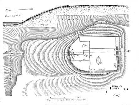
Figure 12: Plan of the Camp du Lizo (Le Rouzic 1933)
Angled passage graves (allées coudées) are later Neolithic (3500–2500 BC) monuments, which occur only in southern Morbihan. Sherratt (1998) observed that the locations in which angled passage graves were constructed had specific topographic characteristics, being on small promontories close to large rivers, a description which is supported by statistical analysis (Roughley 2002a). He suggested that the reason for their location was the control of trade through the area, in particular, Grand Pressigny flint from the Loire to the interior and Dolerite axes from the axe factory at Plussulien to the coast.
Sherratt also suggested that Neolithic settlement sites were associated with angled passage graves not just at the Camp du Lizo (Fig. 12), but also around another angled passage grave at Mané Roullarde. At the Camp du Lizo, there is the most substantial Neolithic settlement in the area, with extensive walls, and in which a large amount of Neolithic pottery was discovered (Le Rouzic 1933). The angled passage grave is situated inside the enclosure.
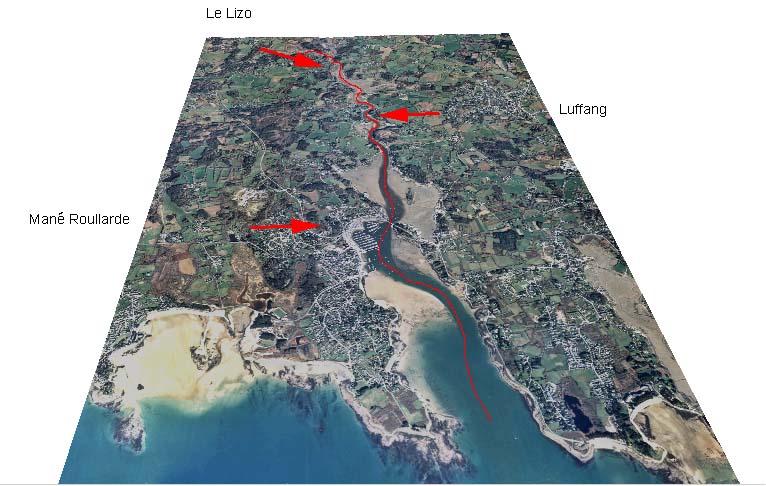
On the Crac'h river, there are three angled passage graves (Le Lizo, Luffang, and Mané Roullarde). Elsewhere, there are two sites on the Auray river (Kerentrec'h and Le Rocher), and another on the Etel (Mane er Hloh). Les Pierres Plates is situated on the end of the Locmaraiquer peninsula. Mané Roullarde and Luffang were visited during fieldwork, and their locations identified on the orthophoto. The Camp du Lizo is currently under private ownership (it was the subject of excavation following damage by the proprietor; Lecerf 1986), with extensive tree cover. 3-D visualisation of the orthophoto coverage draped onto the terrain model clearly shows the extent of the enclosure (Figure 15), and excavation reports help identify the location of the angled passage grave (Le Rouzic 1933; Lecerf 1986).
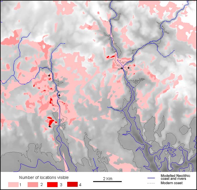
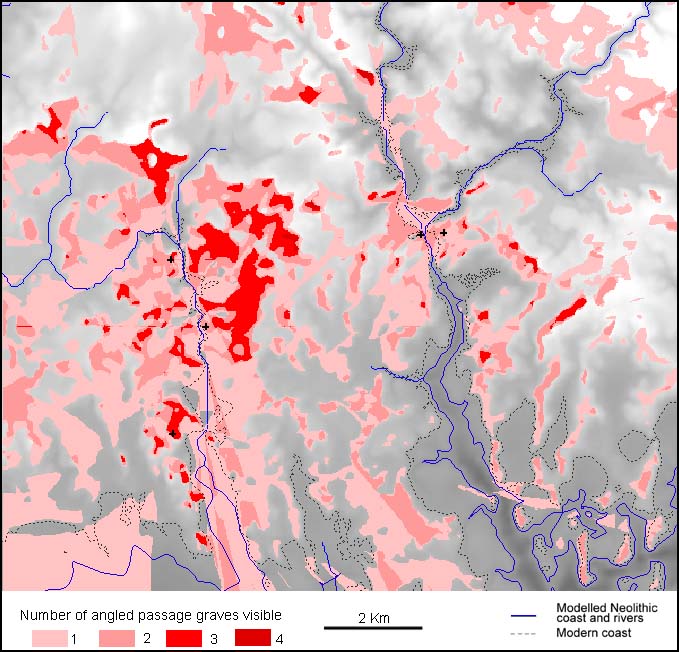
Initial visibility maps suggest that the locations of the angled passage graves were not visible from much of the lengths of the major rivers. Figure 13 shows the viewsheds for the monuments on the Crac'h and Auray rivers. This analysis would imply that Sherratt's proposition that these monuments were located to communicate with people travelling along the river was implausible.
However, the precise height of the original monument would have had a large effect on the visibility of it. The monuments are located on convex promontories, the slopes of which tend to obstruct views of the site locations. If all sites had as large a mound as Le Rocher (an unpublished plan by Rev. W.C. Lukis shows it to have been over 4 metres high in 1868; Sherratt and Roughley forthcoming), then the monuments could have been seen from the river (Fig. 14). Minor topographic changes (including the precise height of the river in the Neolithic) would also have been critical to the visibility of these monuments.
Landscapes were not experienced from a static perspective; people engaged with monuments as they moved within and through the landscape. Visualisation provides the ability to place an observer within the landscape. It is possible to begin to appreciate how monuments were encountered within the landscape.
To investigate further the view of the angled passage graves obtained while travelling up the Crac'h river, a dynamic visualisation was created. The orthophoto coverage was draped over a terrain model, and the sites are represented by red domes, which have 4m radii, to ensure that they are as easily perceived as plausible from available data. The route for the visualisation is shown in Figure 15.
Figure 15b: Dynamic visualisation of the route travelling up the Crac'h river.[File as AVI zip download]
The angled passage graves of Mané Roullarde and Luffang can be clearly perceived on the horizon as the observer moves up the valley. However, Le Lizo is harder to distinguish, until the observer returns towards the site from inland. The enclosure, however, is much more easily seen. This is not just because of its larger size, but also because the convex slope obscures the angled passage grave when the observer is close to it, even when modelled at 4m high. If other monuments are included in the visualisation, a contrast becomes apparent between obscuration of the angled passage grave, and the clear views of other monuments on the river banks (Fig. 16).
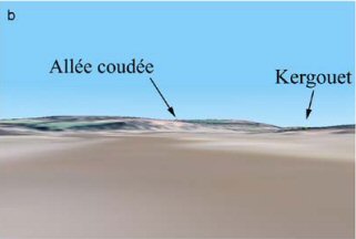
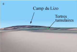
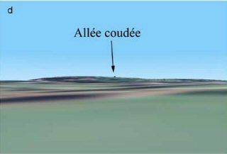
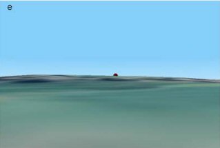
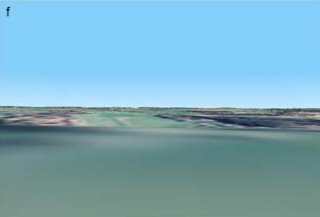
Figure 16. Frames from dynamic visualisation of Le Lizo – a. View north towards Camp du Lizo; b. View north along the Crac'h river towards the enclosure. The allée coudée possibly visible, whereas the dolmen of Kergouët is clearly seen; c. View south towards Le Lizo, the allée coudée is hidden whilst the enclosure and tertres tumulaires are clearly visible; d. From inland, the allée coudée is visible on the horizon; e. The allée coudée remains clearly visible at closer range; f. View east from the allée coudée
The dynamic visualisation examined views obtained whilst travelling up the Crac'h river, and then approaching Le Lizo from inland. This is just one possible journey through this landscape, aimed at examining the relationships between the monuments and the river. The landscape contexts of the angled passage graves can be explored further by you, the reader, using the VRML version of the landscape.
The following examples show how you can use this to explore the landscape further:
Figure 17: View from Luffang, looking towards Camp de Lizo (centre left). The angled passage grave is just visible, whilst the enclosure is clearly seen

Figure 19: View south from the estuary, Mané Roullarde is clearly visible. However, there are other promontories which would provide a similar effect from this particular location

Important similarities in the locations of many of the angled passage graves were noticed by Sherratt (1998). However, it appears that these locations are complex places. Locations which are not particularly visible from the rivers may have been made noticeable through the construction of large monuments. Nevertheless, the angled passage graves are not always the most obvious structures, with other monuments more easily seen from the river. Visibility analysis at Le Lizo suggests that there are other locations on the same hilltop which are more visible from the river. The dynamic visualisation shows that the angled passage grave was more noticeable from the basin than from the river. Of the angled passage graves, Le Lizo has the least pronounced bend in the passage. The chronology of the monuments is uncertain. However, angled passage graves are assumed to have been developed from simple passage graves, and it is possible (though potentially unsubstantiable) that Le Lizo is an early example, and its location was chosen to maintain links with earlier sites in the Coëtatouz basin.
© Internet Archaeology
Last updated: Thur Nov 11 2004