Our fieldwork and the resulting hypothesis regarding the line of the Roman wall circuit, together with the results from the recent excavations and other field observations within the now well-delimited town area, give us a clearer image of the main characteristics of the urbanisation of Ammaia (Fig. 13). Although the ancient site is for the most part unexcavated, and the on-going digs and study of archaeological materials will have to generate more data to understand the chronology of this urban development, we can already distinguish and infer the main layout of this urban site during the Early Empire. It must be remembered that Ammaia, unlike some other towns in Lusitania and nearby Baetica (See e.g. Alarcão 1988a and 1988b; Gorges and Rodriguez Martin 1999; Fear 1996), was probably a virtual greenfield site as no signs of pre-Roman presence were encountered in the four excavated sectors so far. Consequently we can assume that it was built by, or under guidance of, Roman architects, and so would have taken on a Roman guise almost automatically. Ammaia was a new site, and so could be constructed to a standard Roman plan.
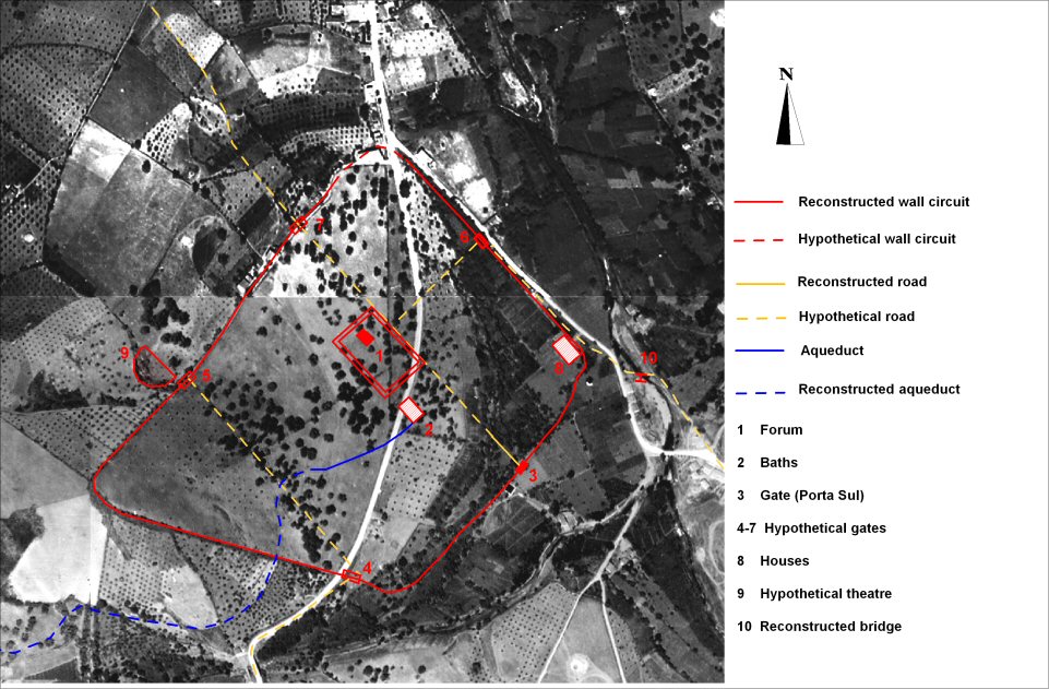
Figure 13: New archaeological scheme of Ammaia (transposed on the aerial photography) as based on our new field observations and earlier fieldwork. [View static image]
Its 1810m-long walled enclosure was certainly interrupted by several gates, possibly as few as five, and reinforced by an unknown number of towers, of which we might have located only two with some certainty (Fig. 13). The precise location of the gates can be mapped with some confidence: they are the well-preserved 'porta sul', the presumed gate at the centre of the north-eastern city side and a gate near-centrally placed in the north-western city side. All of them are no doubt connected with the main street axes of the town: the cardo maximus and the decumanus maximus. The first was partly excavated near the monumental 'porta sul', a gateway possibly on the road to the provincial capital Merida (Carvalho 2003, 76-77). This cardo divides here into two equal and symmetrical halves a porticoed square made of fine granite, and continues in the direction of the heart of the city, the forum. The monumental planned forum complex, possibly of Flavian date, is a rectangular NW-SE oriented square c.95×70m (just a little too square to fit the Vitruvian ideal proportions of 3:2. Vitr., V, I, 2), limited on the north-east by this parallel cardo maximus. It is built partly on an artificial terrace, flanked on three sides by a porticus (or cryptoporticus). On its remaining south-eastern side the forum is probably delimited by a monumental basilica, while its north-western half contained a centrally placed temple, of which a high podium is the well-preserved relic. South of this grand complex a thermal installation, topographically connected to the forum, was partly excavated in the 1990s (Fig. 20).
The cardo maximus no doubt continued its SE-NW trace in the direction of the north-western city side, where it connected to another gate. Aerial photographs of 1952 clearly show its direct relation with the line of a Roman road leaving the city in that same direction (Carvalho 2003, 75-76, photo 2). From the gate which we were able to locate in the centre of the north-eastern city wall, the presumed decumanus maximus probably reached the forum area just south of the main city temple. Its continuation further upslope, beyond the forum, is not proven.
Although a strictly gridded street pattern was not as essential to the classical city as has often been assumed, the evidence we have from Ammaia appears to suggest a quite regular layout for most parts of the urban area, probably with the exception of the steep western extension. There is not only the strict organisation of the town with a quite rectilinear circuit wall, a planned regular forum and two main road axes, but elements in the present-day morphology of the slope, on which the town developed, also suggest this further regularity of the original city plan. Probably already in Early Imperial times the city houses and public buildings were erected on top of a system of north-west/south-east orientated man-made terraces, some of which were arranged as streets parallel with the main cardo and thus exactly perpendicular to the slope. At the surface of the agricultural land covering the area west of the forum today, several traces of such an ancient terrace system can still be seen. It is altogether too early, however, to suggest a modular system, based on the actus, for the layout of such a terraced street network.
Post-Roman degradation of this terrace system, coupled with the gradual abandonment of the inhabited area, no doubt explains many of the erosion processes that occurred in this central and western part of Ammaia. Our fieldwork in the sector of the footslope immediately west of the newly proposed city area showed the existence of many breaches in the actual terrace walling. A first appreciation of the nature of soil material in this sector, together with clear indications for a finely stratified colluvium of similar soil material in the sections of the porticus excavations on the forum, indicate that the source of this colluvium should be sought in this intra and immediate extra muros hilly area of the site. Heavy degradation of culture terraces in the upper part of the walled town and immediately west of this sector could therefore be responsible for most of the post-Roman colluvium cover of the forum area and of other areas of town situated to the east of it. Further detailed evaluation of these excavated sections, together with an assessment of the archaeological finds in the fills, will allow these events to be precisely dated, which could be during different phases of Roman and post-Roman occupation and land use.
Finally, there remains the question of the Roman use of the immediate extra-mural areas of the city. A recent study of aerial photographs and historical documents (Carvalho 2003), as well as some old discoveries of archaeological material interpreted as grave goods (Note 8), all point to the presence of several roads, bridges and some not yet well located Roman cemeteries. Excavation work and more detailed survey will be necessary to clarify these matters further and to map the funerary areas with some precision. Furthermore, there are indications that the sector immediately north-west of the now delimited urban area contained one or even two monumental building complexes designed to present public performances. One semi-circular area, partly hollowed out of the slope near the western extremity of the city (Fig. 13), might well be interpreted as the location of an ancient theatre. Its seating area was then built into the hillside to save material and at least part of the seating could have been made of wood, a fact not uncommon in the Iberian context – the location of theatres and especially amphitheatres outside the city walls is another common phenomenon in Roman Spain and Portugal (Fear 1996). From a geomorphological point of view, this site lies at the head of the small palaeo-valley which delimits the inhabitable and sloping town area to the north-west (see above). The semi-circle, now obliterated by thick woodland, is delimited on the valley side by a low earthwork, containing many pieces of granite. This could be the remains of an original scene building, now obstructing the normal colluviation process in this area.
We could find less direct evidence to indicate the possible presence of an amphitheatre constructed immediately downslope of this theatre site (as suggested by a large oval zone of crop marks on the vertical aerial photographs). Its location, almost centrally in the palaeo-valley, seems very unlikely from the point of view of stability (Note 9).
© Internet Archaeology/Author(s)
University of York legal statements | Terms and Conditions
| Last updated: Mon Nov 21 2005