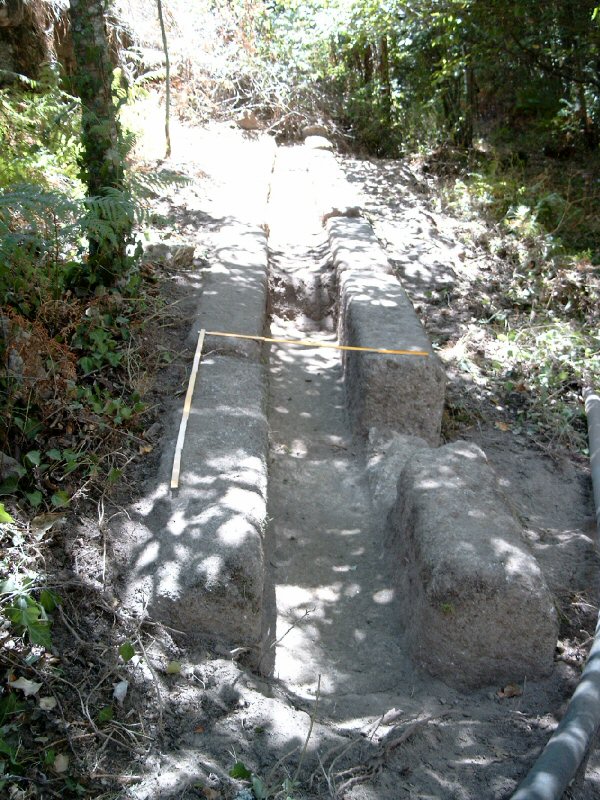
Figure 15: The Roman specus of the western aqueduct discovered in 2004
To reach the upper parts of the city the Romans had to collect and derive water from the hilly area west and south-west of Ammaia. This is a general area of numerous and abundant springs and of the formation of several small water courses giving rise to small ponds.
Geologically (Fig. 4), the area is dominated by orthogneisses, schists, dolomites, alluvial deposits, slope deposits and quartzites. The latter are very resistant to erosion and hence result in high ridges. Where rivers cut across these rocks, they form steeper, narrower, valleys than in the surrounding orthogneisses or schists, because it is more difficult for water to erode these valleys. So, the difference in prevailing rock types and hence the difference in erodibility of the rivers in the area, results in different valley types. The varied lithology can further result in the origination of spring levels, which occur when relatively permeable rocks (e.g. fractured dolomites, unconsolidated deposits) overlay relatively impermeable rocks (e.g. schists). In places where their contact outcrops, spring levels can occur.
During our fieldwork in this area we were able to locate several of these springs, but most seemed to be locally used only and it remains unclear to what extent the Roman town inhabitants made use of them. One such spring lies at c. 1km south-west of the ancient city wall, near Quinta do Padre Francisco (Fig. 3). In fact this 'spring' is more accurately a capture point at the head of a small valley. Its present surrounding vegetation implies that there is a continuous flow the whole year round, certainly a valid argument for the Romans. The capacity of the flow seems, however, quite small and if an attempt is made to reach the upper parts of the city from here, it would involve following a more than 1km-long line along the flanks of the hill, with a supposed crossing of a narrow valley near the actual Ponte da Madalena. Another example was found near the Luisa Manuela farm, just south of the most south-western edge of the Roman town. Water coming from the western hills filters through a layer of sand and pebbles to the surface and forms a kind of small lacus. This low-lying capture point could have been used in antiquity as a local water resource for inhabitants of the western part of town.
Our geo-archaeological reasoning suggested that we should not only look for springs, whose location often implied that the Romans had to cross a river and, therefore, spend much on costly infrastructure to reach their town, as is the case with the spring near Quinta do Padre Francisco. The Romans preferered not to expend undue effort (see Section 6), implying in this case that they would try to avoid building an expensive bridge over a steep and rocky valley in order to reach the town. It is more likely that they would look for a constant water source, which they could easily divert partly to town. For this the creation of an artificial lake would be unnecessary, but instead a series of piled up blocks along the route of a rivulet can be sufficient, as can be seen today in some parts of the Mahgreb in Morocco (De Meulemeester, pers. comm.).
The most likely source of water for collection the whole year through, with high capacity and with distribution to the upper parts of town and the forum area, was seen in the small tributary of the Rio Sever which joins this river coming from the west (left bank) near 'Olhos de Agua'. During an intense fieldwalking effort in the summer of 2004 we were finally able to locate the Roman point of capture at some 550m east of Carvalhal, just north of the road from S. Salvador da Aramenha to Ribeirinha, on the southern flank of Malhadais hill (further referred to as the Malhadais capture) (Fig. 14). This place, recognised in a narrow passage of the steep and rocky valley, diverting a small stream of water from the mainstream of the river, is still in use today for the local water supply. Several intensive cuttings in the granitic bedrock suggest the presence of a now lost small river dam. Along the left bank of this rivulet, some 65m downstream, a narrow gully (0.20 to 0.60m wide and max. 0.40m deep) was clearly cut into the steep rocky valley flanks. Some 25m further downstream the gully passes into a classical Roman type specus, found here by us in situ. A series of connected U-shaped monolithic blocks, with an average length around 1.5m and an internal gully of some 0.38m wide and 0.32m deep, were set in a neat rectilinear construction, just above the winter bed of the rivulet. This construction, now completely hidden by intense vegetation, was partly cleared and mapped over a distance of several metres, freeing at least seven monolithic blocks (Figs 15, 16 and 17). The examined part of the specus lies some 5m north of the present-day rivulet, and some 2.3m higher than the river bed. Its absolute height is 570m, or some 45m higher than the base mark near the most easterly part of Ammaia, the area in front of the museum at Quinta do Deão.
Figure 15: The Roman specus of the western aqueduct discovered in 2004
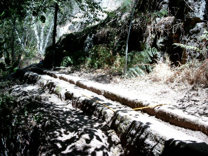
Figure 16: The Roman specus of the western aqueduct discovered in 2004 – detail
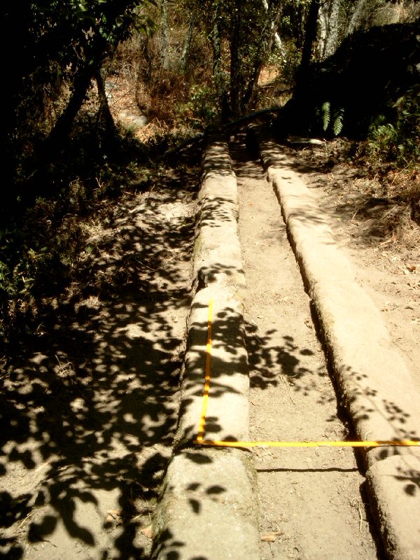
Figure 17: The Roman specus of the western aqueduct discovered in 2004 – detail
Further mapping of its path remains necessary, but it is now already clear that this aqueduct neatly follows the left bank of this tributary of the Rio Sever, passing immediately above the Ponte da Madalena to reach the higher parts of the town of Ammaia near its most southern corner (Fig. 3). Once inside the walled city area, probably after passing a not yet discovered castellum aquae in this area, the aqueduct can be linked to a granite specus (with schist cover stones) of exactly the same type, which was by chance, found in situ west of the forum area some years ago (Figs 18 and 19) (dimensions: length 0.93m, width 0.59m, height 0.48m; Borges 2003, 93, photo 4). The south-west/north-east orientation of the latter points to the location of our newly traced aqueduct and at the same time suggests the general direction of the forum baths as its final destination. The estimated distance of the western aqueduct, as we like to call it, from its spring to the entrance into town, covers some 0.76km. The last part intra muros, until the forum baths, is nearly 0.3km long. It descends some 30m from its source at +570m altitude to the town baths at some +540m above sea level (Fig. 20). In addition to supplying the (public?) baths, as is often the case in Iberian towns, this aqueduct could also supply the upper parts of the town area with fresh water.
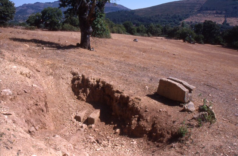
Figure 18: Remains of the specus of the western aqueduct found in the western part of the Roman town area. At a depth of 1m the canalisation was found in situ
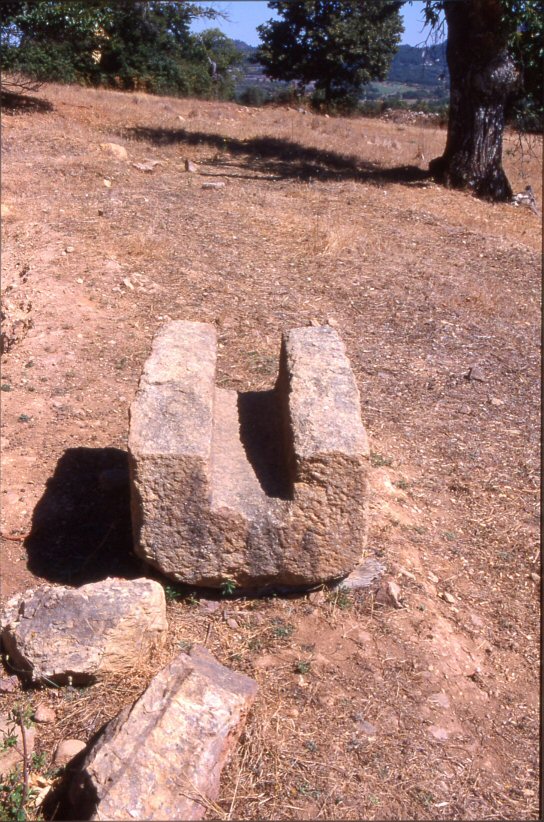
Figure 19: Extracted remains of the specus of the western aqueduct found in the western part of the Roman town area
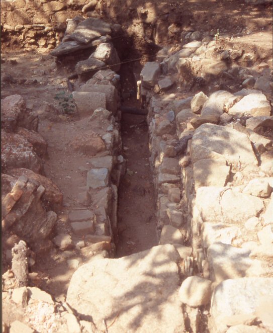
Figure 20: Canalisation excavated in the baths of the forum of Ammaia
© Internet Archaeology/Author(s)
University of York legal statements | Terms and Conditions
| Last updated: Mon Nov 21 2005