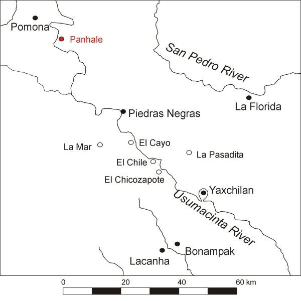
Figure 1: The western Maya lowlands
Figure 1: The western Maya lowlands
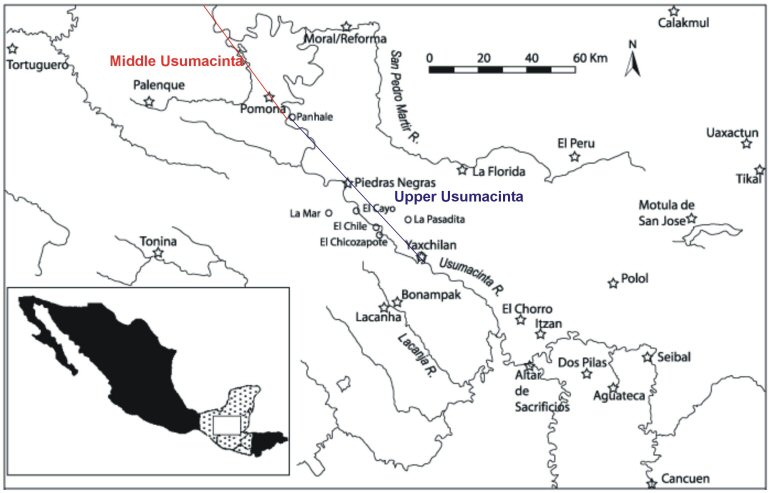
The study area lies within the Usumacinta River region; the Usumacinta River marks the boundary between present day Mexico and Guatemala. This river was, during the Classic Maya period (AD 350-900), one of the most important access routes to and from the coastal plains to the north-eastern Peten. The Usumacinta crosses two distinctive physiographic regions within the study area, the Upper and Middle Usumacinta. These regions control the nature of the river's course and had a significant impact on water transport. The Upper Usumacinta region begins approximately at the Yaxchilán oxbow (Fig. 1), and ends at the locality known as Boca del Cerro (Aliphat Fernández 1994). This region is characterised by hilly karstic terrain covered by a dense tropical forest. In this region the river passes through numerous gorges with steep escarpments (Fig. 2). Aside from these, there are also a series of rapids, five in total, of varying difficulty. The Middle Usumacinta, starts at the point where the river leaves the last stretch of limestone hills at Boca del Cerro, and begins a more sluggish route into the coastal plain of Tabasco (Fig. 3).
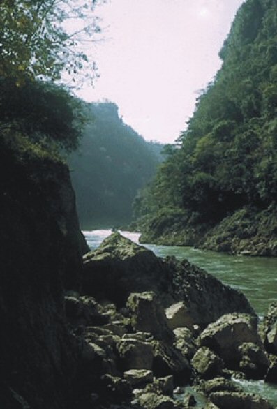
Figure 2: View of the Upper Usumacinta landscape from Piedras Negras
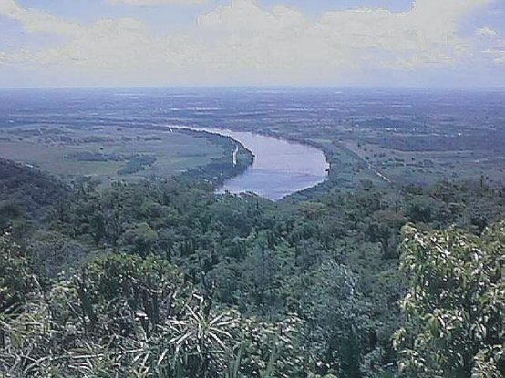
Figure 3: View of the Middle Usumacinta landscape from the Panhalé/Boca del Cerro
This region was the stage on which an intense interaction between the rulers of the different kingdoms of the Classic Maya Period took place. This interaction took the form of royal marriages, political alliances, and warfare, the latter reaching endemic proportions towards the Late Classic (AD 600-900). Although these kingdoms remained autonomous through time, Grube and Martin (1998) have identified in the hieroglyphic inscriptions that a relationship of political subordination could be present between these kingdoms in the context of the hegemonic struggle that ensued throughout the Classic involving the two superpowers of the period: Tikal and Calakmul.
The political organisation of these Classic Maya kingdoms has been approached by various scholars (Adams 1981; Adams and Jones 1981; Ball and Taschek 1991; Flannery 1972; Freidel 1981; Hammond 1974; Hammond 1981; Inomata and Aoyama 1996; Mathews 1988 and 1991; Sanders 1981) most of whom have based their models on a hierarchical ordering of big centres that extended control not only over their immediate sustaining area, but over larger areas that included several lesser centres (Willey 1981, 402). However just a few of these models have made attempts to define the territorial extent of these polities, either through the use of the organisational principles of Central Place Theory (Flannery 1972; Inomata and Aoyama 1996; Marcus 1973 and 1976), Thiessen polygons (Hammond 1974; Mathews 1988 and 1991), or Nearest Neighbour Analysis (Adams and Jones 1981; Hammond 1974).
Central Place Theory is perhaps the most widely used approach in settlement pattern studies. However, Central Place Theory regards centres as having equal political status, despite acknowledging the existence of a rank-order between them (Hammond 1974, 318). Marcus' model (1976) attempted to solve this problem by taking into account the presence of a specific type of hieroglyph, the so-called 'emblem glyph' as a parameter to establish site hierarchy. In essence, the emblem glyph constitutes a sort of heraldic coat of arms that represents the ruling house of a particular centre (Berlin 1958): 'Capitals mention each other's emblem glyphs, but not those of secondary centres; secondary centres mention their capital, but not tertiary centres; tertiary centres mention their secondary centres, but do not mention the quaternary centres, and so on down the hierarchy' (Marcus 1976, 24). Critics of Central Place models argue that the main limitation to the use of these in archaeology lies in the very nature of their conception, that Central Place Theory was originally proposed to address economic issues within a market economy (but for a counter argument see Inomata and Aoyama 1996).
Thiessen polygons are obtained by drawing perpendicular lines half way between major centres; the polygons thus created define the areas that could be efficiently covered by the centres. But, like traditional Central Place models, Thiessen polygons' most important limitation lies in the fact that these polygons give equal weight to centres of different size, hence larger centres will not appear with a larger service area (Hodder and Orton 1976, 59-60).
Hammond (1974) pointed out that at first glance a non-uniform distribution of major centres was apparent in the Maya Lowlands, where the distances between these ranged from 30km around the Maya Mountains, to approximately 20km in the southern Peten and southern Campeche, to 10km or less in the north-eastern Peten, where a clear core area became apparent. Hammond argues that this pattern is non-random and by applying a Nearest Neighbour Analysis he proposed the presence of three distinctive regions where a trend towards shorter nearest neighbour distances in the core area becomes apparent (Hammond 1974, 322-26).
As in the case of Central Place models, Hammond's is equally flawed; the absence of differential weighting between centres. Adams and Jones (1981), aware of this flaw, proposed that along with the spatial patterning of the centres, a rank-size rule based on courtyard count and volumetric assessment should be used to assign site hierarchies objectively, obtaining a four-tiered scheme that, according to the authors, reflect the political, economic and demographic hierarchies between centres (Adams and Jones 1981, 302-07).
Despite the efforts to overcome the limitations inherent in the above-mentioned approaches, the end result is a static map that doesn't lends itself to an interpretation of the more fluid geopolitical processes that were taking place in the Maya Lowlands. From my perspective three shortcomings become apparent in these models.
If we have learned something from the hieroglyphic record about these Classic Maya kingdoms it is that political alliances changed constantly through time. The waxing and waning of these polities resulted in an ever-changing geopolitical map. I propose that to approach these changes better, we have to give a centre's subsidiary sites a more active role in the configuration of the territorial extent of these polities.
In his doctoral dissertation, Aliphat Fernández concluded that for the Upper Usumacinta region, site location and the definition of boundaries between socio-political systems were aspects intrinsically related to the physical landscape (Aliphat Fernández 1994), while Hammond (1975) identified that the interaction of two factors influenced settlement location; these are the tactical and the strategic factors. The tactical factors are those local and environmental factors which influence the decision to establish a settlement, such as access to natural resources (e.g. good agricultural soils, water, flint or obsidian, etc.). The strategic factors on the other hand, are extra-local, and are linked to the relationships between settlements and, as I will argue here, they played an important role in the establishment and definition of the centre's territorial extent. Although at a later date Hammond (1991) stated that boundary maintenance and territorial integrity were unimportant issues to the Maya ruler (Hammond 1991), I maintain that the location of the subsidiary sites, and the attention given to these local rulers by their overlords, are an indication that indeed the territorial integrity of their polities and the maintenance of their boundaries constituted a high priority for the Maya kings.

Figure 4: Location of La Pasadita
These subsidiary sites were the seats of a secondary yet important echelon of the Late Classic Maya nobility, the sahal. La Pasadita, a subsidiary centre of Yaxchilán, is a prime example of this type of site. La Pasadita is located about 10km inland from the eastern bank of the Usumacinta River (Fig. 4). Mathews (1988) has presented in great detail the information on La Pasadita gathered from the hieroglyphic inscriptions, and this site has been the subject of an archaeological survey by Golden and collaborators (Golden 1998). A couple of inscribed monuments from La Pasadita record important events in the lives of the king of Yaxchilán, Bird Jaguar IV and his vassal lord Tilom. Lintel 2 depicts Bird Jaguar IV, king of Yaxchilán, performing a 'scattering ceremony' assisted by his sahal Tilom (Fig. 5). Another monument, Lintel 1 depicts Tilom presenting a bounded captive to his overlord Bird Jaguar IV. Golden suggested that not only did these monuments served to cement the relationship between the Yaxchilán king and his supporters but, most importantly, they may have helped develop a defensible frontier between Yaxchilán and Piedras Negras, a neighbouring kingdom to the north-east of the latter.
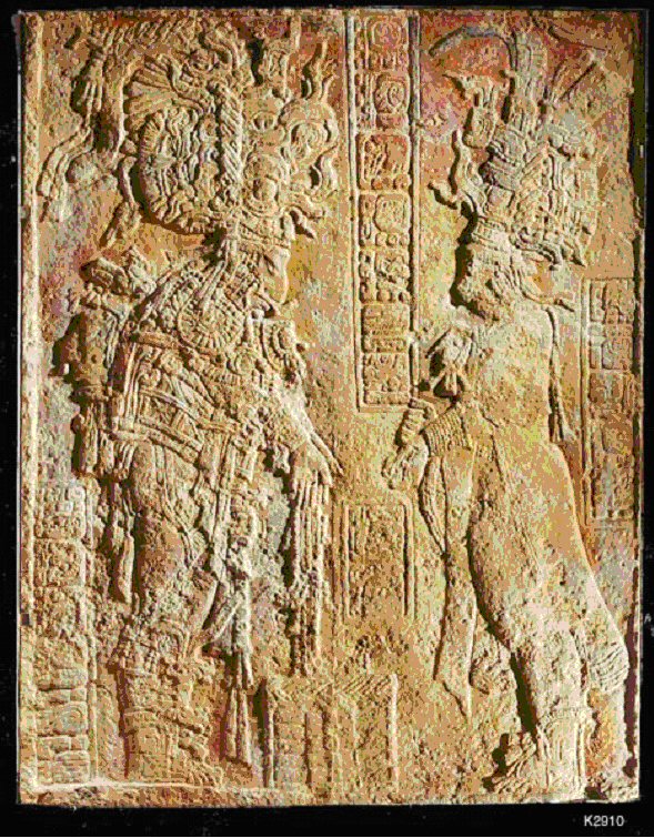
Figure 5: La Pasadita Lintel 2 - Bird Jaguar IV Holy Yaxchilan Lord in a scattering ceremony assisted by his sahal Tilom. Lintel located in Rijksmuseum voor Volkenkunde, Leiden (photograph by Justin Kerr © Justin Kerr, #K2910).
The Upper and Middle Usumacinta region represents an ideal setting for modelling with GIS the vicissitudes involved in moving across the natural terrain. The region is formed by a series of longitudinal valleys separated by steep mountain ranges of up to 600m asl, which represent virtual barriers to movement, except at those points where the presence of faults offer a natural passage (Fig. 6). Likewise, the Usumacinta River is navigable in most of its stretches, except at those points where treacherous rapids force canoe travellers to portage. Given these limitations I argue that access to, and control of, the routes of communication represented a matter of 'national security' in the ambience of endemic warfare that prevailed during the Late Classic, as Mathews describes it (Mathews 1995). From this it follows that those sites located in the vicinity of critical points, such as portages or natural passes in the mountain ranges, must have been deemed strategically important in order to maintain the territorial integrity and also to enlarge the kingdom's domain.

Figure 6: Natural opening marking the entrance to the Redención del Campesino valley
Here, I will examine the relationship between two of these kingdoms: Pomoná, located on the Middle Usumacinta region, and Piedras Negras, located on the Upper Usumacinta. These will be looked at in the light of the available epigraphic data and using GIS as an analytical tool applied to modelling movement across the natural terrain.

Figure 7: Phonetic reading of the Pomoná Emblem Glyph from Pomoná Panel 1
The archaeological site of Pomoná is located on the coastal plains of eastern Tabasco, Mexico. Pomoná or Pak bul as its hieroglyphic name is read (Fig. 7) was, during the Late Classic Maya Period (AD 600-800), the centre of an important kingdom, which occupied a pivotal place in the western Maya Lowlands. Pomoná's importance was not only related to its location near the Usumacinta, but also because it was positioned between the sphere of influence of two great powers of the Classic Maya Period, Calakmul and Palenque, this last one a close ally of Tikal. In effect, the kingdom of Pomoná was situated at a crossroads: it could have potentially controlled movement both across the coastal plain and between the upper and lower stretches of the river. Thus the Pomoná region is an essential one to look at in terms of communication routes up and down river and along the coastal plain. It is perhaps for this reason that this kingdom was so intensely contested by the Palenque kingdom situated to the west of this, and the Piedras Negras kingdom, located to the south. To the north-east, close to the San Pedro Martír River (another important access route to the Peten) is the lesser-known kingdom of Morales/Reforma which, judging by its inscribed monuments, was part of the Calakmul hegemon (S. Guenter pers.comm.).
From the hieroglyphic inscriptions of the region we know that Palenque attacked Pomoná in AD 659 and in 663 (Schele and Grube 1995) and that the powerful influence from this centre was felt again in AD 751. In AD 792 and 794, Pomoná suffered another devastating defeat, this time at the hands of Piedras Negras and its subsidiary site La Mar (Mathews 1995). The strife between Pomoná and Piedras Negras seems to date back at least to the mid-6th century. A reinterpretation of Piedras Negras Stela 12 by Stephen Houston suggests that sometime after AD 554, this centre was sacked by Pomoná and coerced into paying tribute (Houston et al. 2000). This in turn suggests that Pomoná must have, to a degree, exercised control over the territory that was part of Piedras Negras domain.
Panhalé, a subsidiary site of Pomoná and located some 10km to the south-east of it (Fig. 8), could have had a similar function as La Pasadita in the Yaxchilán kingdom, that is, as a site of prime importance in the maintenance of a defensible frontier between Yaxchilán and Piedras Negras. Panhalé acquires particular relevance, since it is found at the very strategic location of Boca del Cerro. Boca del Cerro, as its name suggests, constitutes an opening in the ridges of limestone hills characteristic of the Upper Usumacinta River region; through this opening, the mighty Usumacinta River flows onto the broad alluvial plain on the final part of its journey to the Gulf of Mexico (Fig. 9). Panhalé lies some 100m above the river, close to the summit of a steep, easily defensible hill with commanding views both up and downstream. A carved Late Classic period limestone stela from the site mentions the contemporary ruler of Pomoná, leaving no doubt that at this point in time at least, Panhalé was a part of the Pomoná kingdom (S. Guenter pers.comm.).

Figure 9: View of the Usumacinta river at Bocca del Cerro
© Internet Archaeology/Author(s)
University of York legal statements | Terms and Conditions
| File last updated: Tue Mar 7 2006