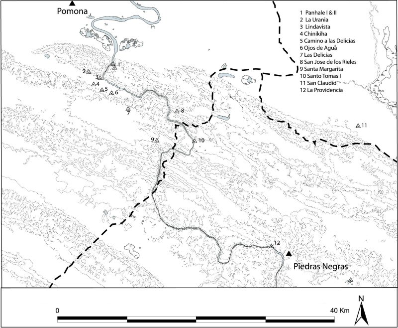
Figure 13: Proposed boundaries between Pomoná and Piedras Negras
Figure 13: Proposed boundaries between Pomoná and Piedras Negras
The boundary between Pomoná and Piedras Negras is presented in Figure 13. In this case in order to define these boundaries more precisely I included the major centre of Morales/Reforma in the estimation of the territorial extent of these two kingdoms. Reforma/Morales, although outside the Usumacinta region, is located on the coastal plains a short distance to the north-east of Pomoná. This inclusion was deemed necessary because of the control that this major centre must have exercised on the traffic coming along the San Pedro Martir River, which was another very important communication route to the north-eastern Peten.
The known subsidiary sites were plotted in the map. All of these are considered sites of secondary importance; they contain monumental masonry structures spread in areas that range from 3 to 5 square km. More importantly, the sites are located at critical points that control passage through the natural openings in the mountain ridges or where portage was necessary to avoid the treacherous rapids that thwart river travel. From the proposed boundary it becomes apparent that Pomoná was in control of all but one of these sites, Santo Tomas I, which falls within the territory of Piedras Negras. Of these I consider that Panhalé was of utmost importance to Pomoná due to its position, a vantage point that dominates the coastal plain and the last stretch of the upper Usumacinta River, and could have easily averted any military incursion, thus it must have been instrumental to this kingdom's territorial integrity (Fig. 14).
The devastating attacks on Pomoná in 792 and 794 mentioned previously that resulted in the capturing of several important sahals, imply the participation of a sizeable force of at least several hundred warriors from Piedras Negras and La Mar. The logistics required in mobilising a contingent this size involved not only securing supplies for the marching forces, but also a route that would conceal to a certain extent the army's movements from military outposts, while providing relative ease of movement.
Hassig's work (1988) on Aztec warfare can help me illustrate this point. He argues that an Aztec army unit of 8000 men marching in double columns would stretch between 12,000m and 6,000m. If the attack on Pomoná involved a combined force of about 2000 men marching in double columns from Piedras Negras and La Mar, then the length of the column could have extended for about 2km. An army this size would have been visible from Panhalé or any of Pomoná's other subsidiary centres located along the river or the mountain passes (Fig. 14).
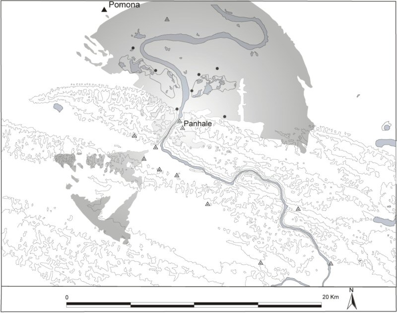
Figure 14: Viewshed from Panhalé
The distance and rate of march is another important aspect to consider. Hassig estimated that the marching rate for the Aztec army unit was between a low of 2.4km per hour to a high of 4km per hour, these figures result in a day's march of 19 to 32km. However, marching over mountainous terrain requires 20% more time (Hassig 1988, 66). The distance between Piedras Negras and Pomoná, and La Mar and Pomoná is about 50km. Considering the characteristics of the terrain, the rate of march would have been at about 2km per hour. At this rate a day's march would have covered around 16km; thus it would have taken the Piedras Negras and La Mar forces about 3 days to reach their objective.
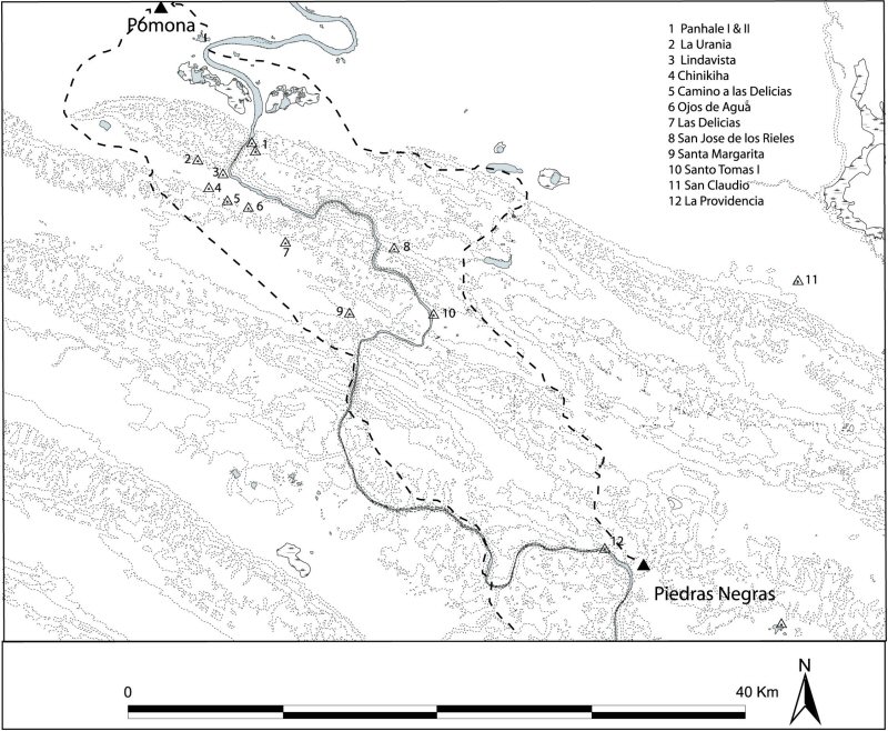
Figure 15: Attack route from Piedras Negras and La Mar
The attack routes were obtained through a least-cost routine and are shown on Figure 15 with three marching possibilities:
Considering the social importance of political hierarchy and the logistics involved in the march of a military contingent of this magnitude, I believe that the third option seems to be the less likely. In the first place it would imply that the Piedras Negras king would begin a major military campaign (which he will use as propaganda in his inscribed monuments) from outside his own capital. The regal ritual protocol, as gleaned from the inscribed monuments, indicates that the vassal lords rallied around their king in this type of campaign. Second and most importantly, the Piedras Negras attack route would provide at least a place of respite at Santo Tomas I, where the attacking forces could regroup prior to their incursion into enemy territory. The second option offers the advantage of presenting two attacking fronts, which would have diverted the Pomoná defences to the La Mar advancing army. In this option the forces marching from Piedras Negras would gain access to the plains through a natural opening on the limestone ridges that is located in the small valley 16km long by 2.5km wide known as Redención del Campesino. At the same time, the contingent marching from La Mar would reach the coastal plain around the tip of the last of the limestone ridges to the west of Panhalé.
A combination of stealth and celerity in the attack must have been necessary to overcome the Pomoná forces. Most importantly, securing a safe passage to the coastal plains must have been of the outmost importance. In this context it must have been imperative that Piedras Negras had control of the natural pass located at Redención del Campesino (note also that valley falls within the proposed territory for Piedras Negras (Fig. 16).
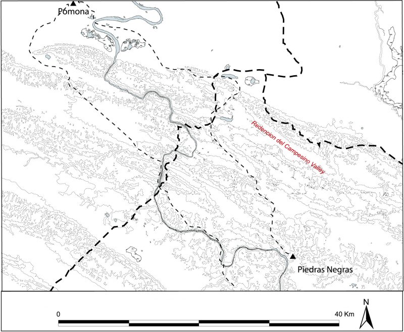
Figure 16: The Redención del Campesino valley
Although there are over 30 sites located within the Redención del Campesino valley, before the Redención del Campesino Archaeological Survey 2003-2004 field season we had no knowledge of the existence of a site of this magnitude in this valley. On this premise, we worked under the hypothesis that the strategic locations of secondary sites (sahal seats) were instrumental to the territorial integrity and boundary maintenance of the Upper Usumacinta kingdoms, thus the survey of the valley was designed to test a site location model derived from Dempster-Shafer Theory.
© Internet Archaeology/Author(s)
University of York legal statements | Terms and Conditions
| File last updated: Tue Mar 7 2006