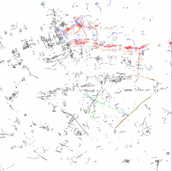
Fig.3 Plot of all known crop marks in the Heslerton Parish Project Area
The present project was established to bring together and analyse a multi-sensor data set including air photographs collected over more than a decade, digital multi-spectral (MSS) data and ground-based geophysics, to extract and interpret the archaeological evidence and establish the contribution that could be made through wider application of MSS data. In addition, it was also important to establish to what extent such a large and complex data set could be easily managed in a GIS environment, incorporating in addition a large body of point data comprising the already established SMR data and any new data derived from recent excavations.
Before any comparison could begin, the various data sets had to assembled, checked and processed. These included a number of photographs that were not yet incorporated into the county Sites and Monuments Record (SMR). The most productive oblique aerial photographs were scanned so that they could be interactively viewed within the Geographic Data Management System (GDMS) and the archaeological features digitised and transformed as vector files. The NERC acquired vertical colour stereoscopic photography and Daedalus 1268 11 band, 2m ground resolution, multi-spectral scanner (MSS) imagery from an altitude of 800m on the 17 and 27 June 1992. The imagery acquired on 17 June was badly affected by low cumulus cloud and its shadow, and was of only limited use. However, data acquired on 27 June were of an excellent quality. Ninety-two of the near vertical high-resolution colour aerial photographs taken by NERC were selected for the archive.
Between 1978 and 1984, the aerial photographic campaign produced over 1600 monochrome photographs with a significant crop-mark component; a smaller number of colour transparencies provided useful lecture material, but did not add significantly to the features identified. The aerial photographic program was intended to run for a decade with regular flights during the most productive crop-mark periods. In reality, the number and timing of the flights were more ad-hoc being restricted by the availability of pilot, plane and funds. However, despite the ad-hoc nature of the exercise, the overall picture that emerged is unlikely have to have been further enhanced by anything less than a massive increase in the amount of flying time. 1984 proved to be very productive indeed, although more often adding detail to known sites rather than identifying entirely new ones.
From the collected results of several years of air photography and a limited number of stray finds, a picture and an interpretation of the developing landscape was established. Following this project we can see that although the essential picture established through the initial air photography programme remains essentially sound, at a more detailed level the information and, therefore the interpretation, was at best patchy. The lack of continuous cover in particular tended to overemphasise the importance of individual sites without establishing more fully their context.
Fig.3 Plot of all known crop marks in the Heslerton Parish Project Area
The prints and negatives from the substantial number of aerial photographs taken by one of the authors between 1978 and 1984 were developed and their positions were established before being entered into the database. A total of 1614 aerial photographs are now archived for inclusion in the county aerial photographic SMR. In conjunction with the archiving process, 191 of the oblique aerial photographs were selected for digitising (most had already been digitised prior to the start of the project). A simple four-point transform was applied and a single view digitised as it was felt that to expend resources trying to generate very high precision plots would restrict our ability to process all the data without any significant benefit; if any site were subsequently to require excavation a more precise plot could then be undertaken. Our concern in the digitising was to establish the relative placing of features rather than very precise placement within any field. A positioning error factor in the region of 5m on the ground was considered acceptable for our purposes; in most cases the error is likely to be less.
In addition, 92 near vertical high-resolution colour aerial photographs taken by the NERC in conjunction with the multi-spectral image have been transformed and digitised (see Figure 3 for a plot of recorded cropmarks).
Analysis of the near vertical aerial photographs collected on 27 June 1992 reveals that the NERC verticals are of outstanding quality and that the timing of the flights coincided with a period of high cropmark visibility. These pictures alone, when put together, provided an unparalleled view of the area by virtue of the high view angle and contiguous cover they provided; clearly in another year or at another time we may have been less fortunate and seen far less. The area covered by the vertical colour photographs is also covered by 714 oblique black-and-white photographs, thus providing an average coverage of 15.7 photographs per sq. km. The high quality and high data content of the large format vertical photographs provide an ideal comparative data set for examination of the synchronously collected multi-spectral imagery.
©
Internet Archaeology
Last updated: Wed Apr 23 1997