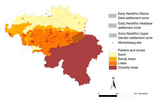
Figure 5: Early and Middle Neolithic site distributions throughout the Scheldt basin (after Crombé and Vanmontfort 2007)
Figure 5: Early and Middle Neolithic site distributions throughout the Scheldt basin (after Crombé and Vanmontfort 2007)
Agriculture arrived in the Scheldt basin around 5300/5200 BC with the colonisation of the hilly loess plateau zone by Linearbandkeramik (LBK) and Groupe de Blicquy populations (Figure 5). Both cultures were confined to specific settlement 'clusters' (Bakels 1982), yet isolated finds of their respective material culture packages can be found across the entire loess region (cf. Jadin and Hauzeur 2003; Hauzeur 2006). The LBK is known from over 200 sites in the Hesbaye region, three in the Kleine Gete valley, and five in the upper Dender area (van Berg and Hauzeur 2001; Jadin 2003). Blicquy settlement, on the other hand, is known from just nine sites in the upper Dender area and two in the Hesbaye region (van Berg and Hauzeur 2001; Hauzeur 2006). LBK and Blicquy populations can be distinguished from each other based on pottery decoration and technology, lithic technology, and by the Blicquy practice of cultivating naked wheat, as well as their general cultural traditions of influence (Hauzeur 2002; van Berg and Cahen 1993). Debates are still ongoing concerning the contemporaneity of LBK and Blicquy populations in middle Belgium, and at the moment the evidence does not throw much light on such a complex issue. However, studies have recently supported Constantin and Ilett's (1998) position on the slightly younger settlements of the Groupe de Blicquy (Allard and Bostyn 2006; Caspar and Burnez-Lanotte 1998; Crombé and Vanmontfort 2007). While far from complete, the current state of evidence does allow for a preliminary assessment of their relative economic and land use strategies.
Besides the domestication of naked wheat by Blicquy groups (Heim and Hauzeur 2002), the economic systems of both LBK and Blicquy populations seem to be the same. The early agricultural economy of the Scheldt basin was based on plant (emmer, einkorn, barley, flax, lentils, peas) and animal (primarily cattle and pig, with less reliance on ovicaprids) husbandry, alongside supplementary hunting, fishing, and gathering practices (Crombé et al. 2005; van Berg and Hauzeur 2001). Jadin (2003) has recently highlighted that the palynological evidence from Darion-'Colia' indicates a mixture of deforested open 'pasture' land and more closed forest areas that were intentially maintained around the immediate settlement. This could have been due to the need for important resource procurement locales around the immediate proximity of the settlement. Futhermore, the Kleine Gete settlements of Wange-'Neerhespenveld' and Overhespen-'Sint Annaveld' have revealed minimal forest disturbance, and a localised landscape of small cleared areas surrounded by vegetation (Lodewijckx and Bakels 2000, 35). Unfortunately the bad preservation conditions of the acidic, well-drained loess soils of the Scheldt basin do not allow anything more than a base-level assessment of Early Neolithic subsistence systems. Generally, the agricultural system of the Linearbandkeramik culture is thought to have been intensive, based on smaller local garden plots, not on shifting swidden agriculture (Bogucki and Grygiel 1993; Bogaard 2004). Due to the intensive nature of cereal cultivation, Bogaard (ibid.) argues for the close correspondence between both plant and animal husbandry, which was necessitated by the need for manuring. If this was the case, pastoralism would have been a less significant aspect of animal husbandry practices in the LBK period. If early agriculture in the Scheldt basin was in fact intensive rather than extensive, this would have had significant implications for land use systems and the production, consumption, and maintenance of cultural landscapes by early agricultural groups.
LBK and Blicquy settlements were located on tertiary plateaux within a dynamic, undulating landscape of hills and river/stream valleys. These sites were based around the availability of water, and some of the most prominent sites (e.g. Darion) were located on the confluence of two streams or rivers. Deep post-holes indicated the construction of substantial longhouses that would have provided one or many households with a habitation for many generations. The primary settlement clusters of the LBK and Blicquy populations remained the same for the entire 500/300 years of their inhabitance of the Scheldt basin. The one exception to this is the LBK settlements in the Kleine Gete region, which seem to be established after the first Hesbaye colonisations, and were inhabited for possibly one, or two generations at the most (Lodewijckx and Bakels 2000). On a general level, isolated scatters of Early Neolithic material culture (cf. Jadin and Hauzeur 2003) suggests that the earliest agriculturalists stuck to the loess regions, and rarely ventured onto the sandy-loamy transition zones or on the sandy lowlands (Crombé and Vanmontfort 2007). A recent survey of isolated finds (adzes, armature danubienne, Ghlin flint, Bartonian flint, worked Schist, débitage d'allure) outside core LBK settlement areas has indicated specific loci of rather heavy activity in northeast Flemish Brabant, western Wallon Brabant and Liège provinces, with the most abundant evidence coming from the Mons region of eastern Hainaut (Jadin and Hauzeur 2003, 82). These data suggest specific 'privileged' (Jadin 2003) loci of LBK activity outside the core habitation zones. Crombé and Vanmontfort (2007, 263-65) suggest that sites such as Kerkhove (Crombé 1985) and Oudenaarde-'Donk' (Parent et al. 1987) represent early agriculturalist (Blicquy) logistical exploitation of a wider environment along the transition zone between the loess and sandy-loamy soils, over 20km from the nearest settlement in the upper Dender.
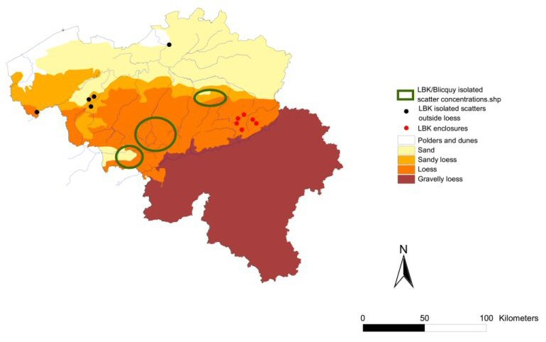
Figure 6: LBK enclosures, significant LBK/Blicquy isolated scatter concentrations, and isolated LBK/Blicquy scatters outside the loess region (after Jadin and Hauzeur 2003)
LBK territoriality is better understood than that of the Blicquy population owing to the cultural landscape dynamics between localised palisade enclosures around settlement zones and the isolated scatters of material culture within specific 'privileged' locales throughout the loess region (Figure 6). Six enclosures (Darion-'Colia', Voroux-Goreux-'Campagne de Fooz', Oleye-'Al Zèpe', Remicourt, Vaux-et-Borset-'Gibour', Waremme-'Longchamps') are located along the western periphery of the upper Geer valley (Bosquet et al. 2004; Jadin 2003). Keeley and Cahen (1989; also Cahen et al. 1987) have argued that these enclosures represent a defensive mechanism against indigenous hunter-gatherer groups, but Jadin (2003, 699) has pointed out that they were probably used for a variety of functions not mutually exclusive for defence purposes. The latter explanation fits better with the rather unusual and ambiguous presence of so many enclosures within such a small region. No matter what their specific function, these enclosures reveal a different partitioning of space than that seen from the broader Neolithic cultural landscapes, as well as the settlement strategies of indigenous hunter-fisher-gatherer populations. At the moment not enough secure evidence exists for connecting these structures with the possible relations between Late/Final Mesolithic groups in the region.
Around 4800 BC the 'Danubian' tradition disappears from the Scheldt basin and is not supplemented by the Rössen (Bischeim) culture as indicated from the northern Rhine and Meuse river valley area (Crombé and Vanmontfort 2007; Crombé et al. 2005; van Berg and Hauzeur 2001). The Scheldt basin is definitely an anomaly when it comes to a linear assessment of the development and spread of agriculture within the regions of northwest Europe. Virtually no evidence of a Neolithic way of life exists in the loess region from 4800-4500/4300 BC, whereas the sandy lowlands attest to the Final Mesolithic Swifterbant culture.
The second manifestation of early agriculture in the Scheldt basin comes from the appearance of the Michelsberg culture in the loess regions around 4300 BC (Vanmontfort 2006; Vermeersch 1990; Vermeersch and Burnez-Lanotte 1998). By 4100/4000 BC this culture reaches the lower Scheldt basin and is found in the same general vicinity of the Final Mesolithic Swifterbant habitations at Doel-'Deurganckdok' (Crombé et al. 2002; 2005; Crombé and Vanmontfort 2007). The Michelsberg culture of the Scheldt basin signals a restructuring of both the economic and social organisational structures known for the LBK period. These effects are indicated by data for more flexible and 'opportunistic' settlement strategies, which reveal a more heterogeneous way of transforming and exploiting cultural landscapes. Sites are known from valley heads, hilltops, Pleistocene terraces and plateaux, and caves or shelters (Vanmontfort 2006; Vermeersch 1987-1988; Vermeersch and Burnez-Lanotte 1998). Enclosures of many kinds become commonplace during this period (Vermeersch 1987-1988), which most likely refers to changing territorial strategies across the entire landscape.
The available paleoeconomic data demonstrate a fully agropastoral economy supplemented by small amounts of hunting and gathering. Faunal data are dominated by domestic cattle, with smaller amounts of pigs and ovicaprids (Gautier and Biondi 1993; Vermeersch 1987-1988). It is presumed that cereals were either grown or imported at most known settlements, while it remains difficult to estimate the relative importance of gathering (Vanmontfort 2006, 110).
Where available, pollen evidence has indicated how these peoples had a rather substantial impact on the natural environment (ibid.). Michelsberg settlement systems are evidenced by a myriad of enclosures, ditches and pits (Vermeersch 1987-1988). These habitations exhibit rather significant variability of settlement types during this period. Furthermore, settlement evidence, or the lack thereof, is indicated by the absence of substantial post-holes that would refer to long-term habitations of specific locales (Vanmontfort 2006). Instead, researchers have highlighted the probable existence of shifting, shorter-term habitations compared to those of the Early Neolithic (Crombé and Vanmontfort 2007; Vanmontfort 2006). Most available data indicate a flexible approach to the cultural landscape, and the importance of periodic (supra-annual) movements throughout the landscape. Vanmontfort (ibid., 115) has recently theorised that inter- and intra-regional interactions between people explains 'both the regional differences and the vague limits between the regionally defined groups'. This hypothesis contributes greatly to interpretations of the middle Neolithic as both an intensification and diversification of the socioecological structures that constituted the contacts and interactions between groups.
© Internet Archaeology URL: http://intarch.ac.uk/journal/issue22/4/3_3.html
Last updated: Wed Oct 3 2007