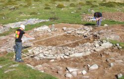
Photo 1: A small upland roundhouse being excavated at Hengwm, Dyffryn Ardudwy, Gwynedd (Johnston and Roberts 2002).
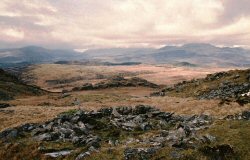
Photo 2: The remains of a stone built roundhouse, Bryn Cader Faner, near Harlech, Gwynedd (photograph: Adrian Chadwick).
This article presents the aims, methods and results of The Welsh Roundhouse Project. The research was funded by The University of Wales Board of Celtic Studies and began in 2004 with the collection of data from all excavated roundhouse settlements in Wales. The project was intended to provide the first comprehensive study of later prehistoric and early historic settlement practices in Wales. It is hoped that it will serve as a resource for researchers and, through the analysis provided in this article and to follow (Ghey et al. in prep.), provide an important counterpoint to similar studies from elsewhere in Britain.
The rationale for the project stemmed from two observations. First, the varied role and architecture of roundhouses in Wales has not been the subject of detailed, systematic analysis. As a result, broad historical and geographical patterns and changes in the definition, function and scale of domestic space have yet to be identified – even if more localised trends have been observed. Second, given the lack of such long-term studies and the perceived impoverishment of the settlement record for Wales (e.g. Haselgrove et al. 2001, 30, table 3), there has been a tension between writing a distinctively Welsh prehistory and a reliance on models of social change and domestic space drawn from elsewhere in Britain.
An inspiration for the project's approach was the long-term and multi-scalar perspective taken by Pope (2003) in her analysis of all the published excavated roundhouses in northern and central Britain (including north Wales). Her research demonstrated significant chronological and regional patterning in the architecture and function of roundhouses that could be associated with changes in society and environment. The excavated roundhouses in Wales represent an exceptionally good sample for applying a similar approach and further developing it through the inclusion of unpublished sites, an emphasis on well-dated material and a study of artefact deposition, landscape setting and envoironmental evidence.
Photo 1: A small upland roundhouse being excavated at Hengwm, Dyffryn Ardudwy, Gwynedd (Johnston and Roberts 2002).
Photo 2: The remains of a stone built roundhouse, Bryn Cader Faner, near Harlech, Gwynedd (photograph: Adrian Chadwick).
Using the assemblage will address the current lack of any comprehensive nationwide study, and will enable the testing of existing theories of society and domestic space and the development of new narratives stemming from a uniquely Welsh context. It also shifts the focus towards individual roundhouses as the primary analytical record, where in the past the morphology of settlements has dominated the debate (e.g. Smith 1974) or, as in the case of the recent Cadw-funded condition surveys, work has been restricted to a particular class of settlement (i.e. excluding 'defended' sites) (e.g. Smith 2001).
The project collected data on all excavated roundhouses in Wales including, where possible, unpublished sites available up to September 2005. After a pilot study of north-west Wales it was decided that the collection of information about individual houses would be limited to sites with radiocarbon dating, but details of settlements would be collected for all sites with excavated roundhouses. The database was to be supplemented by copies of relevant reports and bibliographic references, allowing sites to be studied in closer detail and comparison to be made between the dated and undated sites. After initial archival searches, visits were made to the four regional Sites and Monuments Records (now Historic Environment Records) at Gwynedd Archaeological Trust, Cambria Archaeology, Clwyd-Powys Archaeological Trust and Glamorgan-Gwent Archaeological Trust. Individual archaeologists and museums were contacted where necessary in order to acquire unpublished information.
A database was designed for the project using Microsoft Access, while spatial data was displayed and analysed using ESRI ArcGIS. All sites with excavated roundhouses were entered into the database, which contained information on finds and features on the site as a whole as well as bibliographical information. The sites were then graded according to the quality of the data, with emphasis on reliable dating and excavation. Sites with radiocarbon dating and a good standard of excavation had further data collected for individual houses. This included details of construction, dating, phasing and finds from specific areas of the house. The radiocarbon dates were recalibrated for consistency using Oxcal (version 4.0) to one and two sigma ranges. Environmental data included evidence for pollen, bone and plant macrofossil data, as a means of characterising landscape and subsistence for each site.
The term 'house' (or 'roundhouse') has been used here to refer to all excavated circular structures included in the project. They were distinguished by a combination of features including walling, hearths and internal occupation but in many cases an incomplete circular wall gully was considered sufficient to denote such a structure. Not all the structures were perfectly circular; many were sub-circular or slightly polygonal.
The domestic use implied by 'house' is problematic as it is clear that these structures had a range of uses and functions beyond permanent domestic habitation. Although the term is retained for convenience, this broader spectrum of use is included in the characterisation. A similar issue is associated with the term 'settlement', implying as it does a degree of permanence and the contemporaneity of associated structures (Brück 1999). The term is retained for a discrete group of houses and associated structures, or in the broader sense of human inhabitation in the later periods. 'Site' is used in the archaeological sense, to denote an area where excavation has taken place. The sites referred to in the project may include one or more excavated roundhouses.
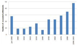
Figure 1: Histogram showing the frequency of roundhouse excavations each decade, based on all settlements included in the database. Interventions at the same site have been included separately where they are the consequence of a newly organised phase of fieldwork.
Data was collected from 189 archaeological sites with excavated roundhouses (representing a maximum of about 750 known excavated houses). Seventy-two of these settlements had radiocarbon dating, although not all dates come from occupation contexts. Sixty-three sites were eventually selected for more detailed data collection. The majority (39%) of the total number of excavated sites were from the north-west region (Gwynedd and Anglesey), but a large proportion of these were from early excavations, reflecting the amount of antiquarian activity in the area (Figure 1, Figure 2). This can be compared to the south-west region (Carmarthenshire, Ceredigion and Pembrokeshire) where 64% of the sites had radiocarbon dating, reflecting the impact of recent development. There is a relative lack of sites (16%) in the north-eastern area (Conwy, Denbighshire, Flintshire and Powys), which may reflect patterns of research and/or a true pattern in the data. The lack of antiquarian sites identified in the south may reflect different regional interests for antiquarians in this period and the availability of information relating to early excavations.
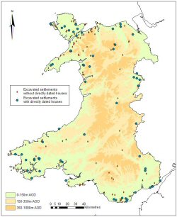
Figure 2: The geographical distribution of settlements in the database with excavated, directly dated roundhouses (Map data: Crown Copyright/database right 2007; an Ordnance Survey/EDINA supplied service).
Approximate dates for all sites were recorded where possible, using a combination of radiocarbon dating and other sources of dating evidence if known. Thirty-two per cent of the sites were undated. Obviously, dating of the older excavations will be less secure and some would benefit from detailed reassessment, which was beyond the scope of this project.
Details were recorded for a total of 287 excavated houses, which comprised all the clearly identifiable circular structures excavated at the 63 sites selected for further collection of house data. Information was collected on the construction, internal features, dating, phasing and finds from these houses. The majority of the houses came from the north-eastern region but this pattern is distorted by the large number of structures excavated on the large hill-top sites at Moel y Gaer, the Breiddin and Dinorben, which together accounted for 75% of the houses from this region.
Although almost all of the houses were from sites with radiocarbon dating, only a quarter of the individual houses were dated by means of radiocarbon alone. While some of the remaining three-quarters of these houses are unlikely to have yielded suitable samples, this low proportion also reflects the tendency to date houses according to the chronology of the settlement and not on an individual basis. This may lead to an under-estimation of the length of occupation of a site, particularly as there is commonly no stratigraphic relationship between external boundaries and internal structures.
The directly radiocarbon-dated houses come from 39 different sites, the greatest number being in north-west Wales. The majority of the dated houses were represented by only one date per house. In some periods the range of radiocarbon dates is so wide as to be largely unhelpful (subtracting earliest and latest radiocarbon dates gives an average life-span for a house of 450 years, which is a reflection of the chronological range of the technique rather than actual use life). It was possible to give a broad date range for about half of the houses using finds and stratigraphic relationships, and combining this with radiocarbon dates gave an approximate chronology for about three-quarters of the houses.
Where it was possible to estimate, over half the houses in the database were 75 to 100% excavated. This represents both extent of excavation and survival of the data: it was possible to estimate internal diameter for 86% of the houses, and doorway location for 61% of the houses. However, survival of internal deposits was much lower: details were given of surviving floor levels in under 20% of houses, while about one third of houses had hearths (this in itself is not an indicator of preservation, as some houses may have been without hearths, but it demonstrates the survival of these features in preference to more short-lived occupation deposits). Generally, there were few stratified finds from the houses.
A particular strength of the house data was the evidence for rebuilding and repair of structures. This demonstrated complex biographies for individual houses and sites. This evidence can be tied more closely to the dating evidence to estimate typical life-spans of buildings, and to relate this activity to patterns of site use and seasonality. Repairs and in situ rebuilding were recorded for each house, but where a house could be said to have been rebuilt on a distinctly different alignment or after a period of disuse it was counted as a separate structure (but with relationships to preceding and subsequent houses marked).
Environmental data were collected where available from sites selected for house data collection (40 sites). This took the form of information about plant macrofossils (including wild species), faunal remains, pollen data (in the form of broad environmental characterisation) and the presence or absence of soil chemical analysis. Pollen data was noted for 20 sites, two of which had off-site pollen only. Data on plant macrofossils were available for 34 sites but faunal remains were less frequently recorded, owing to poor preservation conditions in a large area of Wales.
In total, 428 radiocarbon dates were collected from 72 sites. All dates from each site were recorded, with the exception of environmental dates and in some cases those clearly unrelated to the main phases of occupation of the site in question (for example later medieval dates). There was an average of six radiocarbon dates per site. However, the few sites producing large numbers of dates (such as the Breiddin) have a significant impact on the overall picture; over half of the dates come from just 17% of the sites. An estimated 10% of the total number of dates could be said to be anomalous in some way because of residual or later contamination.
Given the bias of house data towards large hillfort sites in the north-eastern region, the analysis took this into account where it could be seen to affect the result. This was particularly relevant in the case of house dating and doorway orientation, influenced by the large number of houses excavated at Moel y Gaer which may not be typical of the Welsh data in general. A more balanced picture was obtained by taking one house from each broad period for each site.
© Internet Archaeology
URL: http://intarch.ac.uk/journal/issue23/1/1.html
Last updated: Mon Nov 26 2007