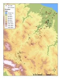
Figure 5: Distribution of villas in the Biferno valley and all other findspots.
A frequent problem when using legacy survey data is the lack of any record of recovery conditions (e.g. which areas were walked and which were not, variable visibility, etc.). As a result, we are not dealing with the presence and absence of sites or material culture; we are dealing with 'presence' alone. This has significant implications. A distribution map of settlement in any particular period is next to useless if we have no understanding of whether gaps or clusters are meaningful. Simple visualisation techniques can help to improve understanding.
Figure 5: Distribution of villas in the Biferno valley and all other findspots.
By plotting particular subsets against the backdrop of all findspots, it is possible to gain some appreciation of whether patterning is meaningful. For example, neither visibility nor the extent of areas walked were recorded by the Biferno valley survey; it is therefore impossible to identify significant patterns such as high visibility areas which produced no surface material. Figure 5 shows the distribution of Roman villas across the Biferno valley visualised against a backdrop of all other findspots. This suggests, for example, that fieldwork was able to locate plenty of findspots in the upper valley, so the absence of villas in this area may be genuine. A simple distribution map of villas, or villas and contemporary settlement, or even villas and sampling transects, would not necessarily have permitted us to come to this conclusion. Presence data are difficult to use and require multiple visualisations to appreciate their significance.
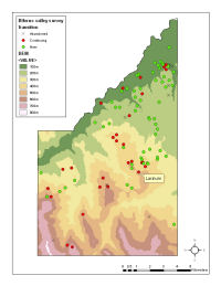
Figure 6: Distribution of Biferno valley survey findspot 'dynamics' in the Larinum case study area. New, continuing and abandoned findspots at the Iron Age / Samnite period transition.
Another approach to the 'presence-only' problem is to map findspots of one particular period in relation to findspots of preceding or subsequent periods. By plotting findspots in terms of continuity, abandonment and foundation, aspects of spatial patterning are better understood because there is some appreciation of 'absence'. For example, within the Larinum case study area, the transition between the Iron Age and Samnite periods is marked by the continuity of settlement in the hilly areas south of Larinum, with a notable spread of new sites on the lowest hills and plain to the north of the town (Figure 6). This visualisation can also be combined with evidence for scatter size and density to suggest a series of small, but continuing sites in the hills, and larger but low density scatters in the lower hills and on the plain. This spatial reorganisation may be associated with the emergence of Larinum as the primary regional centre on the basis of enhanced control and exploitation of the agricultural territory to its north.
Legacy survey data present particular problems of use. Whether considering the relationships of settlement location with soil types or with viewsheds, it is important to have some appreciation of the spatial significance of site distribution. GIS can map anything - no matter how incomplete or biased. It is therefore essential to appreciate how legacy data have been created in order to evaluate whether or not patterns are of any significance. Basic visualisation techniques present one often underappreciated approach.
© Internet Archaeology/Author(s)
URL: http://intarch.ac.uk/journal/issue24/2/3.3.html
Last updated: Mon Jun 30 2008