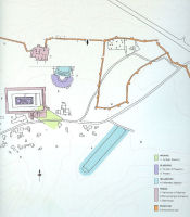
Figure 3: Plan of Isthmia with the major monuments indicated (after Valavanis 2004, 303, fig. 438).
Travelling through the Korinthia in the mid 2nd century CE, one of the first places that the Greek traveller Pausanias described on his journey was the Sanctuary of Poseidon on the Isthmus. 'As you go into the sanctuary', presumably from the stadium, he tells us, 'there are portrait statues of athletes who won at the Isthmian games, and some pine trees in a line, mostly growing straight up' (Pausanias, 2.7). Likely out of a desire to bring to light Pausanias' description, Paul Clement, under the auspices of the University of California, Los Angeles, carried out a series of excavations in an area called the East Field, just to the east of the Temple of Poseidon, an area through which a direct line, and therefore a road, between the Isthmian Hellenistic stadium and Classical temple would probably have run (Figure 3; Clement 1971; 1972; 1973).
Figure 3: Plan of Isthmia with the major monuments indicated (after Valavanis 2004, 303, fig. 438).
Believing the road must have entered the temenos through the Southeast Propylon, only the foundations of which survive, Clement laid out a series of trenches in 1970 through parts of the East Field (Figure 4; Broneer 1973, 77-78). Having found nothing from Pausanias' experience here, the excavators laid out exploratory trenches across nearly the whole of the East Field property over the following two years, completing their investigations in 1972 (Figs 5-6; Clement 1973, 145). The majority of trenches were rectangular, 3m by 10m, and usually laid out in a north-west/southeast or north-east/south-west direction, presumably to follow or to intersect the earlier Archaic stadium retaining walls (which were already known) or to transect other long features. The north-west/south-east orientation of the trenches would be rigidly maintained for subsequent excavation seasons despite the appearance of substantial archaeological remains that were exposed across several trenches, thus making their examination and interpretation often very complicated and difficult.
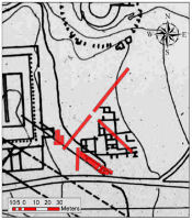
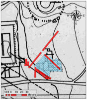
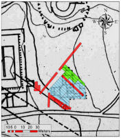
Figure 4: The East Field at Isthmia showing trenches (red) excavated in 1970 by Paul Clement (UCLA).
Figure 5: The East Field at Isthmia showing trenches excavated in 1970 (red) and 1971 (blue) by Paul Clement (UCLA).
Figure 6: The East Field at Isthmia showing all of the trenches excavated by Paul Clement (UCLA). Trenches 1970 (red), 1971 (blue), 1972 (green).
The written records were equally more complex than was necessary and difficult to navigate. Clement recorded his excavations in a series of unpublished trench notebooks in which the site supervisor described and sketched the daily discoveries of finds and features for a single trench within an individual notebook. Any information on the stratigraphic information for 'baskets' (the stratigraphic unit) - or the discovery of artefacts, features, and architecture therein - was therefore recorded in a piecemeal fashion and so was not systematically organised according to material, type, or by any spatial criteria. Once the excavations were completed for each trench, the architecture for that trench was sketched into the trench notebook. These sketch plans give a good indication of the spatial arrangement of the walls for that particular trench, but do not indicate the chronological relationships among the walls, let alone give any sense of architectural shape for the area and its use.
Unable to emulate the good fortune of their Isthmian colleague, Oscar Broneer, who, with his first trench just 20 years earlier, located the Temple of Poseidon, and so the site of Isthmia itself (Broneer 1952; 1971), it is easy for us to empathise with the degree of almost palpable disappointment that the excavators expressed in the publication of their efforts (Clement 1973, 145). Instead of Pausanias' path with its statues of victorious athletes, they had found the inadequately built and poorly preserved walls of small Roman buildings they believed to be just simple houses (Clement 1973, 145).
Clement seemed equally dissatisfied with the overall layout and organisation of the structural remains, for which neither complete nor partial plans were recognisable to him (Clement 1972, 227; 1973, 145). This forlorn sentiment has since served as a veritable epithet for the excavations of the East Field. A notable and particularly frustrating aspect of the site, and one that has hindered still more recent (unpublished) attempts to unravel the architecture left exposed at the site over the past three decades, is that the identifiable walls rarely can be seen to define a complete room, let alone a whole building. While most of the extant walls conform to a more or less north-south/east-west axis, the overall appearance is higgledy-piggledy and generally formless, with not even the insides of premises being discernible from their exteriors. To compound these problems, sections of several walls and features seem to disappear suddenly - some walls were only recognised once they were exposed in later trenches, with other parts of them regrettably removed, probably observed by the excavators, where they had crossed through earlier trenches. A more overt problem with reading the architecture of the East Field is that of chronology: not all of the walls we see today in the field and in plan existed at the same time in antiquity.
Ordinarily, a phased architectural plan might be achieved from a carefully considered stratigraphic excavation. While some care was taken to record the soil strata in the original excavation notebooks, especially with regard to the artefactual record, seldom was this information incorporated with the architecture and, importantly, rarely was the stratigraphic information of and between the walls ever recorded. Instead, Clement made a preliminary examination of the various wall construction techniques with the hope that the establishment of a wall typology that identified walls of similar or identical construction techniques and materials might be expected to have reflected buildings that were erected at the same time. With the architectural shape of the site established, he might then be able to associate the identifiable buildings more meaningfully with any patterns of activity discernible from the recovered, but yet to be contextualised, finds record.
Clement identified three types of wall construction in the East Field: '1) rubble and mortar, usually of good quality, 2) rubble and earth, 3) rubble and mortar with plaster facing' (Clement 1972, 227). He rightly recognised that these categories could be broken down yet further and that many walls exhibit more than one style, something he and his team attributed, very reasonably, to rebuilding. The logical progression of these ideas is that at least some of the wall types have chronological significance and that 'period plans' might be constructed by plotting certain types of walls with others. Some of the more recent attempts to bring clarity to the East Field, particularly those as recently as the mid 1990s, followed this same logic, but aimed at advancing Clement's observations by refining them and identifying close to a dozen wall types to discern the buildings and their phases. These efforts were equally met with frustration as they produced increasingly complex and misleading layers of information which served to confuse rather than to elucidate any real period plan of the site (although unpublished, see the very brief online accounts of these efforts: http://isthmia.osu.edu/93report.html; http://isthmia.osu.edu/96report.html; http://isthmia.osu.edu/97report.html).
The net result is that no discernible buildings have emerged from any of these attempts, let alone any genuine understanding of what activities took place across the area as a whole. Any understanding of a chronological development of this part of the site and how it might be integrated with the better-documented parts of the sanctuary has, therefore, also been difficult to come by. Our challenge has therefore centred on the accessibility of the evidence for this long-since excavated site while simultaneously managing the obstacles presented by the previous methodologies in creating these data.
© Internet Archaeology/Author(s)
URL: http://intarch.ac.uk/journal/issue24/3/2.html
Last updated: Mon Jun 30 2008